Watersmeet Lake (Eagle Chain), Eagle River,Sugar Camp Creek,Tamarack Pioneer River Watershed (UW42)
Watersmeet Lake (Eagle Chain) (1599400)
100 Acres
Natural Community
Natural communities (stream and lake natural communities) represent model results that use predicted flow and temperature based on landscape features and related assumptions. Ranges of flow and temperature associated with specific aquatic life communities (fish, macroinvertebrates) help biologists identify appropriate resource management goals. Wisconsin Natural Communities.
Impounded Flowing Water
Year Last Monitored
This is the most recent date of monitoring data stored in SWIMS. Additional surveys for fish and habitat may be available subsequent to this date.
2024
Good
 
Vilas
Trout Water 
Trout Waters are represented by Class I, Class II or Class III waters. These classes have specific ecological characteristics and management actions associated with them. For more information regarding Trout Classifications, see the Fisheries Trout Class Webpages.
No
Outstanding or Exceptional 
Wisconsin has designated many of the state's highest quality waters as Outstanding Resource Waters (ORWs) or Exceptional Resource Waters (ERWs). Waters designated as ORW or ERW are surface waters which provide outstanding recreational opportunities, support valuable fisheries and wildlife habitat, have good water quality, and are not significantly impacted by human activities. ORW and ERW status identifies waters that the State of Wisconsin has determined warrant additional protection from the effects of pollution. These designations are intended to meet federal Clean Water Act obligations requiring Wisconsin to adopt an 'antidegradation' policy that is designed to prevent any lowering of water quality - especially in those waters having significant ecological or cultural value.
No
Impaired Water 
A water is polluted or 'impaired' if it does not support full use by humans, wildlife, fish and other aquatic life and it is shown that one or more of the pollutant criteria are not met.
No

Fish and Aquatic Life

Current Use
The use the water currently supports. This is not a designation or classification; it is based on the current condition of the water. Information in this column is not designed for, and should not be used for, regulatory purposes.
Impounded Flowing Water
This classification includes waterbodies created by dams (mill ponds, reservoirs, flowages, and other impoundments) with a residence time of 14 days or more (under summer (June – Sept) mean low flow conditions with a 1 in 10 year recurrence interval (US EPA 2000)). Many natural lakes also have dams or water level control structures. However, to be included in the Impounded Flowing Waters category, the dam or water level control structure, must account for more than half of a waterbody’s maximum depth. Impoundments with a residence time of less than 14 days should be covered under the rivers and stream assessment methodology process.
Attainable Use
The use that the investigator believes the water could achieve through managing "controllable" sources. Beaver dams, hydroelectric dams, low gradient streams, and naturally occurring low flows are generally not considered controllable. The attainable use may be the same as the current use or it may be higher.
Default FAL
Fish and Aquatic Life - Default Waters do not have a specific use designation subcategory but are considered fishable, swimmable waters.
Designated Use
This is the water classification legally recognized by NR102 and NR104, Wis. Adm. Code. The classification determines water quality criteria and effluent limits. Waters obtain designated uses through classification procedures.
Default FAL
Fish and Aquatic Life - Default Waters do not have a specific use designation subcategory but are considered fishable, swimmable waters.

Overview

, in the Eagle River, Sugar Camp Creek and Tamarack Pioneer River Watersheds, is a 106.96 acre lake that falls in Vilas County. This lake is managed for fishing and swimming and is currently not considered impaired.

Date  2011

Author   Aquatic Biologist

Historical Description

Source: 1963, Surface Water Resources of Vilas County Watersmeet Lake, T-40-N, R-10-E, Sections 30 and 31,

Watersmeet Lake is an impoundment of moderate fertility, having slightly alkaline, light brown water of moderate transparency. The bottom material is composed principally of sand with small amounts of gravel and muck present. Both the inlet and the outlet streams are considered navigable. Much of the depth is traceable to the 13-foot high power dam across the Wisconsin River. The head of water held by the dam links the entire Eagle Chain. Muskellunge, northern pike, walleye, largemouth bass and pan fish constitute the principal fish species present. Public access is possible by means of a town road with nearby parking facilities, by a state highway without nearby parking facilities, and by navigating the inlet or outlet streams. Public use facilities consist of eight resorts and three boat rental establishments. There are 57 cottages located on the shore line, as well as five farms. Puddle ducks, diving ducks and coots are known to use this lake on their spring and fall migrations.

Area = 100 Surface Acres, Maximum Depth = 12 feet

Date  1963

Author   Surface Water Inventory Of Wisconsin

Watersmeet Lake (Eagle Chain), Eagle River,Sugar Camp Creek,Tamarack Pioneer River Watershed (UW42) Fish and Aquatic LifeWatersmeet Lake (Eagle Chain), Eagle River,Sugar Camp Creek,Tamarack Pioneer River Watershed (UW42) RecreationWatersmeet Lake (Eagle Chain), Eagle River,Sugar Camp Creek,Tamarack Pioneer River Watershed (UW42) Fish Consumption

Condition

Wisconsin has over 84,000 miles of streams, 15,000 lakes and milllions of acres of wetlands. Assessing the condition of this vast amount of water is challenging. The state's water monitoring program uses a media-based, cross-program approach to analyze water condition. An updated monitoring strategy (2015-2020) is now available. Compliance with Clean Water Act fishable, swimmable standards are located in the Executive Summary of Water Condition in 2018. See also the 'monitoring and projects' tab.

Reports

Management Goals

Wisconsin's Water Quality Standards provide qualitative and quantitative goals for waters that are protective of Fishable, Swimmable conditions [Learn more]. Waters that do not meet water quality standards are considered impaired and restoration actions are planned and carried out until the water is once again fishable and swimmable

Management goals can include creation or implementation of a Total Maximum Daily Load analysis, a Nine Key Element Plan, or other restoration work, education and outreach and more. If specific recommendations exist for this water, they will be displayed below online.

Monitoring

Monitoring the condition of a river, stream, or lake includes gathering physical, chemical, biological, and habitat data. Comprehensive studies often gather all these parameters in great detail, while lighter assessment events will involve sampling physical, chemical and biological data such as macroinvertebrates. Aquatic macroinvertebrates and fish communities integrate watershed or catchment condition, providing great insight into overall ecosystem health. Chemical and habitat parameters tell researchers more about human induced problems including contaminated runoff, point source dischargers, or habitat issues that foster or limit the potential of aquatic communities to thrive in a given area. Wisconsin's Water Monitoring Strategy was recenty updated.

Grants and Management Projects

Monitoring Projects

Watershed Characteristics

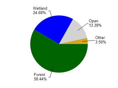
Watersmeet Lake is located in the Sugar Camp Creek watershed which is 187.99 mi². Land use in the watershed is primarily forest (58.50%), wetland (24.70%) and a mix of open (13.40%) and other uses (3.50%). This watershed has 123.61 stream miles, 11,669.73 lake acres and 30,139.17 wetland acres.

Nonpoint Source Characteristics

This watershed is ranked Not Ranked for runoff impacts on streams, Medium for runoff impacts on lakes and Low for runoff impacts on groundwater and therefore has an overall rank of Low. This value can be used in ranking the watershed or individual waterbodies for grant funding under state and county programs.However, all waters are affected by diffuse pollutant sources regardless of initial water quality. Applications for specific runoff projects under state or county grant programs may be pursued. For more information, go to surface water program grants.

Natural Community

Watersmeet Lake (Eagle Chain) is considered a Impounded Flowing Water under the state's Natural Community Determinations.

Natural communities (stream and lake natural communities) represent model results and DNR staff valiation processes that confirm or update predicted conditions based on flow and temperature modeling from historic and current landscape features and related variables. Predicated flow and temperatures for waters are associated predicated fish assemblages (communities). Biologists evaluate the model results against current survey data to determine if the modeled results are corect and whether biological indicators show water quaity degradation. This analysis is a core component of the state's resource management framework. Wisconsin's Riverine Natural Communities.

This classification includes waterbodies created by dams (mill ponds, reservoirs, flowages, and other impoundments) with a residence time of 14 days or more (under summer (June – Sept) mean low flow conditions with a 1 in 10 year recurrence interval (US EPA 2000)). Many natural lakes also have dams or water level control structures. However, to be included in the Impounded Flowing Waters category, the dam or water level control structure, must account for more than half of a waterbody’s maximum depth. Impoundments with a residence time of less than 14 days should be covered under the rivers and stream assessment methodology process.

More Interactive Maps