General Condition
Deerskin River (miles 1.06-4.5) was assessed during the 2018 listing cycle; new total phosphorus and temperature sample data were clearly below the 2018 WisCALM listing thresholds for the Fish and Aquatic Life use. This water was meeting this designated use and was not considered impaired.
Date 2017
Author Ashley Beranek
General Condition
Deerskin River (miles 8.93-13.37) was assessed during the 2018 listing cycle; new total phosphorus and temperature sample data were clearly below the 2018 WisCALM listing thresholds for the Fish and Aquatic Life use. This water was meeting this designated use and was not considered impaired.
Date 2017
Author Ashley Beranek
Condition
Wisconsin has over 84,000 miles of streams, 15,000 lakes and milllions of acres of wetlands. Assessing the condition of this vast amount of water is challenging. The state's water monitoring program uses a media-based, cross-program approach to analyze water condition. An updated monitoring strategy (2015-2020) is now available. Compliance with Clean Water Act fishable, swimmable standards are located in the Executive Summary of Water Condition in 2018. See also the 'monitoring and projects' tab.
Reports
Recommendations
Citizen-Based Stream Monitoring
Collect chemical, physical, and/or biological water quality data to assess the current overall stream health. The data can inform management decisions and may be used to identify impaired waters for biennial lists.
Citizen-Based Stream Monitoring
Collect chemical, physical, and/or biological water quality data to assess the current overall stream health. The data can inform management decisions and may be used to identify impaired waters for biennial lists.
Citizen-Based Stream Monitoring
Monitoring of water quality by stream volunteers on the Deerskin River.
Lake Management Plan Implementation
The Town of Washington is sponsoring a project on Anvil Lake, Vilas County. The project will focus on studying water quality and developing an Anvil Lake Management Plan (LMP). Project activities include: 1) Develop water and P budget; 2) Water quality evaluation and groundwater assessment; 3) WiLMS simulation modeling; 4) Stakeholder participation; 5) Collect sediment cores for historical and future lake water quality assessment; 6) Implementation of County sewage ordinance and association shoreline restoration project; 7) Develop annual reports, a scientific investigations report and LMP.
Monitor Water Quality or Sediment
This is a trout water (Class II) and so is required to meet cold-water standards. Biologists comments from last assessment cycle indicate that this is a naturally occuring state - listing as 5C.
I disagree for listing based on many factors. 1) where in the channel is the thermistor deployed? It is very easy to deploy it in the wrong part of the channel which can easily produce elevated temperatures. 2)what is the thermistors accuracy? has the data set been adjusted to reflect the accuracy? 3)Is the thermistor checked against a certified thermometer on a yearly basis to check it's accuracy? 4)Is the thermistor deployed with a sunshield? Research studies done in cold mountain streams show thermistors unshielded can easily record temperatures over 1 degree C warmer than shielded thermistors placed adjacent to them. This alone should be reason enough not to list. 5)My comments from the last review have not changed. 6)Not being my study, there are too many factors I am unaware of and have no control over that I cannot agree with listing. We as the biologists should not be required to review and possibly list streams using studies and data we have no control over.
Management Goals
Wisconsin's Water Quality Standards provide qualitative and quantitative goals for waters that are protective of Fishable, Swimmable conditions [Learn more]. Waters that do not meet water quality standards are considered impaired and restoration actions are planned and carried out until the water is once again fishable and swimmable
Management goals can include creation or implementation of a Total Maximum Daily Load analysis, a Nine Key Element Plan, or other restoration work, education and outreach and more. If specific recommendations exist for this water, they will be displayed below online.
Monitoring
Monitoring the condition of a river, stream, or lake includes gathering physical, chemical, biological, and habitat data. Comprehensive studies often gather all these parameters in great detail, while lighter assessment events will involve sampling physical, chemical and biological data such as macroinvertebrates. Aquatic macroinvertebrates and fish communities integrate watershed or catchment condition, providing great insight into overall ecosystem health. Chemical and habitat parameters tell researchers more about human induced problems including contaminated runoff, point source dischargers, or habitat issues that foster or limit the potential of aquatic communities to thrive in a given area. Wisconsin's Water Monitoring Strategy was recenty updated.
Grants and Management Projects
Monitoring Projects
| WBIC | Official Waterbody Name | Station ID | Station Name | Earliest Fieldwork Date | Latest Fieldwork Date | View Station | View Data |
|---|
| 1600400 | Deerskin River | 10029414 | Deerskin River at FR2178 | 5/21/2005 | 10/6/2025 | Map | Data |
| 1600400 | Deerskin River | 10029415 | DEERSKIN RIVER - OLD HATCHERY ACCESS OFF OF BLACKJACK RD. | 6/3/2005 | 7/9/2026 | Map | Data |
| 1600400 | Deerskin River | 10016754 | Deerskin River - Logging Road Off Of Fr-2199 | 9/26/2002 | 9/26/2002 | Map | Data |
| 1600400 | Deerskin River | 10016751 | Deerskin R. - Above Deerskin Dam - Just Abovesteep Bank W/ Access Rd | 9/23/1999 | 9/23/1999 | Map | Data |
| 1600400 | Deerskin River | 10029413 | DEERSKIN RIVER - BOARD BRIDGE RD | 1/1/2015 | 1/1/2015 | Map | Data |
|
Watershed Characteristics
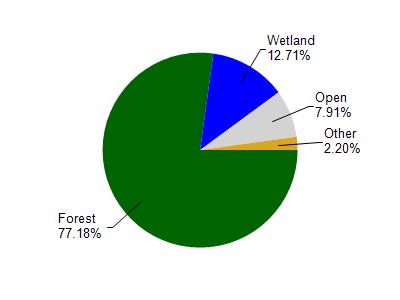
Deerskin River is located in the Deerskin River watershed which is 56.88 mi². Land use in the watershed is primarily forest (77.10%), wetland (12.70%) and a mix of open (7.90%) and other uses (2.20%). This watershed has 63.93 stream miles, 3,047.79 lake acres and 4,928.98 wetland acres.
Nonpoint Source Characteristics
This watershed is ranked Low for runoff impacts on streams, Medium for runoff impacts on lakes and Low for runoff impacts on groundwater and therefore has an overall rank of Low. This value can be used in ranking the watershed or individual waterbodies for grant funding under state and county programs.However, all waters are affected by diffuse pollutant sources regardless of initial water quality. Applications for specific runoff projects under state or county grant programs may be pursued. For more information, go to surface water program grants.