Dunn
No
No
Yes
Fish and Aquatic Life
Overview
Tainter Lake is a hypereutrophlc impoundment on the Red Cedar River at Cedar Falls. A water quality assessment conducted on Tainter Lake from February, 1989, through October, 1990 had as its objective determining the impacts of the annual phosphorus load on water quality in Tainter Lake and what phosphorus load reductions would significantly improve water quality (Mechelke).
The study found that growing season (May-September) phosphorus inputs had the most significant effect on water quality in Tainter Lake. The study concluded that 84 percent of these phosphorus loads are controllable, of which 9 percent can be attributed to point sources and 75 percent to polluted runoff. The study concluded that Tainter Lake water quality will not respond to small decreases in phosphorus loading. To achieve a significant reduction in chlorophyll a, representing algal populations, it would require a 65-70 percent reduction in the amount of growing season polluted runoff and phosphorus limits on point source dischargers. A recent calibration of the
model predicted that a 50-60 percent phosphorus load reduction would effect the same change (Schreiber 1995).
The water quality study concluded that it will take an intensive effort to reduce phosphorus loading throughout the Red Cedar drainage basin above Tainter Lake if water quality is to significantly improve (Schreiber). Efforts to improve other lake attributes should not be ignored. Shoreline
aesthetics and fishery habitat are two areas that could be worked on by the lake community to improve the recreational use of Tainter Lake.
Recommendations from the study include developing another study to determine the feasibility of and means of reducing the phosphorus load to Tainter Lake; establishment of long-term phosphorus monitoring stations to assess annual variability in phosphorus loads. Mercury concentrations in walleye exceed the advisory criteria in Tainter Lake, although Lake
Menomin walleye do not. The mercury concentration trend in fish is inconsistent with that seen statewide. A small sample size may be influencing the data or there may be something unique occurring in ths system. Collection of additional walleye and smallmouth bass from Tainter Lake
may help clarify the data. PCB analysis needs to be conducted on whte sucker and larger walleye and bass (Amrhein)
Date 1996
Author Aquatic Biologist
Historical Description
A hardwater, drainage impoundment on the Red Cedar River. Hay River, Lambs Creek and another feeder stream in Section 30 also flow into Tainter Lake. All the named streams are navigable at their outlets. A 52-foot head public utility dam (Northern States Power Company) is located on the outlet (1, 200 cfs) of the lake at Cedar Falls. Managed for walleyes, bass and pan fish, its most common fish species are walleyes, perch, brown and yellow bullheads, carp and white suckers. Other species present are northern pike, largemouth bass, smallmouth bass, bluegills, black crappies, white crappies, rock bass, pumpkinseed, green sunfish, black bullheads, northern redhorse and bowfins. Carp, algal blooms and occasional fluctuating water levels are a problem to management of this impoundment. A quarter of a mile of frontage is in public ownership. This includes Champney Memorial Park-, Lamb's Creek Park (county), northwest public access (Northwest Rod and Gun Club),
another public access at Pine Point and four undeveloped platted accesses. Private development includes 16 resorts, three boat liveries, a trailer park camping area and 31 cottages and dwellings. Ten acres of marsh wetlands provide habitat for muskrats and nesting mallards, blue-winged teal and wood ducks. A number of diving ducks, coots and occasionally Canada geese are also found here during migration seasons. Source: 1962, Surface Water Resources of Dunn County Tainter Lake T29N, R12W, Sec. 7 Surface Acres = 1, 752.0, S. D. F. = 4.38, Maximum Depth = 37 feet
Date 1962
Author Surface Water Inventory Of Wisconsin
Impaired Waters
Tainter Lake (WBIC 2068000) was placed on the impaired waters list for total phosphorus in 1998. The TMDL for phosphorus was approved by the U.S. EPA in 2012. The 2018 assessments showed continued impairment by phosphorus; new total phosphorus and chlorophyll sample data exceeded 2018 WisCALM listing thresholds for the Recreation use and Fish and Aquatic Life use. Based on the most updated information, no change in the existing impaired waters listing was needed.
Date 2017
Author Ashley Beranek
Impaired Waters
Tainter Lake (2068000) was placed on the impaired waters list for total phosphorus in 1998. The TMDL for phosphorus was approved by the U.S. EPA in 2012. The 2016 assessments showed continued impairment by phosphorus; total phosphorus sample data overwhelmingly exceeded 2016 WisCALM listing thresholds for the Recreation use and Fish and Aquatic Life use, and chlorophyll data overwhelmingly exceeded FAL thresholds and exceeded REC thresholds. Based on the most updated information, no change in existing impaired waters listing is needed.
Date 2015
Author Aaron Larson
Condition
Wisconsin has over 84,000 miles of streams, 15,000 lakes and milllions of acres of wetlands. Assessing the condition of this vast amount of water is challenging. The state's water monitoring program uses a media-based, cross-program approach to analyze water condition. An updated monitoring strategy (2015-2020) is now available. Compliance with Clean Water Act fishable, swimmable standards are located in the Executive Summary of Water Condition in 2018. See also the 'monitoring and projects' tab.
Reports
Recommendations
Shoreland Ordinance
Dunn County proposes to amend or create a shoreland zoning ordinance that complies with the requirements of NR 115, Wisconsin Administrative Code (as revised effective February 1, 2010) and retain existing regulations that exceed the water resource protections of NR 115 or are specific or unique to local needs.
Monitor Fish Tissue
TMDL (USEPA) Approved
EPA finds that the TP TMDLs for Tainter Lake and Lake Menomin satisfy all of the elements of an approvable TMDL. This approval is for 2 waterbody segments impaired by total phosphorus for a total of 2 TMDLs. These TMDLs address the eutrophication impairments on these lakes.
TMDL Implementation
Phosphorus TMDL Implementation for Lakes Menomin and Tainter.
Implementation Plan is needed.
TMDL Implementation
Phosphorus TMDLs for Lakes Menomin and Tainter were completed in May 2012 and approved by the EPA on September 14, 2012. These "lakes" are impoundments of the Red Cedar River. The Red Cedar River drains portions of seven counties; land use is primarily agriculture which contributes to excess phosphorus leading to recreational impairments (unsightly blue-green algal blooms that limit wading, swimming and boating) in Lake Menomin and Tainter Lake. Please visit the UW-Extension Red Cedar River Watershed website for more information and details on outreach activites associated with the TMDL and the Lower Chippewa Basin.
Management Goals
Wisconsin's Water Quality Standards provide qualitative and quantitative goals for waters that are protective of Fishable, Swimmable conditions [Learn more]. Waters that do not meet water quality standards are considered impaired and restoration actions are planned and carried out until the water is once again fishable and swimmable
Management goals can include creation or implementation of a Total Maximum Daily Load analysis, a Nine Key Element Plan, or other restoration work, education and outreach and more. If specific recommendations exist for this water, they will be displayed below online.
Monitoring
Monitoring the condition of a river, stream, or lake includes gathering physical, chemical, biological, and habitat data. Comprehensive studies often gather all these parameters in great detail, while lighter assessment events will involve sampling physical, chemical and biological data such as macroinvertebrates. Aquatic macroinvertebrates and fish communities integrate watershed or catchment condition, providing great insight into overall ecosystem health. Chemical and habitat parameters tell researchers more about human induced problems including contaminated runoff, point source dischargers, or habitat issues that foster or limit the potential of aquatic communities to thrive in a given area. Wisconsin's Water Monitoring Strategy was recenty updated.
Grants and Management Projects
Monitoring Projects
| WBIC | Official Waterbody Name | Station ID | Station Name | Earliest Fieldwork Date | Latest Fieldwork Date | View Station | View Data |
|---|
| 2068000 | Tainter Lake | 10034345 | Tainter Lake - HAB sample site | | | Map | Data |
| 2068000 | Tainter Lake | 173216 | Tainter Lake - South Basin - Site 3 /South Bay | 9/26/1989 | 7/11/2026 | Map | Data |
| 2068000 | Tainter Lake | 10041749 | Tainter Lake Western Basin | | | Map | Data |
| 2068000 | Tainter Lake | 10018093 | Tainter Lake -- Access at Kliest Landing | 8/5/2007 | 6/8/2025 | Map | Data |
| 2068000 | Tainter Lake | 10030546 | Tainter Lake off end of 852nd street | 9/9/2009 | 9/9/2009 | Map | Data |
| 2068000 | Tainter Lake | 10018488 | Tainter Lake -- Access | 8/4/2007 | 6/16/2015 | Map | Data |
| 2068000 | Tainter Lake | 10030267 | Tainter Lake | 6/23/2009 | 7/28/2020 | Map | Data |
| 2068200 | Lambs Creek | 10011991 | Lambs Creek 39m U.S. Of Cth D | 6/8/2004 | 9/7/2019 | Map | Data |
| 2068000 | Tainter Lake | 173124 | Tainter Lake - Deep Hole | 9/13/1973 | 10/7/1974 | Map | Data |
| 2068000 | Tainter Lake | 173215 | Tainter Lake - Middle Basin - Site 2 | 9/26/1989 | 7/11/2026 | Map | Data |
| 2068000 | Tainter Lake | 10002311 | Tainter Lake | 5/15/1995 | 12/10/2024 | Map | Data |
| 2068000 | Tainter Lake | 173214 | Tainter Lake - North Basin - Site 1 /Middle Of Red Cedar Lobe | 9/26/1989 | 7/11/2026 | Map | Data |
| 2068000 | Tainter Lake | 10012367 | Tainter Lake -- Northwest Boat Landing | 8/18/2004 | 7/25/2023 | Map | Data |
| 2068000 | Tainter Lake | 10018155 | Tainter Lake -- Chapany Park Access | 7/24/2005 | 8/8/2023 | Map | Data |
| 2068000 | Tainter Lake | 10048859 | Tainter Lake - WI Lakes Partnership Site | 8/3/2017 | 8/3/2017 | Map | Data |
| 2068000 | Tainter Lake | 10031498 | Tainter Lake - below CTH D bridge | 7/9/2010 | 9/14/2011 | Map | Data |
| 2068000 | Tainter Lake | 10057745 | Tainter Lake - Zebra Mussel Sampler Location | 6/15/2023 | 5/30/2026 | Map | Data |
|
Watershed Characteristics
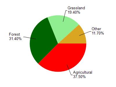
Tainter Lake is located in the Wilson Creek watershed which is 244.75 mi². Land use in the watershed is primarily agricultural (37.50%), forest (31.40%) and a mix of grassland (19.40%) and other uses (11.70%). This watershed has 425.11 stream miles, 1,332.74 lake acres and 5,388.38 wetland acres.
Nonpoint Source Characteristics
This watershed is ranked High for runoff impacts on streams, High for runoff impacts on lakes and High for runoff impacts on groundwater and therefore has an overall rank of High. This value can be used in ranking the watershed or individual waterbodies for grant funding under state and county programs.This water is ranked High Lake for individual Impoundments based on runoff problems and the likelihood of success from project implementation.