Vilas
No
No
No
Fish and Aquatic Life
Overview
Lac Vieux Desert, in the Tamarack Pioneer River Watershed, is a 4,017.28 acre lake that falls in Vilas County. This lake is an outstanding/exceptional resource water under NR102 under the Fisheries Program. This lake is managed for fishing and swimming and is currently not considered impaired.
Date 2011
Author Aquatic Biologist
Historical Description
Source: 1963, Surface Water Resources of Vilas County
Lac Vieux Desert Lake, T-42-N, R-11-E, Sections 9, 10, and 11, Area
= 2,853 Surface Acres, Maximum Depth = 38 feet
Lac Vieux Desert is the origin of the Wisconsin River and is a
moderately fertile drainage lake. It has clear water of low to
moderate transparency, depending somewhat upon the algal response
to the lake's fertility. A variety of bottom materials are present
in the lake--35 per cent sand, 40 per cent gravel, 10 per cent rock
and 35 per cent muck approximate the percentages of the shore line
bottom type composition. Both the inlet and the outlet streams are
freely navigable. At the outlet there is a water control structure
intended to store water for low floor augmentation. This creates a
fluctuating water level, the allowable fluctuation being 2 feet-10
inches. The lake contains muskellunge and walleye, and muskellunge
are considered common while walleyes are considered to be abundant.
Other fish species present are northern pike, large and smallmouth
bass and pan fish. Three forms of public access are available on
the Wisconsin side of this Michigan-Wisconsin boundary water.
There is a county boat landing area which provides public access,
as well as access by a town road with parking and navigable water
access. Public use facilities consist of 14 resorts (Michigan boat
rental facilities are available at some resorts. There are 69
cottages located on or about the shore line. Muskrats are
considered a significant fur bearer and the lake has had a history
of beaver colonies present about the shore line. The lake is one
of the outstanding waterfowl lakes of Vilas County. The lake
produces numerous broods of mallard, bluewing teal and wood ducks,
as well as broods of hooded mergansers. In the spring and fall,
the lake is used quite heavily by puddle ducks and diving ducks as
well as by coots and Canada geese.
Date 1963
Author Surface Water Inventory Of Wisconsin
Management Goals
Wisconsin's Water Quality Standards provide qualitative and quantitative goals for waters that are protective of Fishable, Swimmable conditions [Learn more]. Waters that do not meet water quality standards are considered impaired and restoration actions are planned and carried out until the water is once again fishable and swimmable
Management goals can include creation or implementation of a Total Maximum Daily Load analysis, a Nine Key Element Plan, or other restoration work, education and outreach and more. If specific recommendations exist for this water, they will be displayed below online.
Monitoring
Monitoring the condition of a river, stream, or lake includes gathering physical, chemical, biological, and habitat data. Comprehensive studies often gather all these parameters in great detail, while lighter assessment events will involve sampling physical, chemical and biological data such as macroinvertebrates. Aquatic macroinvertebrates and fish communities integrate watershed or catchment condition, providing great insight into overall ecosystem health. Chemical and habitat parameters tell researchers more about human induced problems including contaminated runoff, point source dischargers, or habitat issues that foster or limit the potential of aquatic communities to thrive in a given area. Wisconsin's Water Monitoring Strategy was recenty updated.
Grants and Management Projects
| Project Name (Click for Details) | Year Started |
|---|
| LAC VIEUX DESERT LAKE ASSOCIATION, INC: Lac Vieux Desert AIS Prevention & Control Project | 2020 |
| LAC VIEUX DESERT LAKE ASSOCIATION, INC: Aquatic Plant Management Plan - Lac Vieux Desert | 2025 |
| LAC VIEUX DESERT LAKE ASSOCIATION, INC: Lac Vieux Desert 2015 Clean Boats Clean Waters Project | 2015 |
| LAC VIEUX DESERT LAKE ASSOCIATION, INC: Lac Vieux Desert Lake Association, Inc 2018 CBCW | 2018 |
| LAC VIEUX DESERT LAKE ASSOCIATION, INC: Lac Vieux Desert Lake Management Planning Project, Phase 1 | 2009 |
| LAC VIEUX DESERT LAKE ASSOCIATION, INC: Lac Vieux Desert Lake Management Planning Project, Phase III | 2009 |
| LAC VIEUX DESERT LAKE ASSOCIATION, INC: Lac Vieux Desert Lake Clean Boats Clean Waters Project 2014 | 2014 |
| LAC VIEUX DESERT LAKE ASSOCIATION, INC: Lac Vieux Desert Aquatic Invasive Species Prevention & Control Project | 2014 |
| LAC VIEUX DESERT LAKE ASSOCIATION, INC: Lac Vieux Desert Lake Management Planning Project, Phase 2 | 2009 |
| LAC VIEUX DESERT LAKE ASSOCIATION, INC: Lac Vieux Desert Clean Boats Clean Waters 2013 | 2013 |
| TOWN OF PHELPS: Town of Phelps Dissolved Oxygen Meter | 2009 |
| LAC VIEUX DESERT LAKE ASSOCIATION, INC: Lac Vieux Desrt Lake Association 2016 Clean Boats Clean Waters | 2016 |
| TOWN OF PHELPS: Town of Phelps Management Planning, Phase 2 | 1998 |
| LAC VIEUX DESERT LAKE ASSOCIATION, INC: Lac Vieux Desert Lake Association, Inc 2017 CBCW | 2017 |
| LAC VIEUX DESERT LAKE ASSOCIATION, INC: Lac Vieux Desert Lake Association, Inc 2022 CBCW | 2022 |
| TOWN OF PHELPS: Town of Phelps Lake Inventory and Land Use Plan | 1998 |
| LAC VIEUX DESERT LAKE ASSOCIATION, INC: Lac Vieux Desert Lake ASI Plan Project | 2018 |
| LAC VIEUX DESERT LAKE ASSOCIATION, INC: Lac Vieux Desert Lake Association, Inc 2019 CBCW | 2019 |
| LAC VIEUX DESERT LAKE ASSOCIATION, INC: Lac Vieux Desert AIS Prevention & Control Project (2023-2025) | 2023 |
| Fish Propagation Actions | 2001 |
| LAC VIEUX DESERT LAKE ASSOCIATION, INC: Lac Vieux Desert Eurasian Watermilfoil Rapid Response Project | 2008 |
| LAC VIEUX DESERT LAKE ASSOCIATION, INC: Lac Vieux Desert Lake Association, Inc 2020 CBCW | 2020 |
| LAC VIEUX DESERT LAKE ASSOCIATION, INC: Lac Vieux Desert Lake Association, Inc 2021 CBCW | 2021 |
| LAC VIEUX DESERT LAKE ASSOCIATION, INC: Lac Vieux Desert Lake Association, Inc 2023 CBCW | 2023 |
|
Monitoring Projects
| WBIC | Official Waterbody Name | Station ID | Station Name | Earliest Fieldwork Date | Latest Fieldwork Date | View Station | View Data |
|---|
| 1631900 | Lac Vieux Desert | 10005973 | Lac Vieux Desert | 7/27/1999 | 9/30/2017 | Map | Data |
| 1631900 | Lac Vieux Desert | 10019807 | Lac Vieux Desert -- National Forest Campground Boat Access | 8/6/2009 | 10/15/2023 | Map | Data |
| 1631900 | Lac Vieux Desert | 10049590 | Lac Vieux Desert - National Forest campground beach | 6/1/2017 | 8/25/2019 | Map | Data |
|
Watershed Characteristics
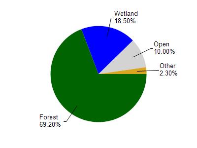
Lac Vieux Desert is located in the Tamarack Pioneer River watershed which is 209.26 mi². Land use in the watershed is primarily forest (69.20%), wetland (18.50%) and a mix of open (10%) and other uses (2.30%). This watershed has 183.22 stream miles, 14,006.68 lake acres and 23,826.05 wetland acres.
Nonpoint Source Characteristics
This watershed is ranked Low for runoff impacts on streams, Medium for runoff impacts on lakes and Low for runoff impacts on groundwater and therefore has an overall rank of Low. This value can be used in ranking the watershed or individual waterbodies for grant funding under state and county programs.However, all waters are affected by diffuse pollutant sources regardless of initial water quality. Applications for specific runoff projects under state or county grant programs may be pursued. For more information, go to surface water program grants.