Dane
No
No
No
Fish and Aquatic Life
Overview
Rock River Water Quality Management Plan, Lower Rock River Appendix. WT-668-2002. South Central Region, WDNR.
Koshkonong Creek (Lower) This reach of Koshkonong Creek still flows in its natural channel for most of its distance. Lower Koshkonong Creek is a low-gradient, meandering stream, which has formed a small delta at its mouth on Lake Koshkonong. The only impoundment on the creek, the Rockdale dam, was breached in September 2000 and removed in June 2001. Stream bank restoration and revegetation to reduce sedimentation downstream is in progress. The removal of the Rockdale dam will improve fish migration and habitat quality of the stream. A partnership with the University of Wisconsin-Madison will provide a detailed analysis on sedimentation movement after dam removal. The stream is classified as a warm water sport fishery, but its uses and potential are impaired by agricultural runoff. Highly intensive agricultural operations, including one muck farm, in the drainage area affect water quality. The Upper Koshkonong Watershed contributes a significant portion of nutrient and sediment loads.
Bullhead and rough fish dominate the fishery although northern pike provide a fair fishery in the lower reaches. Wetlands near the creek mouth provide spawning areas for northern pike.
Date 2002
Author Aquatic Biologist
Overview
Rock River Water Quality Management Plan, Lower Rock River Appendix. WT-668-2002. South Central Region, WDNR.
Koshkonong Creek (Upper) Rising on the east edge of the city of Sun Prairie, much of the creek's headwaters are ditched and straightened. This river exhibits natural limiting conditions as well, such as a flat gradient, low base flow, warm temperatures, and high inputs of sediment and nutrients from the fertile watershed. Agricultural land use, urban development and hydrologic modifications result in sluggish flows, river stretches clogged with debris, and overall poor water quality. Most of its tributary streams have also been ditched and are also clogged with debris. The creek's substrate consists of thick silt, probably washed from nearby farm fields, and sludge from the Sun Prairie wastewater treatment plant lying over gravel.
Above County Trunk Highway T the creek supports a few tolerant forage species. From its headwaters to Hwy. T, the river is classified as supporting limited aquatic life, or marginal surface waters. Although the stream is marginal, Hilsenhoff Biotic Index data from 1989 indicated water quality in the stream improved from “very poor” to “poor.” Base flow monitoring in 1990 showed high levels of phosphorus, chloride, fecal coliform bacteria, ammonia-nitrogen, and nitrate-nitrogen at the Baily Road monitoring site (DCRPC 1995).
Below Highway T, Koshkonong Creek is classified as a warm water sport fishery, though it is severely affected by polluted runoff and past point source discharges. Research into water quality improvements from the upgrade of the Sun Prairie wastewater treatment plant examined aquatic insects via the Hilsenhoff Biotic Index and the stream's chemical water quality. These studies showed improvement in water quality based on chemical parameters only. The biotic index indicated less improvement than anticipated, possibly due to the persistent effects of sludge deposits on the stream bottom coupled with ongoing polluted runoff.
Date 2002
Author Aquatic Biologist
Overview
Lake Koshkonong A large shallow impoundment of the Rock River, Lake Koshkonong exhibits the same water quality problems as other impoundments in southern Wisconsin but on a much larger scale. The lake was originally a shallow and deep-water marsh; a dam constructed in 1850 created a shallow lake. The dam was rebuilt in 1917, raising the lake level an additional two feet. The lake is a major stop-over for migratory waterfowl and was renowned for waterfowl hunting. The drainage area above the lake encompasses 2,640 square miles.
Tremendous sediment and nutrient loads from the Rock River, Koshkonong Creek and other tributaries enter the lake annually. These loads are primarily from agricultural and some urban sources. In addition, shoreline erosion is severe on the lake. Failing septic systems were a problem in the past but the creation of a sanitary district around a portion of the lake has reduced the impact of this source on water quality. Carp are a widespread problem despite a large commercial carp fishery; the carp destroy habitat and increase the lake's existing level of turbidity. As a result, severe nuisance growth of algae and algae blooms are common, often resulting in fish kills.
The lake's shallow depth combined with its long fetch--the distance the wind blows across it uninterrupted-- causes serious shoreline erosion during major storms. All these conditions combined adversely affect water quality and the lake's fisheries.
The Indianford Dam, which controls the water level of the lake, is in need of repair. The allocation of repair costs among the counties and towns that border the lake has become a local political issue. One group of property owners wants a higher water level to improve boating while another group wants lower levels to protect and improve wetland habitat.Rock River Water Quality Management Plan, Lower Rock River Appendix. WT-668-2002. South Central Region, WDNR.
Date 2002
Author Aquatic Biologist
Historical Description
Koshkonong Creek (Busseyville Creek) -T5N, RI2E, Sec. 12, Surface acres = 45, Length = 32 miles, Stream order = III, Gradient = 3.8 ft/mile, Base dIscharge = 63.8 cfs.
This large stream drains lands of the drumlin-marsh area in Dane and Jefferson counties and is a tributary to the Rock River system entering at Lake Koshkonong. Small plots of wetlands, totalling several thousand acres, adjoin the stream. Mud Creek is a major tributary and Rockdale Millpond is a major impoundment. Ditching has occurred over most of its length, and many portions are now clogged with debris. The substrate consists of thlck silt over gravel, except in areas of faster water. Water quality is poor throughout the Dane County sections, but especially near the headwaters. The CIty of Sun Prairie is a major contributor of treated sewage effluent and storm sewer runoff. Although the Sun Prairie treatment plant has been recently upgraded, very few species of aquatic life are found directly below this discharge. Further downstream the Villages of Deerfleld, Cambridge, and Rockdale contribute wastewater as do several industries. Increased flow in the lower reaches of the stream dilutes pollutants, improving water quality and diversity. Carp have become a nuisance in the system and an eradication program is being considered. Northern pike provide a fair fishery in the lower part of the stream. Cam-Rock County Park on Rockdale Millpond provIdes camping and picnicking. Numerous road crossings also provide access.
Fish species: central mudminnow, grass pickerel, northern pike, central stoneroller, common carp, brassy mInnow, golden, common, bigmouth, blackchln, blacknose, spotfin, and sand shIner, southern redbelly dace, bluntnose minnow, creek chub, white sucker, golden and short head redhorse, channel catflsh, stonecat, blackstrlpe topmlnnow, brook silverslde, brook stickleback, white bass, green sunfish, pumpkinseed, blueglll, largemouth bass, white crappIe, black crappie, johnny darter, banded darter, logperch, and walleye.
From: Day Elizabeth A.; Grzebieniak, Gayle P.; Osterby, Kurt M.; and Brynildson, Clifford L., 1985. Lake and Stream Classification Project. Surface Water Inventory of Dane County. Wisconsin Department of Natural Resources, Madison, WI
Date 1985
Author Surface Water Inventory Of Wisconsin
Facilities Management
Koshkonong Creek is an effluent dominated system beginning at the Sun Prairie wastewater treatment plant on the southern border of the city. Upstream of this point streamflow is very low (currently 0.2 cfs or less). Groundwater modeling, using the regional groundwater model developed by the Wisconsin Geological and Natural History Survey, shows that baseflow in Koshkonong Creek has increased 800 percent due to municipal wastewater treatment plant discharges, compared to pre-development conditions (from 0.6 cfs to 5.0 cfs).
Date 2017
Author Mike Kakuska
Recommendations
Citizen-Based Stream Monitoring
Collect chemical, physical, and/or biological water quality data to assess the current overall stream health. The data can inform management decisions and may be used to identify impaired waters for biennial lists.
Citizen-Based Stream Monitoring
Collect chemical, physical, and/or biological water quality data to assess the current overall stream health. The data can inform management decisions and may be used to identify impaired waters for biennial lists.
Land Acquisition
Dane County will acquire approximately 35.61 acres along the Koshkonong Creek. The purchase includes significant frontage on both the creek and a feeder stream. The purchase will enhance existing wetland complexes on the property, prevent incumpatible development from ocurring, create buffers and reduce phosphorus loading into Koshkonong Creek from the property and surrounding lands, increase access to and enjoyment of Koshkonong Creek. Eligible costs include acquisition of the parcels, appraisal fees and preparation of an environmental assessment. This grant originally funded the purchase of an approximately 83 acre parcel which was then amended to include just the 35.61 acres that abutted the creek excluding the remaining 47.75 acres.
Control Streambank Erosion
As a part of the removal of the Rockdale dam, this project will provide necessary project planning and educational activities and will restore the river channel through the old impoundment. It includes bank stabilization and grading, construction of habitat structure, and a sediment trap.
Restore Hydrology, Morphology
As a part of the removal of the Rockdale dam, this project will provide necessary project planning and educational activities and will restore the river channel through the old impoundment. It includes bank stabilization and grading, construction of habitat structure, and a sediment trap.
Restore Wetlands
Restore Wetlands
Restore Wetlands
Restore Wetlands
Monitor Targeted Watershed Area (TWA)
Monitor or Assess Watershed Condition
Monitor or Propose 303(d) Listing
WDNR should evaluate the fishery in Upper Koshkonong Creek for possible impairment and include it on the 303(d) list of impaired streams.
Management Goals
Wisconsin's Water Quality Standards provide qualitative and quantitative goals for waters that are protective of Fishable, Swimmable conditions [Learn more]. Waters that do not meet water quality standards are considered impaired and restoration actions are planned and carried out until the water is once again fishable and swimmable
Management goals can include creation or implementation of a Total Maximum Daily Load analysis, a Nine Key Element Plan, or other restoration work, education and outreach and more. If specific recommendations exist for this water, they will be displayed below online.
Watershed Characteristics
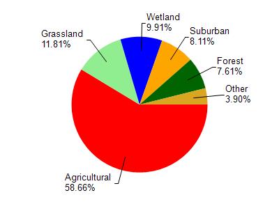
Koshkonong Creek is located in the Upper Koshkonong Creek watershed which is 104.25 mi². Land use in the watershed is primarily agricultural (58.60%), grassland (11.80%) and a mix of wetland (9.90%) and other uses (19.60%). This watershed has 176.17 stream miles, 157.76 lake acres and 6,145.17 wetland acres.
Nonpoint Source Characteristics
This watershed is ranked High for runoff impacts on streams, Medium for runoff impacts on lakes and High for runoff impacts on groundwater and therefore has an overall rank of High. This value can be used in ranking the watershed or individual waterbodies for grant funding under state and county programs.However, all waters are affected by diffuse pollutant sources regardless of initial water quality. Applications for specific runoff projects under state or county grant programs may be pursued. For more information, go to surface water program grants.