Waukesha
No
No
No
Fish and Aquatic Life
Overview
This 703-acre lake is a large elongated basin in the interlobate moraine. The bays
comprising the irregular shore are smaller adjoining basins. The lake is primarily spring-fed but receives some water from Beaver Lake's outflow in wetter years and has its own outflow to North Lake and Cornell Lake in wet seasons. The water is clear and the bottom is mostly gravel. The fishery includes panfish, largemouth bass, smallmouth bass, northern pike and walleye, with cisco providing a popular winter fishery.
The Pine Lake Association has not been active with any WDNR programs. The most recent activity on Pine Lake centers around the new public boat launch at the north end of the lake. Before completion of the launch and parking lot in late 1994, visiting boaters would have to park their cars more a quarter-mile away, then walk back to the launch.
In 1991, WDNR staff identified two sensitive areas on the lake. Management restrictions on these areas include bans on aquatic herbicide use, filling, pea gravel blankets, aquatic plant screens, and sea walls composed of concrete, timber or steel.
Zebra mussels have been identified in the watershed, but not in the lake. Pine Lake is most susceptible to these exotic invaders via boat transport.
Date 2002
Author Aquatic Biologist
Historical Description
Source: 1963, Surface Water Resources of Waukesha County
Pine Lake T8N, R18E
Surface Acres = 703, S.D.F. = 1.96, Maximum Depth = 85 feet
A large elongated basin in the interlobate moraine. The bays
which make up the irregular shore are in effect smaller adjoining
basins. The lake is primarily spring fed but receives some water
from Beaver Lake's outflow in "wet" years and has an outflow itself
to North Lake and Cornell Lake only in wet seasons. The water is
clear and the bottom is mostly gravel. The fishery consists of pan
fish, largemouth bass, northern pike, walleyes and cisco. The
latter provides for a popular winter fishery. Public access is
provided by a town road, however parking is prohibited within about
one-half mile of the access by ordinance of the Village of Chenequa
which encompasses this area. There are no adjoining wetlands of
importance to wildlife.
Date 1963
Author Surface Water Inventory Of Wisconsin
General Condition
Pine Lake (779200) was assessed during the 2016 listing cycle; total phosphorus and chlorophyll sample data were clearly below 2016 WisCALM listing thresholds for the Recreation use and Fish and Aquatic Life use. This water is meeting these designated uses and is not considered impaired.
Date 2015
Author Ashley Beranek
Condition
Wisconsin has over 84,000 miles of streams, 15,000 lakes and milllions of acres of wetlands. Assessing the condition of this vast amount of water is challenging. The state's water monitoring program uses a media-based, cross-program approach to analyze water condition. An updated monitoring strategy (2015-2020) is now available. Compliance with Clean Water Act fishable, swimmable standards are located in the Executive Summary of Water Condition in 2018. See also the 'monitoring and projects' tab.
Reports
Management Goals
Wisconsin's Water Quality Standards provide qualitative and quantitative goals for waters that are protective of Fishable, Swimmable conditions [Learn more]. Waters that do not meet water quality standards are considered impaired and restoration actions are planned and carried out until the water is once again fishable and swimmable
Management goals can include creation or implementation of a Total Maximum Daily Load analysis, a Nine Key Element Plan, or other restoration work, education and outreach and more. If specific recommendations exist for this water, they will be displayed below online.
Monitoring
Monitoring the condition of a river, stream, or lake includes gathering physical, chemical, biological, and habitat data. Comprehensive studies often gather all these parameters in great detail, while lighter assessment events will involve sampling physical, chemical and biological data such as macroinvertebrates. Aquatic macroinvertebrates and fish communities integrate watershed or catchment condition, providing great insight into overall ecosystem health. Chemical and habitat parameters tell researchers more about human induced problems including contaminated runoff, point source dischargers, or habitat issues that foster or limit the potential of aquatic communities to thrive in a given area. Wisconsin's Water Monitoring Strategy was recenty updated.
Grants and Management Projects
Monitoring Projects
| WBIC | Official Waterbody Name | Station ID | Station Name | Earliest Fieldwork Date | Latest Fieldwork Date | View Station | View Data |
|---|
| 779200 | Pine Lake | 683201 | Pine Lake - Deep Hole | 5/1/1979 | 6/9/2026 | Map | Data |
| 779200 | Pine Lake | 683144 | Pine Lake - Deep Hole | 9/18/1973 | 9/26/1995 | Map | Data |
| 779200 | Pine Lake | 10017618 | Pine Lake -- Access | 6/17/2005 | 6/4/2026 | Map | Data |
| 779200 | Pine Lake | 684011 | Pine Lake - Pine Lake | 9/4/1979 | 9/4/1979 | Map | Data |
| 779200 | Pine Lake | 10007174 | Pine Lake - T8 R18E S32 | 7/1/1978 | 9/2/2025 | Map | Data |
|
Watershed Characteristics
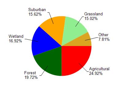
Pine Lake is located in the Oconomowoc River watershed which is 130.86 mi². Land use in the watershed is primarily agricultural (24.90%), forest (19.70%) and a mix of wetland (16.90%) and other uses (38.40%). This watershed has 136.99 stream miles, 2,858.66 lake acres and 11,105.19 wetland acres.
Nonpoint Source Characteristics
This watershed is ranked Not Available for runoff impacts on streams, Not Available for runoff impacts on lakes and High for runoff impacts on groundwater and therefore has an overall rank of High. This value can be used in ranking the watershed or individual waterbodies for grant funding under state and county programs.However, all waters are affected by diffuse pollutant sources regardless of initial water quality. Applications for specific runoff projects under state or county grant programs may be pursued. For more information, go to surface water program grants.