Details
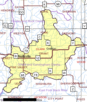
The O'Neill and Cunningham Creeks watershed, located in Clark County, is approximately 162 square miles. Neillsville and Granton contain the major populations in this watershed and consequently two of the three wastewater discharges. Low base flow and gradient as well as flashy flows during rain events characterize the streams in the O'Neill and Cunningham Creeks watershed. These conditions greatly influence the fisheries in these streams. All streams support at least a forage fishery. Some streams can support a sport fishery, if water levels are adequate. A majority of the original forested areas were converted to agricultural use. No lakes greater than ten acres exist within this watershed.
Date 1999

Ecological Landscapes
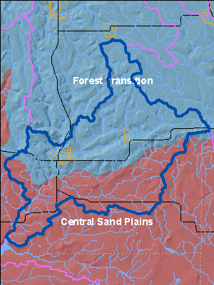
The O'Neill and Cunningham Creeks Watershed is located in both the Forest Transition ecological landscape and the Central Sand Plains ecological landscape.
The Forest Transition Ecological Landscape lies along the northern border of Wisconsin's Tension Zone, through the central and western part of the state, and supports both northern forests and agricultural areas. The central portion of the Forest Transition lies primarily on a glacial till plain deposited by glaciation between 25,000 and 790,000 years ago. The eastern and western portions are on moraines of the Wisconsin glaciation. The growing season in this part of the state is long enough that agriculture is viable, although climatic conditions are not as favorable as in southern Wisconsin. Soils are diverse, ranging from sandy loam to loam or shallow silt loam, and from poorly drained to well drained.
The historic vegetation of the Forest Transition was primarily northern hardwood forest. These northern hardwoods were dominated by sugar maple and hemlock, and contained some yellow birch, red pine and white pine. Currently, over 60% of this Ecological Landscape is non-forested. Forested areas consist primarily of northern hardwoods and aspen, with smaller amounts of oak and lowland hardwoods. The eastern portion of the Ecological Landscape differs from the rest of the area in that it remains primarily forested, and includes some ecologically significant areas. Throughout the Ecological Landscape, small areas of conifer swamp are found near the headwaters of streams, and associated with lakes in kettle depressions on moraines. Ground flora show characteristics of both northern and southern Wisconsin, as this Ecological Landscape lies along the Tension Zone.
The Central Sand Plains Ecological Landscape, located in central Wisconsin, occurs on a flat, sandy lake plain, and supports agriculture, forestry, recreation, and wildlife management. The Ecological Landscape formed in and around what was once Glacial Lake Wisconsin, which contained glacial meltwater extending over 1.1 million acres at its highest stage. Soils are primarily sandy lake deposits, some with silt-loam loess caps. Sandstone buttes carved by rapid drainage of the glacial lake, or by wave action when they existed as islands in the lake, are distinctive features of this landscape.
The historic vegetation of the area included extensive wetlands of many types, including open bogs, shrub swamps, and sedge meadows. Prairies, oak forests, savannas and barrens also occurred in the Ecological Landscape. An area of more mesic forest with white pine and hemlock was found in the northwest portion, including a significant pinery in eastern Jackson County. Today, nearly half of the Ecological Landscape is nonforested, in agriculture and grassland. Most of the historic wetlands were drained early in the 1900s and are now used for vegetable cropping. The forested portion is mostly oak-dominated forest, followed by aspen and pines. A minor portion is maple-basswood forest and lowland hardwoods.
Date 2010
Wildlife and Habitat
One aquatic dependent species of concern has been documented in this watershed. Management decisions should consider potential affects to these species. Other species may be present but not yet documented.
Date 1999
River and Stream QualityAll Waters in WatershedThe abundance of agricultural land use in this watershed is the likely cause of organic pollution in these streams. Macroinvertebrate sampling conducted in this watershed indicates a trend of improved water quality in the downstream portions of streams. The poor water quality documented in the upstream reaches may be caused by organic loading aggravated by low stream flow. Additional water volume further downstream may dilute this nutrient enriched water, which may result in improved water quality (Hazuga).
Date 1999
Watershed Trout StreamsWatershed Outstanding & Exceptional ResourcesLakes and Impoundments
Impaired Waters
List of Impaired Waters Watershed RecommendationsWI Rapids Storm Water Management Plan Update
Date
Status
This project is an installation of nonpoint source best management practices to contribute to the restoration of Wisconsin's waters and was funded by the 319 grant. Storm water planning activities will be undertaken by the municipality and will result in the following products: updated storm water management plan for the developed urban area.
1/1/2016
In Progress
Citizen Stream Monitoring
Date
Status
Collect chemical, physical, and/or biological water quality data to assess the current overall stream health. The data can inform management decisions and may be used to identify impaired waters for biennial lists.
1/1/2012
In Progress
Confirm FCA: IW pre-2000 data
Date
Status
1676700 name Black R. (Below Medford) TMDL ID 582 Start Mile 132.67 End Mile 168.4
11/21/2011
Proposed
Date
Status
WDNR staff should continue to encourage communities to develop wellhead protection plans in the Watershed and the whole basin.
7/1/2010
Proposed
Mead Lake TMDL
Date
Status
TMDL Development for Mead Lake in Clark County, WI. Mead Lake is highly eutrophic and exhibits excessive concentrations of phosphorus and chlorophyll (a measure of algal densities) in its surface waters during the summer months (USACE 2005). Sediment and phosphorus enters the lake via the South Fork Eau Claire River, from nonpoint sources of pollution.
7/1/2007
In Progress
Wisconsin Rapids, Wood County
Date
Status
SSA Planning and Updates for Wisconsin Rapids
4/1/2011
In Progress
 Watershed History Note
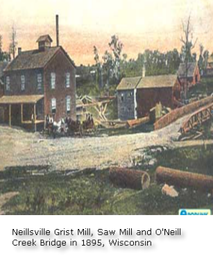
The Ojibwa were the earliest known residents of the Neillsville area. The first settlers of European decent in the area were James O'Neill and his party, who arrived around 1845, looking for a location to build a sawmill along the Black River. The city was named in honor of O'Neill, as was O'Neill Creek, which runs through the center of the city and drains into the Black River. In 1854, O'Neill's Mill, as Neillsville was originally called, was selected as the county seat of Clark County. Neillsville was platted on April 14, 1855 and incorporated in April 1882.
The High Ground is a veterans' memorial park located west of Neillsville. The Highground began in 1984 by Tom Miller as a Vietnam Veterans' memorial. Since then it has become a tribute to veterans of many wars, It now includes memorials to World War I and World War II veterans. It is a Veterans Memorial Park that pays tribute to the Dead, and honors the Survivors, their service, and their sacrifices. It also pays tribute to the people who supported them when they were away and upon their return.
Photo at right from ePodunk post cards are vintage images, dating from the early 1900s. They are not intended to depict current views
http://www.epodunk.com
Date 2010