Details
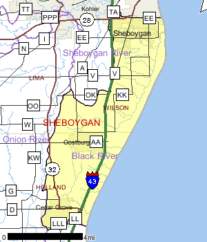
The entire Black River Watershed is located within Sheboygan County. The southern portion of the City of Sheboygan, most of the village of Cedar Grove and the entire Village of Oostburg are located in the watershed. The watershed encompasses 36 square miles and contains three named streams, the Black River, Barr Creek and Fisherman's Creek and 32 unnamed streams. There are no lakes or impoundments in the watershed.
Land uses in the watershed are mainly rural, characterized as natural lowlands with adjacent agricultural areas. Fisherman¿s Creek, which flows through the southern portion of the City of Sheboygan is characterized as urban.
Water quality in the watershed is considered poor. Rural and urban runoff, industrial and municipal point sources, channel modifications and construction site erosion all contribute to flashy flows, increased nutrients, bacteria, sedimentation and contaminated sediment.
Date 2001

Ecological Landscapes
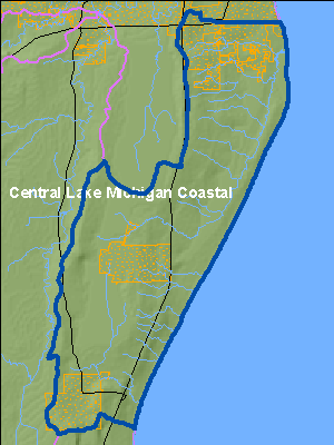
The Central Lake Michigan Coastal Ecological Landscape stretches from southern Door County west across Green Bay to the Wolf River drainage, then southward in a narrowing strip along the Lake Michigan shore to central Milwaukee County. Owing to the influence of Lake Michigan in the eastern part of this landscape, summers there are cooler, winters warmer, and precipitation levels greater than at locations farther inland. Dolomites and shales underlie the glacial deposits that blanket virtually all of the Central Lake Michigan Coastal Ecological Landscape. The dolomite Niagara Escarpment is the major bedrock feature, running across the entire landscape from northeast to southwest. Series of dolomite cliffs provide critical habitat for rare terrestrial snails, bats, and specialized plants. The primary glacial landforms are ground moraine, outwash, and lakeplain. The topography is generally rolling where the surface is underlain by ground moraine, variable over areas of outwash, and nearly level where lacustrine deposits are present. Important soils include clays, loams, sands, and gravels. Certain landforms, such as sand spits, clay bluffs, beach and dune complexes, and ridge and swale systems, are associated only with the shorelines of Lake Michigan and Green Bay.
Historically, most of this landscape was vegetated with mesic hardwood forest composed primarily of sugar maple, basswood, and beech. Hemlock and white pine were locally important, but hemlock was generally restricted to cool moist sites near Lake Michigan. Areas of poorly drained glacial lakeplain supported wet forests of tamarack, white cedar, black ash, red maple, and elm, while the Wolf and Embarrass Rivers flowed through extensive floodplain forests of silver maple, green ash, and swamp white oak. Emergent marshes and wet meadows were common in and adjacent to lower Green Bay, while Lake Michigan shoreline areas featured beaches, dunes, interdunal wetlands, marshes, and highly diverse ridge and swale vegetation. Small patches of prairie and oak savanna were present in the southwestern portion of this landscape.
Date 2010
Fisheries
Fish surveys conducted in 1994, 1999 and 2000 showed that a diverse fish community exists in the Black River with 10 forage fish and eight sport fish species in the lower reaches and fewer species in the upper reaches.
The Black River also supports a limited seasonal run of trout and salmon from Lake Michigan, providing some additional fishing opportunities for anglers.
Date 2001
Aquatic Invasive Species
Purple loosestrife infestations in the wetland areas are severely affecting the natural environment. This plant competes with the native vegetation in the wetland areas. The Jerving Conservancy, located near the mouth of the Black River was once a highly valued migratory bird site but is now degraded by purple loosestrife overgrowth.
Date 2001
Rivers and Streams
All Waters in WatershedWatershed Trout StreamsWatershed Outstanding & Exceptional ResourcesLakes and Impoundments
Impaired Waters
List of Impaired WatersWatershed RecommendationsSheboygan County Farm Nonpoint Source BMPs
Date
Status
This project is a landowner installation of nonpoint source best management practices to contribute to the restoration of Wisconsin's waters and was funded by the 319 grant.
3/13/2018
In Progress
Date
Status
WDNR should assist the county in identifying drain tile connections from septic systems and milk-house wastes to surface waters and facilitate the corrections.
1/1/2010
Proposed
City of Sheboygan Stormwater Management Plan Update
Date
Status
This project is an installation of nonpoint source best management practices to contribute to the restoration of Wisconsin?s waters and was funded by the 319 grant. Storm water planning activities will be undertaken by the municipality and will result in the following products: updated storm water management plan for the entire developed urban area; and an updated storm water management plan for new development.
1/1/2018
In Progress
City of Plymouth Stormwater Planning
Date
Status
This project is an installation of nonpoint source best management practices to contribute to the restoration of Wisconsin?s waters and was funded by the 319 grant. Storm water planning activities will be undertaken by the municipality and will result in the following products: new construction erosion control ordinance; new low impact development/conservation subdivision ordinance; new storm water ordinance for new development and re-development; other new ordinances that affect runoff from the developed urban area; and development and implementation of a new financing mechanism for funding the storm water program; and a new storm water management plan for the entire developed urban area.
1/1/2018
In Progress
River Basin Partnership Willow Creek
Date
Status
The impact of current and future land use on water quality conditions in Willow Creek are not well understood. Therefore, planning needs to be completed to help guide the types of BMP?s and management policies that will be needed to preserve and restore water quality and habitat in the watershed. The watershed plan can identify types of restoration and stream improvement projects that could be implemented.
12/21/2009
In Progress
 Water Plans and Partnerships
Date 2011
Watershed History NoteThe Villages of Cedar Grove and Oostburg in Sheboygan County are located in the Black River Watershed along the western shore of Lake Michigan. These villages have a strong link to the Netherlands. Between 1844 and 1880, religious intolerance, crop failures and rising prices led to thousands of Dutch citizens emigrating from the western part of the Netherlands to the United States. Sheboygan County was one of the four main areas in Wisconsin where they chose to settle.
Having achieved statehood in 1848, land was inexpensive in Wisconsin and the landscape was similar to back home. The abundance of timber provided a source of income while trying to build a homestead. Once land was cleared, it was suitable for different types of agriculture. Once settled, letters back to the home country would have encouraged others to make the move as well, thus swelling the ranks of the Dutch in certain areas.
Today the Dutch legacy can be seen in the windmills in the front yards, in the names of streets, and strong historical societies. The Village of Cedar Grove celebrates with the two-day Holland Festival every summer. Before the Saturday afternoon parade the main street is scrubbed by children and adults dressed in traditional Dutch costumes to prepare the road for the Klompen Dancers. Klompen, the traditional wooden shoes worn by the Dutch, are donned for dancing, street scrubbing and a children's race at the Holland Festival. The roomy wooden shoes were originally worn by the Dutch to work in the fields where they protected them from the cold and the moisture. Klomping down the street to accordion music is said to be reminiscent of Dutch ancestors congregating on old cobblestone streets to attend a village event or church gathering.
During the Holland Festival, residents of all ages take to the street in costume to participate in the ceremonial street scrubbing. Armed with "Old Dutch" cleanser, an assortment of brooms, and water from wooden barrels or buckets, they scrub the pavement until the Burgemeister (village president) declares it clean. Only then do the Klompen Dancers kick up their heels.
Date 2011