Green Lake
No
No
Yes
Fish and Aquatic Life
Overview
Little Green Lake, in the Upper Grand River Watershed, is a 462.41 acre lake that falls in Green Lake County. This lake is managed for fishing and swimming and is currently considered impaired.
Date 2011
Author Aquatic Biologist
Historical Description
Source: 1971, Surface Water Resources of Green Lake County
Little Green Lake, T-15-N, R-13-E, Sections 29, 32
Surface Acres = 466; S.D.F. = 1.39 Maximum Depth = 24 feet
Little Green Lake is also a very popular recreation lake.
Bottom materials consist of sand and muck, but some gravel and
rubble areas are also present. The water is clear, hard, and
subject to severe algae blooms. The lake is best known for
muskellunge and bluegill, but walleye, perch, and largemouth bass
are also present. Other fish include pumpkinseed, smallmouth bass,
and black bullheads. In addition to fishing the lake is used for
boating, sailing, water skiing, and swimming. The lake had some
problems in the past. Excessive algae and aquatic vegetation
growths have required chemical treatment. The decomposition of
algae blooms has caused major summerkills of fish. In 1956, the
lake was treated with toxaphene to remove the undesirable fish
population including carp and was subsequently restocked with its
present fishery. Since Little Green is heavily developed there is
a danger of valuable spawning areas and marshlands being destroyed
and cause severe and permanent damage to the quality of the lake.
Developments include two resorts and 125 dwellings. There are nine
boat liveries. Public access consists of Veteran's Park, developed
by the City of Markesan; two town access sites with parking and
boat ramps; and one town road providing walk-in access.
Date 1971
Author Surface Water Inventory Of Wisconsin
Impaired Waters
Little Green Lake (WBIC 162500) was placed on the impaired waters list for total phosphorus in 2006. The 2018 assessments showed continued impairment by phosphorus; new total phosphorus and chlorophyll-a sample data exceeded the 2018 WisCALM listing thresholds for the Recreation use and Fish and Aquatic Life use. Based on the most updated information, no change in existing impaired waters listing was needed.
Date 2017
Author Ashley Beranek
Impaired Waters
Little Green Lake (162500) was placed on the impaired waters list for total phosphorus in 2006. The 2016 assessments showed continued impairment by phosphorus; total phosphorus sample data exceed 2016 WisCALM listing thresholds for the Recreation use, but not Fish and Aquatic Life use, and chlorophyll data exceeds both REC and FAL thresholds. Based on the most updated information, no change in existing impaired waters listing is needed.
Date 2015
Author Aaron Larson
Condition
Wisconsin has over 84,000 miles of streams, 15,000 lakes and milllions of acres of wetlands. Assessing the condition of this vast amount of water is challenging. The state's water monitoring program uses a media-based, cross-program approach to analyze water condition. An updated monitoring strategy (2015-2020) is now available. Compliance with Clean Water Act fishable, swimmable standards are located in the Executive Summary of Water Condition in 2018. See also the 'monitoring and projects' tab.
Reports
Recommendations
Land Acquisition
The Little Green Lake Protection & Rehabilitation District proposes to purchase 45.61 acres of land known as the Scharschmidt property to help prevent nutrient loading into Little Green Lake.
Habitat Restoration - Lake
The Little Green Lake Protection & Rehabilitation District proposes to install a circulation system consisting of compressors, air delivery lines, filter system, and a housing structure. The circulation system is designed to ensure sufficient oxygen concentrations in the deep-water areas of the lake.
Best Management Practices, Implement
The Little Green Lake Protection & Rehabilitation District proposes to design and construct three water and sediment control basins in the east subwatershed of Little Green Lake.
Shoreland Monitoring, Assessment, Inventory
Green Lake County will conduct a land use and environmental resource inventory of the watershed surrounding Green Lake, Little Green Lake, and Lake Puckaway. The information from the study will be used to update the existing zoning and shoreland protection ordinances and to assess the need for a storm water management ordinance in the County, the stormwater management ordinance, if its need is determined, will be written
Management Goals
Wisconsin's Water Quality Standards provide qualitative and quantitative goals for waters that are protective of Fishable, Swimmable conditions [Learn more]. Waters that do not meet water quality standards are considered impaired and restoration actions are planned and carried out until the water is once again fishable and swimmable
Management goals can include creation or implementation of a Total Maximum Daily Load analysis, a Nine Key Element Plan, or other restoration work, education and outreach and more. If specific recommendations exist for this water, they will be displayed below online.
Monitoring
Monitoring the condition of a river, stream, or lake includes gathering physical, chemical, biological, and habitat data. Comprehensive studies often gather all these parameters in great detail, while lighter assessment events will involve sampling physical, chemical and biological data such as macroinvertebrates. Aquatic macroinvertebrates and fish communities integrate watershed or catchment condition, providing great insight into overall ecosystem health. Chemical and habitat parameters tell researchers more about human induced problems including contaminated runoff, point source dischargers, or habitat issues that foster or limit the potential of aquatic communities to thrive in a given area. Wisconsin's Water Monitoring Strategy was recenty updated.
Grants and Management Projects
Monitoring Projects
| WBIC | Official Waterbody Name | Station ID | Station Name | Earliest Fieldwork Date | Latest Fieldwork Date | View Station | View Data |
|---|
| 162500 | Little Green Lake | 10041138 | Little Green Lake edge of Northern Bay | 8/21/1997 | 8/21/1997 | Map | Data |
| 162500 | Little Green Lake | 10002699 | Little Green Lake | 6/1/1993 | 10/1/2025 | Map | Data |
| 162500 | Little Green Lake | 10033612 | Little Green Lake - LakeView Bay | 8/21/1997 | 7/21/2014 | Map | Data |
| 162500 | Little Green Lake | 10041130 | Little Green Lake Site 10 | 8/21/1997 | 8/21/1997 | Map | Data |
| 162500 | Little Green Lake | 10061149 | Little Green Lake LMP Transect Point 10 | 5/20/2026 | 6/25/2026 | Map | Data |
| 162500 | Little Green Lake | 10061148 | Little Green Lake LMP Transect Point 9 | 5/20/2026 | 6/25/2026 | Map | Data |
| 162500 | Little Green Lake | 10041135 | Little Green Lake Southeastern Bay | 8/21/1997 | 8/21/1997 | Map | Data |
| 162500 | Little Green Lake | 10061146 | Little Green Lake LMP Transect Point 7 | 5/20/2026 | 6/25/2026 | Map | Data |
| 162500 | Little Green Lake | 10041123 | Little Green Lake Kearlys Bay 2 | 8/21/1997 | 8/21/1997 | Map | Data |
| 162500 | Little Green Lake | 243037 | Little Green Lake at Center Near Markesan WI | 8/27/1992 | 4/22/2026 | Map | Data |
| 162500 | Little Green Lake | 10061140 | Little Green Lake LMP Transect Point 1 | 5/20/2026 | 6/25/2026 | Map | Data |
| 162500 | Little Green Lake | 10033613 | Little Green Lake - Kearley Bay | 7/20/2000 | 8/17/2014 | Map | Data |
| 162500 | Little Green Lake | 10041133 | Little Green Lake Southwest Bay near Island | 8/21/1997 | 8/21/1997 | Map | Data |
| 162500 | Little Green Lake | 10019275 | Little Green Lake -- Kearley Bay Access | 6/28/2005 | 1/27/2025 | Map | Data |
| 162500 | Little Green Lake | 10061232 | Little Green Lake Staff Gauge 1 | | | Map | Data |
| 162500 | Little Green Lake | 10061144 | Little Green Lake LMP Transect Point 5 | 5/20/2026 | 6/25/2026 | Map | Data |
| 162500 | Little Green Lake | 10061142 | Little Green Lake LMP Transect Point 3 | 5/20/2026 | 6/25/2026 | Map | Data |
| 162500 | Little Green Lake | 10033854 | Little Green Lake -- Lakeview Inn - Private Access | 6/8/2011 | 6/8/2011 | Map | Data |
| 162500 | Little Green Lake | 10041126 | Little Green Lake near Kearlys Bay | 8/21/1997 | 8/21/1997 | Map | Data |
| 162500 | Little Green Lake | 10041129 | Little Green Lake Site 9 | 8/21/1997 | 8/21/1997 | Map | Data |
| 162500 | Little Green Lake | 10061145 | Little Green Lake LMP Transect Point 6 | 5/20/2026 | 6/25/2026 | Map | Data |
| 162500 | Little Green Lake | 10041124 | Little Green Lake Kearlys Bay 3 | 8/21/1997 | 8/21/1997 | Map | Data |
| 162500 | Little Green Lake | 10041136 | Little Green Lake Northern Bay | 8/21/1997 | 8/21/1997 | Map | Data |
| 162500 | Little Green Lake | 10033610 | Little Green Lake - Muskie Bay | 10/9/2010 | 7/21/2014 | Map | Data |
| 162500 | Little Green Lake | 10033994 | Little Green Lake - Central South | 5/16/2000 | 6/12/2003 | Map | Data |
| 162500 | Little Green Lake | 10041122 | Little Green Lake Kearlys Bay near northern shore | 8/21/1997 | 8/21/1997 | Map | Data |
| 162500 | Little Green Lake | 10041137 | Little Green Lake Northern Bay | 8/21/1997 | 8/21/1997 | Map | Data |
| 162500 | Little Green Lake | 10061141 | Little Green Lake LMP Transect Point 2 | 5/20/2026 | 6/25/2026 | Map | Data |
| 162500 | Little Green Lake | 243022 | Little Green Lake - Deep Hole (central east) | 8/4/1986 | 6/25/2026 | Map | Data |
| 162500 | Little Green Lake | 10061147 | Little Green Lake LMP Transect Point 8 | 5/20/2026 | 6/25/2026 | Map | Data |
| 162500 | Little Green Lake | 10061143 | Little Green Lake LMP Transect Point 4 | 5/20/2026 | 6/25/2026 | Map | Data |
| 162500 | Little Green Lake | 10033995 | Little Green Lake - Central West | 5/16/2000 | 8/31/2000 | Map | Data |
| 162500 | Little Green Lake | 10041132 | Little Green Lake Southwest Bay | 8/21/1997 | 8/21/1997 | Map | Data |
| 162500 | Little Green Lake | 10041134 | Little Green Lake Southeastern Bay by shore | 8/21/1997 | 8/21/1997 | Map | Data |
| 162500 | Little Green Lake | 10033851 | Little Green Lake -- Vandy's Lakeside Pub and Motel - Private Access | 6/8/2011 | 6/8/2011 | Map | Data |
| 162500 | Little Green Lake | 10019478 | Little Green Lake -- Lake Shore Drive Access | 5/28/2010 | 7/28/2018 | Map | Data |
| 162500 | Little Green Lake | 10041139 | Little Green Lake near edge of Southeastern Bay | 8/21/1997 | 8/21/1997 | Map | Data |
| 162500 | Little Green Lake | 10019276 | Little Green Lake -- Access | 8/17/2008 | 1/27/2025 | Map | Data |
| 162500 | Little Green Lake | 10041131 | Little Green Lake Site 11 | 8/21/1997 | 8/21/1997 | Map | Data |
| 162500 | Little Green Lake | 10033993 | Little Green Lake - Central North | 5/16/2000 | 8/31/2000 | Map | Data |
| 162500 | Little Green Lake | 10033850 | Little Green Lake -- The Landing - Private Access | 6/8/2011 | 8/4/2014 | Map | Data |
| 162500 | Little Green Lake | 10041127 | Little Green Lake Site 6 | 8/21/1997 | 8/21/1997 | Map | Data |
| 162500 | Little Green Lake | 10041128 | Little Green Lake Site 8 | 8/21/1997 | 8/21/1997 | Map | Data |
| 162500 | Little Green Lake | 10041125 | Little Green Lake edge of Kearlys Bay | 8/21/1997 | 8/21/1997 | Map | Data |
|
Watershed Characteristics
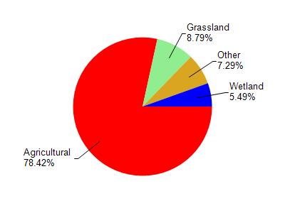
Little Green Lake is located in the Upper Grand River watershed which is 61.96 mi². Land use in the watershed is primarily agricultural (78.50%), grassland (8.80%) and a mix of wetland (5.50%) and other uses (7.30%). This watershed has 85.07 stream miles, 41.45 lake acres and 2,973.87 wetland acres.
Nonpoint Source Characteristics
This watershed is ranked Medium for runoff impacts on streams, Not Ranked for runoff impacts on lakes and High for runoff impacts on groundwater and therefore has an overall rank of High. This value can be used in ranking the watershed or individual waterbodies for grant funding under state and county programs.This water is ranked High Lake for individual Lakes based on runoff problems and the likelihood of success from project implementation.