Polk, St. Croix
No
No
Yes
Fish and Aquatic Life
Overview
The lake is located within
the St. Croix River drainage basin and geographically spans Sections 34 and 35, T32N, R
18W - Polk county and Sections 2 and 3, T31-32 N R18W in St. Croix county on the
New Richmond North USGS quadrangle. Cedar Lake is listed on the Wisconsin
Department of Natural Resources’ (WDNR) 1998 303(d) List of Impaired Waters. The
Lake is nutrient (phosphorus (P)) impaired as a result of agriculture, internal loading and
local land use, is listed as a medium priority water with external load sources are
nonpoint source (NPS) dominating. The designated use for Cedar Lake is defined as a
full recreation, warm water sport fishery water. For additional detailed information on
the watershed relevant to the TMDL see the Nonpoint Source Pollution Control Plan for
the Horse Creek Priority Watershed Project dated June 2001 (Attachment 1).
Water quality in Cedar Lake is generally poor to very poor, falling into the eutrophic to
hypereutrophic category (see Cedar Lake - Management Plan, Polk and St. Croix
Counties, page 3) dated 1989 (Attachment 2). Summer (1986-2001) surface water
column total phosphorus levels average 83 ug/l. Summer algal blooms result in foul
odors and an unsightly build-up of algae biomass on the shoreline. In addition, trophic
conditions in the lake limit rooting depth for emergent vegetation used by the resident
fish populations. As a result, these impairments impact the recreational/aesthetic value of
the lake and stress sport fish populations.
This criterion describes the acceptable water quality conditions and guides the WDNR in
setting a numerical target pollutant concentration. The application of a narrative criterion
for Cedar Lake necessitates the development of a site-specific in-water value for the
purpose of this TMDL.
The site-specific eplimnetic total phosphorus concentration goal has been identified as 50
ug/L. The in-lake TP concentration represents the mean growing season (GSM)
eplimnetic concentration. This narrative criterion is based on a comparison with similar
lake types in the area taking into account site-specific conditions, using available
monitoring data and modeling tools. The receiving water capacity in this situation
represents cleaning-up the waterbody to achieve attainable uses.1 Based on a 2001
growing season (June/September) mean total phosphorus concentration of 100 ug/l,
Cedar Lake is hypereutrophic. Specifically, the intent is to minimize the frequency of
algal blooms and reduce nuisance conditions in the lake. The chlorophyll-a concentration
in Cedar Lake responds directly to the in-lake phosphorus concentration. Cedar Lake is
phosphorus limited based on a TN/TP ratio of 25. Lakes with ratios above 10 are
considered to be phosphorus limited. As P concentration rises, the chlorophyll-a
concentration rises and algal biomass production increases. This cause and effect
relationship is measured using a Secchi disk to measure water clarity (poor water clarity
results in limited emergent vegetation rooting depth and indicates the presence of
significant biomass in the water column). Reducing P reduces chlorophyll-a, which
results in improved water clarity and diminished algae production.
Date 2002
Author Aquatic Biologist
Historical Description
Cedar Lake has a long history of nuisance algal blooms which have been documented since the
1930's. Copper sulphate was used from the 1940's until mid-1980's. The citizens around Cedar
Lake formed the Cedar Lake Protection and Rehabilitation District to work towards improving
lake water quality. A 1977 feasibility study indicated that the watershed was a major source of
nutrients to the lake but that internal nutrient recycling within the lake was also a significant
source of phosphorus.
A comprehensive lake management plan was developed by the Department in 1989 in
cooperation with the lake district. The plan conducted a detailed assessment of the internal
nutrient recycling. This assessment concluded that internal nutrient recycling may be
contributing over 70% of the annual phosphorus load and be largely responsible for the
frequent summer algal blooms. Currently Water Resources Research is conducting a summer
aeration project evaluating the ability of aeration to control the recycling of phosphorus from
the anoxic lake sediments.
Date 1992
Author Surface Water Inventory Of Wisconsin
Historical Description
Source: 1961, Surface Water Resources of Polk County Cedar Lake T32N, R18W, Sec. 26, 27, 34, 35, 2, 3 Surface Acres = 1,107.0, S.D.F. = 1.42, Maximum Depth = 28 ft., M.P.A.=125 Situated partly in St. Croix County, it has a navigable inlet and outlet, Horse Creek. Muskellunge, walleyes, northern pike, largemouth bass, bluegills, black crappies, perch, pumpkinseed and bullheads are present. Public frontage on the lake consists of a 48.5-foot wide access road with a limited parking area. Private development includes three resorts, one boat livery and 93 cottages, developing 60 per cent of the shore line. Nineteen acres of marsh wetlands border the bay on the southwest. Nesting waterfowl includes bluewing teal and coots. Migratory waterfowl use is made mainly by diving ducks and Canada geese, with lesser numbers of puddle ducks, coots and whistling swans.
Date 1961
Author Surface Water Inventory Of Wisconsin
Impaired Waters
Cedar Lake (WBIC 2615100) was placed on the impaired waters list for total phosphorus in 1998. The phosphorus TMDL was approved by the U.S. EPA in 2003. The 2018 assessments showed continued impairment by phosphorus; new total phosphorus and chlorophyll-a sample data exceeded the 2018 WisCALM listing thresholds for the Recreation use and Fish and Aquatic Life use. Based on the most updated information, no change in the existing impaired waters listing was needed.
Date 2017
Author Ashley Beranek
Impaired Waters
Cedar Lake (2615100) was placed on the impaired waters list for total phosphorus in 1998. The phosphorus TMDL was approved by the U.S. EPA in 2003. The 2016 assessments showed continued impairment by phosphorus; total phosphorus sample data overwhelmingly exceed 2016 WisCALM listing thresholds for the Recreation use, and chlorophyll data exceed REC thresholds. Total phosphorus and chlorophyll data do not exceed Fish and Aquatic Life thresholds. Based on the most updated information, the FAL impairment indicator of Eutrophication was removed. This water will remain listed for Total Phosphorus.
Date 2015
Author Aaron Larson
Condition
Wisconsin has over 84,000 miles of streams, 15,000 lakes and milllions of acres of wetlands. Assessing the condition of this vast amount of water is challenging. The state's water monitoring program uses a media-based, cross-program approach to analyze water condition. An updated monitoring strategy (2015-2020) is now available. Compliance with Clean Water Act fishable, swimmable standards are located in the Executive Summary of Water Condition in 2018. See also the 'monitoring and projects' tab.
Reports
Recommendations
Monitor Paleocore
One sediment core was taken in Cedar Lake in 1997. Diatom analysis was done.
Monitor Pre and Post Treatment
The Cedar Lake P&RD proposes to apply an initial Alum treatment to Cedar Lake in St. Croix County to reduce phosphorus loading from in-lake sediments, thereby reducing algal blooms and allowing for restoration of the lake's native plant community. Major project elements to include a) Initial alum treatment, b) monitoring, and c) final report.
Best Management Practices, Implement
Cedar Lake P&RD applied an initial alum treatment to Cedar Lake in St. Croix County to reduce phosphorus loading from in-lake sediments, thereby reducing algal blooms and allowing for restoration of the lake's native plant community.
Lake Management Plan Development
Lakes Protection Grant
Cedar Lake PRD proposes to contract with the U.S. Army Corps of Engineers to conduct a study of Phosphorus (P) loading within Cedar Lake in St. Croix County. Major project elements to include 1) sediment sampling and analysis, 2) water quality sampling and analysis, 3) algae collection and analysis, 4) Lake modeling, 5) study of phosphorus loading, 6) studies of aeration and alum treatment as means of controlling internal loading, 7) comprehensive watershed ag land use assessment, 8) Final report.
Best Management Practices, Implement
This project promotes nonpoint source best management practices to contribute to the restoration of Wisconsin?s waters and was funded by the 319 grant. Specifically, the grantee will implement projects relating to: sheet, rill, and wind erosion; phosphorus index; manure storage facilities-new/significant alterations; manure storage facilities-closure; manure storage facilities-existing failing/leaking; process wastewater handling; nutrient management; prevention of overflow from manure storage facilities; prevention of unconfined manure piles in water quality management; prevention of direct runoff from a feedlot or stored manure into waters of the state; prevention of unlimited livestock access to waters of the state; and remedy discharges of manure, sediment and phosphorus in runoff entering waters of the state.
TMDL Development
The Wisconsin Department of Natural Resources (WDNR) developed a TMDL for phosphorus for Cedar Lake. The TMDL addresses the nutrient impacts and impairments which were identified on the Wisconsin 2002 303(d) list. The Lake is nutrient (phosphorus (P)) impaired as a result of agriculture, internal loading and local land use. Water quality in Cedar Lake is generally poor to very poor, falling into the eutrophic to hypereutrophic category. Summer algal blooms result in foul odors and an unsightly build-up of algae biomass on the shoreline. In addition, trophic conditions in the lake limit rooting depth for emergent vegetation used by the resident fish populations. As a result, these impairments impact the recreational/aesthetic value of the lake and stress sport fish populations.
TMDL (USEPA) Approved
The Cedar Lake (WBIC: 2615100) TMDL required widespread BMP implementation through the Horse Creek Lakes priority watershed project and whole lake mixing by aeration. This project will assess watershed phosphorus loadings and the three major sources of internal loadings.
TMDL Development
Cedar Lake (2615100) TMDL Development addressing nutrient impacts and impairments which
were identified on the Wisconsin 2002 303(d) list.
TMDL Implementation
Cedar Lake (2615100) TMDL Implementation addressing nutrient impacts and impairments which were identified on the Wisconsin 2002 303(d) list. The Cedar Lake TMDL required widespread BMP implementation through the Horse Creek Lakes priority watershed project and whole lake mixing by aeration.
Management Goals
Wisconsin's Water Quality Standards provide qualitative and quantitative goals for waters that are protective of Fishable, Swimmable conditions [Learn more]. Waters that do not meet water quality standards are considered impaired and restoration actions are planned and carried out until the water is once again fishable and swimmable
Management goals can include creation or implementation of a Total Maximum Daily Load analysis, a Nine Key Element Plan, or other restoration work, education and outreach and more. If specific recommendations exist for this water, they will be displayed below online.
Watershed Characteristics
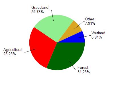
Cedar Lake is located in the Lower Apple River watershed which is 202.16 mi². Land use in the watershed is primarily forest (31.20%), agricultural (28.20%) and a mix of grassland (25.70%) and other uses (14.80%). This watershed has 151.64 stream miles, 4,391.99 lake acres and 9,095.80 wetland acres.
Nonpoint Source Characteristics
This watershed is ranked High for runoff impacts on streams, Medium for runoff impacts on lakes and High for runoff impacts on groundwater and therefore has an overall rank of High. This value can be used in ranking the watershed or individual waterbodies for grant funding under state and county programs.This water is ranked High Lake for individual Lakes based on runoff problems and the likelihood of success from project implementation.