Vilas
No
No
No
Fish and Aquatic Life
Overview
Little St Germain Lake, in the Sugar Camp Creek Watershed, is a 971.67 acre lake that falls in Vilas County. This lake is managed for fishing and swimming and the North and East lobes are currently considered impaired.
Date 2020
Author Ashley Beranek
Historical Description
Source: 1963, Surface Water Resources of Vilas County St. Germain (Little) Lake, T-40-N, R-8-E, Sections 26, 26, 34 and 35,
Little St. Germain Lake is a moderately fertile drainage lake. It has slightly alkaline, clear water of moderate transparency. The bottom material consists mostly of sand, with gravel, rock and some muck. Both the inlet and the outlet streams are considered to be navigable water. A 5-foot high dam maintains water levels, and the upper 1 foot-10 inches is used for water storage and low flow augmentation of the Wisconsin River. The principal fish species present in the lake are muskellunge, northern pike, walleye, largemouth bass and pan fish. The lake has several prominent use problems. The lake has a summerkill condition, which may result from algae following a series of cloudy days. The lake also suffers from an aquatic weed nuisance problem and weeds in some areas are a problem to navigation. The lake also suffers from a slow-growing pan fish population. There is public access available to Little St. Germain Lake but with very limited parking facilities, as well as by navigable water. There are 46 resorts located on Little St. Germain Lake and there are also two boat rental places. There are 103 cottages located on or about the shore line. Muskrats are considered a significant fur bearer in some of the marshy bays. The lake is of value for puddle ducks, diving ducks, coots and Canada geese on the fall migration. It is rather a popular hunting area for diving ducks in the fall. The lake does not have much wild shore line due to the intensive development of the shore line.
Area = 956 Surface Acres, Maximum Depth 56 feet
Date 1963
Author Surface Water Inventory Of Wisconsin
Impaired Waters
Little Saint Germaine Lake was recently evaluated during the ten-year period of 2009 through 2018 for results that were reported to the USEPA for the 2020 Clean Water Act condition report. The waterbody is considered impaired, or in poor condition for designated uses which include the quality of fish and aquatic life, recreational use, and public health and welfare (fish consumption and related). Pollutants or problems encountered during sampling (impairments) are determined based on water quality standards outlined in Wisconsin 2020 Consolidated Assessment and Listing Methodology (WisCALM). Assessment results show water conditions that are potentially harmful for Aquatic Life and Recreation uses due to values for total phosphorus that fall into the range expected for an aquatic community in poor health, therefore this water is listed as impaired.
North and East Lobes: Assessment results during the 2020 listing cycle show impairment by total phosphorus. Phosphorus levels were too high as evidenced by excess algal growth and eutrophication. Based on the most updated information, this portion of the lake was proposed for the impaired waters list in 2020.
West and South Lobes: The most recent assessments show these portions of the lake are in good condition.
Central Basin: The most recent assessments show the central basin of the lake is suspected to be in poor condition.
Date 2019
Author Ashley Beranek
Condition
Wisconsin has over 84,000 miles of streams, 15,000 lakes and milllions of acres of wetlands. Assessing the condition of this vast amount of water is challenging. The state's water monitoring program uses a media-based, cross-program approach to analyze water condition. An updated monitoring strategy (2015-2020) is now available. Compliance with Clean Water Act fishable, swimmable standards are located in the Executive Summary of Water Condition in 2018. See also the 'monitoring and projects' tab.
Reports
Recommendations
APM Chemical Permit Request
The purpose of this study is to do more intensive sampling of the sediment pore water and the sediment itself right after a herbicide treatment.
Monitor Water Quality or Sediment
The purpose of this study is to do more intensive sampling of the sediment pore water and the sediment itself right after a herbicide treatment.
Protect Riparian or Shorelands
Little St. Germain Lake P&R District is sponsoring a project focused on restoring 500 meters of shoreline on Lt. St. Germain Lake. Partners include the USGS, VCLA, Vilas Co. LWCD, UW Ext., WDATCP, MI Tech Univ., & WDNR.
Lakes Protection Grant
The Little St. Germain Lake Protection and Rehabilitation District is sponsoring a project involving the installation of two lake aerators for improvement of the winter lake dissolved oxygen levels, development of a preliminary engineering work scope for reduction of phosphorus loading to Little St. Germain Lake, and monitoring of inlake water chemistry, Muskellunge Creek monitoring, and groungwater monitoring to be conducted by the USGS.
County Land and Water Management Plan
Town of St. Germain proposes an extensive land and water resource protection program that includes the areas in and around Big and Little St. Germain, Lost Lake and other area water resources. This project will be a broad based long term cooperative planning effort involving the St. Germain Planning Committee, town officials, UW-Extension office and concerned citizens.
Management Goals
Wisconsin's Water Quality Standards provide qualitative and quantitative goals for waters that are protective of Fishable, Swimmable conditions [Learn more]. Waters that do not meet water quality standards are considered impaired and restoration actions are planned and carried out until the water is once again fishable and swimmable
Management goals can include creation or implementation of a Total Maximum Daily Load analysis, a Nine Key Element Plan, or other restoration work, education and outreach and more. If specific recommendations exist for this water, they will be displayed below online.
Monitoring
Monitoring the condition of a river, stream, or lake includes gathering physical, chemical, biological, and habitat data. Comprehensive studies often gather all these parameters in great detail, while lighter assessment events will involve sampling physical, chemical and biological data such as macroinvertebrates. Aquatic macroinvertebrates and fish communities integrate watershed or catchment condition, providing great insight into overall ecosystem health. Chemical and habitat parameters tell researchers more about human induced problems including contaminated runoff, point source dischargers, or habitat issues that foster or limit the potential of aquatic communities to thrive in a given area. Wisconsin's Water Monitoring Strategy was recenty updated.
Grants and Management Projects
Monitoring Projects
| WBIC | Official Waterbody Name | Station ID | Station Name | Earliest Fieldwork Date | Latest Fieldwork Date | View Station | View Data |
|---|
| 1596300 | Little Saint Germain Lake | 10005977 | Little St Germain Lake | 7/27/1999 | 9/30/2017 | Map | Data |
| 1596300 | Little Saint Germain Lake | 10033930 | Little St. Germain Lake -- Private Access - NW | 6/15/2011 | 6/15/2011 | Map | Data |
| 1596300 | Little Saint Germain Lake | 643504 | Little St Germain Lake - Site Kk | | | Map | Data |
|
Watershed Characteristics
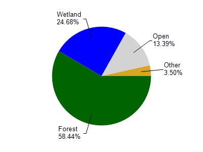
Little Saint Germain Lake is located in the Sugar Camp Creek watershed which is 187.99 mi². Land use in the watershed is primarily forest (58.50%), wetland (24.70%) and a mix of open (13.40%) and other uses (3.50%). This watershed has 123.61 stream miles, 11,669.73 lake acres and 30,139.17 wetland acres.
Nonpoint Source Characteristics
This watershed is ranked Not Ranked for runoff impacts on streams, Medium for runoff impacts on lakes and Low for runoff impacts on groundwater and therefore has an overall rank of Low. This value can be used in ranking the watershed or individual waterbodies for grant funding under state and county programs.However, all waters are affected by diffuse pollutant sources regardless of initial water quality. Applications for specific runoff projects under state or county grant programs may be pursued. For more information, go to surface water program grants.