Dodge
No
No
No
Fish and Aquatic Life
Overview
Sinissippi Lake is a 2,855-acre impoundment of the Rock River in Dodge County. Historically, this was a rapids area of the Rock River before the stretch was dammed. The lake has a maximum depth of 8 feet, with an average depth of 4.5 feet. It is a shallow eutrophic to hypereutrophic lake and supports multiple uses. Its drainage area is about 511 square miles. Because it is an impoundment with a large drainage area, it has water quality problems associated with impoundments in southern Wisconsin. These problems are turbidity, decreased habitat and periodic decreased DO levels (Eagan, 1989). Most of these problems are caused by polluted runoff in its drainage area. Heavy stormwater runoff due to intense farming and the loss of wetlands has increased soil erosion, sediment, and nutrient delivery to the lake. Excessive rough fish populations also afflict the lake. The fishery is now dominated by carp and bullhead, although there is a moderate population of walleye and a small population of northern pike. The lakeshore is significantly developed like most other lakes in southern Wisconsin. However, large stretches of lake shore remain undeveloped. In 1999, a pair of Bald eagles established a nest on lake shore property and sucessfully raised young in 2001.
The increased number of power boats on the lake and the Rock River immediately above the lake may also be causing water quality problems by resuspending fine bottom sediments and causing bank erosion. The lake could be a valuable migration stop for waterfowl. However, intensive use limits hunting opportunities.
In 2000, the Lake Sinissippi Management District was formed. The District has developed a comprehensive lake management plan with various management components to implement over the next five years. In 2001, the Lake Sinissippi Lake Improvement Association received a Lakes Protection Grant to monitor nutrient and sediment loading to the lake from the Rock River and Dead Creek. Another monitoring station will monitor the water quality leaving the lake at Hustisford. The monitoring will complement earlier, similar water quality monitoring conducted at Horicon and Hustisford by the Lake Sinnissippi Association, the Rock River Partnership, the Rock River Headwaters, the Village of Hustisford and the Town of Hubbard.
Date 2002
Author Aquatic Biologist
Historical Description
A large, shallow impoundment of the Rock River, created by a 12-foot dam at Hustisford. Known as Hustis' Rapids, the site was considered the finest waterpower on the river between Mayville and Rockford, Illinois. The original dam was erected in 1845. The lake flooded a sprawling, marshy valley and the numerous drumlins form peninsulas and islands as well as portions of the shoreline. The nearly level, peat bottomed depression did not lend itself to the formation of a deep reservoir and subsequent siltation from the watershed coupled with deposition from deteriorating marshes contributed to the shallowness. In 1939, the dam was raised, and water levels increased by 1.43 feet. This resulted in further breakup of the marshes. Today silt is the predominant bottom material and the lake varies between 3 and 4 feet in depth.
The shallow, fertile environment proved well suited for carp, and in 1939 the Wisconsin Conservation Department installed a fish trap on the Rock River north of the main body of the lake to control the population. The water is usually turbid and heavy algae blooms are a common occurrence. Because the lake is fed from Horicon Marsh waters poor in oxygen, winterkills are the rule and seldom does a winter pass without at least a partial kill. Addition of nutrients from sewage plants located within the immediate drainage area adds to the previously mentioned problems. The fishery consists mainly of carp, bullheads and northern pike, the latter species providing excellent fishing upon occasion. Large size and tendency to freeze-out makes the lake very difficult to manage, and fishing is spotty due to natural fluctuations. Exchange of fish populations occur with both the Horicon Marsh and the river below Hustisford. During the spring migration large numbers of waterfowl visit the lake, and at times 3,000 ducks,5,000 geese, and 500 swans have been observed. Lesser numbers stop in autumn, and heavy hunting pressure soon drives most of the birds to the Horicon Marsh.
The 2,300 acre lake has great potential for boating, and boating use has increased rapidly in recent years. Swimming conditions are poor due to the depth and quality of the water, algae, and soft bottom. A boat ramp located near the dam in a Hustisford park provides access, although parking is limited. Many boaters put in at either of two parks in Horicon and cruise the 4-mile stretch of the river to the lake. Hundreds of cottages and homes are located on the 17 miles of shoreline, and recent large-scale developments have added many to those already present. Extensive marshes remain along the north and west shores, and still produce significant numbers of muskrat and waterfowl.
The problems of siltation and pollution may someday be relieved, and a selective poison will provide a means of controlling the rough fish. Winterkill potential will always remain, a result of physical limitations alone. A complete drawdown has been suggested to expose the muck and enhance bottom compaction and oxidation of vegetative growth. Conflict of interest between hunter, fisherman, boater and cottage owner makes planning of solutions difficult under present conditions. Source: 1965, Surface Water Resources of Dodge County Sinissippi Lake T10, 11N, R16E Surface Acres = 2,300, S.D.F. = 2.53, Maximum Depth = 5 feet
Date 1965
Author Surface Water Inventory Of Wisconsin
Impaired Waters
Sinissippi Lake (WBIC 859900) was placed on the impaired waters list in 2006 for total phosphorus and sediment/total suspended solids. The TMDL for both of these pollutants was approved by the U.S. EPA in 2011. The 2018 assessments showed continued impairment by phosphorus; new total phosphorus and chlorophyll-a sample data exceeded the 2018 WisCALM listing thresholds for the Recreation use and Fish and Aquatic Life use. Based on the most updated information, no change in the existing impaired waters listing was needed.
Date 2017
Author Ashley Beranek
Impaired Waters
Sinissippi Lake (859900) was placed on the impaired waters list in 2006 for total phosphorus and sediment/total suspended solids. The TMDL for both of these pollutants was approved by the U.S. EPA in 2011. The 2016 assessments showed continued impairment by phosphorus; total phosphorus sample data overwhelmingly exceeded 2016 WisCALM listing thresholds for the Recreation use and Fish and Aquatic Life use, and chlorophyll data overwhelmingly exceeded FAL thresholds and exceeded REC thresholds. Based on the most updated information, no change in existing impaired waters listing is needed.
Date 2015
Author Aaron Larson
Condition
Wisconsin has over 84,000 miles of streams, 15,000 lakes and milllions of acres of wetlands. Assessing the condition of this vast amount of water is challenging. The state's water monitoring program uses a media-based, cross-program approach to analyze water condition. An updated monitoring strategy (2015-2020) is now available. Compliance with Clean Water Act fishable, swimmable standards are located in the Executive Summary of Water Condition in 2018. See also the 'monitoring and projects' tab.
Reports
Recommendations
Habitat Restoration - Shoreland
The Lake Sinissippi Improvement District proposes to restore undeveloped shoreline habitat along the south end of Anthony Island, on Lake Sinissippi to enhance wildlife habitat restoration and protect the island from erosion. They will remove weedy shrubs in the forest, replant native shrubs and herbaceous vegetation, and install riprap to protect the island from the active erosion that is currently toppling trees into the lake
Educate and engage residents
The Hustisford School District will use this grant to educate citizens and youth about their place in the watershed and the value to their lives of healthy local water resources, and help them participate in planning and implementation of protection and management of those waters. The educational techniques include media articles, summer school open house, and a library display.
Shoreland Ordinance
Dodge County Planning & Development Department is interested in revising the Dodge County Shoreland Zoning Regulations and adopting a "waterway" classification system to better regulate and manage the county's water resources.
Lake Management Plan Implementation
Lake Sinissippi Association will perform stream monitoring and data analysis in order to better understand the lake.
Water Quality Planning
This grant will provide for the sampling and analysis of water samples taken from stage discharge stations on the West Branch of the Rock River near Waupun, the East Branch of the Rock River near Mayville, the Rock River at Horicon, and the Rock River at Hustisford. The data collected, when combined with previously collected data, will be used to provide a better understanding of sediment and Phosphorus loads entering Horicon Marsh, leaving Horicon Marsh, entering Lake Sinissippi, and leaving Lake Sinissippi.
Management Goals
Wisconsin's Water Quality Standards provide qualitative and quantitative goals for waters that are protective of Fishable, Swimmable conditions [Learn more]. Waters that do not meet water quality standards are considered impaired and restoration actions are planned and carried out until the water is once again fishable and swimmable
Management goals can include creation or implementation of a Total Maximum Daily Load analysis, a Nine Key Element Plan, or other restoration work, education and outreach and more. If specific recommendations exist for this water, they will be displayed below online.
Monitoring
Monitoring the condition of a river, stream, or lake includes gathering physical, chemical, biological, and habitat data. Comprehensive studies often gather all these parameters in great detail, while lighter assessment events will involve sampling physical, chemical and biological data such as macroinvertebrates. Aquatic macroinvertebrates and fish communities integrate watershed or catchment condition, providing great insight into overall ecosystem health. Chemical and habitat parameters tell researchers more about human induced problems including contaminated runoff, point source dischargers, or habitat issues that foster or limit the potential of aquatic communities to thrive in a given area. Wisconsin's Water Monitoring Strategy was recenty updated.
Grants and Management Projects
Monitoring Projects
| WBIC | Official Waterbody Name | Station ID | Station Name | Earliest Fieldwork Date | Latest Fieldwork Date | View Station | View Data |
|---|
| 859900 | Sinissippi Lake (Hustisford) | 10001274 | Sinissippi Lake | 7/27/1999 | 9/30/2017 | Map | Data |
| 859900 | Sinissippi Lake (Hustisford) | 10017809 | Lake Sinissippi -- Access | | | Map | Data |
| 859900 | Sinissippi Lake (Hustisford) | 143345 | Sinissippi Lake -- Neider Park Access | 5/24/2005 | 6/2/2026 | Map | Data |
|
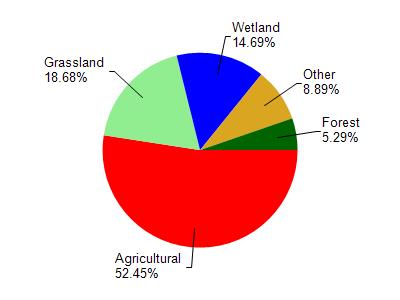
Watershed Characteristics
Sinissippi Lake (Hustisford) is located in the Sinissippi Lake watershed which is 234.93 mi². Land use in the watershed is primarily agricultural (52.50%), grassland (18.70%) and a mix of wetland (14.70%) and other uses (14.20%). This watershed has 458.18 stream miles, 1,917.70 lake acres and 22,222.24 wetland acres.
Nonpoint Source Characteristics
This watershed is ranked High for runoff impacts on streams, High for runoff impacts on lakes and High for runoff impacts on groundwater and therefore has an overall rank of High. This value can be used in ranking the watershed or individual waterbodies for grant funding under state and county programs.However, all waters are affected by diffuse pollutant sources regardless of initial water quality. Applications for specific runoff projects under state or county grant programs may be pursued. For more information, go to surface water program grants.