General Condition
Broad Street Beach, Lake Superior was evaluated for bacteria in the 2022 cycle: E. coli levels were below listing thresholds, as outlined in 2022 WisCALM. This beach is on the Healthy Waters List.
Date 2022
Author Ashley Beranek
General Condition
Wisconsin Point Beaches 4 and 5 on Lake Superior were evaluated for bacteria in the 2022 cycle: E. coli levels were below listing thresholds, as outlined in 2022 WisCALM. These beaches are on the Healthy Waters List.
Date 2022
Author Ashley Beranek
General Condition
Washington Avenue Beach, Lake Superior was evaluated for bacteria in the 2022 cycle: E. coli levels were below listing thresholds, as outlined in 2022 WisCALM. This beach is on the Healthy Waters List.
Date 2022
Author Ashley Beranek
General Condition
Thompson West End Park Beach, Lake Superior was evaluated for bacteria in the 2022 cycle: E. coli levels were below listing thresholds, as outlined in 2022 WisCALM. This beach is on the Healthy Waters List.
Date 2022
Author Ashley Beranek
General Condition
Siskiwit Bay Beach East (Cornie Beach) and Siskiwit Bay Beach West (Cornie by Marina Beach) on Lake Superior were evaluated for bacteria in the 2022 cycle: E. coli levels were below listing thresholds, as outlined in 2022 WisCALM. These beaches are on the Healthy Waters List.
Date 2022
Author Ashley Beranek
General Condition
Lake Superior Sioux River Beach North and Sioux River Beach South were evaluated for bacteria in the 2022 cycle: E. coli levels were below listing thresholds, as outlined in 2022 WisCALM. These beaches are on the Healthy Waters List.
Date 2022
Author Ashley Beranek
General Condition
Saxon Harbor Beaches East and West, Lake Superior were evaluated for bacteria in the 2022 cycle: E. coli levels were below listing thresholds, as outlined in 2022 WisCALM. These beaches are on the Healthy Waters List.
Date 2022
Author Ashley Beranek
General Condition
Port Wing Beach East, Lake Superior was evaluated for bacteria in the 2022 cycle: E. coli levels were below listing thresholds, as outlined in 2022 WisCALM. This beach is on the Healthy Waters List.
Date 2022
Author Ashley Beranek
General Condition
Lake Superior Big Bay State Park Beach was assessed for the 2018 listing cycle; E. coli data sample data were clearly below the 2018 WisCALM listing thresholds for the Recreation use. This beach was meeting this designated use and was not considered impaired.
Date 2017
Author Ashley Beranek
General Condition
Lake Superior Little Sand Bay Beach was assessed for the 2018 listing cycle; E. coli data sample data were clearly below the 2018 WisCALM listing thresholds for the Recreation use. This beach was meeting this designated use and was not considered impaired.
Date 2017
Author Ashley Beranek
General Condition
Lake Superior Oronto Bay Beaches were assessed for the 2018 listing cycle; E. coli data sample data were clearly below the 2018 WisCALM listing thresholds for the Recreation use. These beaches were meeting their designated use and were not considered impaired.
Date 2017
Author Ashley Beranek
General Condition
Lake Superior La Pointe Memorial Beach was assessed for the 2018 listing cycle; E. coli data sample data were clearly below the 2018 WisCALM listing thresholds for the Recreation use. This beach was meeting this designated use and was not considered impaired.
Date 2017
Author Ashley Beranek
General Condition
Lake Superior Casper Road Beach was assessed for the 2018 listing cycle; E. coli data sample data were clearly below the 2018 WisCALM listing thresholds for the Recreation use. This beach was meeting this designated use and was not considered impaired.
Date 2017
Author Ashley Beranek
General Condition
Lake Superior 6th Ave W Beach was assessed for the 2018 listing cycle; E. coli data sample data were clearly below the 2018 WisCALM listing thresholds for the Recreation use. This beach was meeting its designated use and not considered impaired.
Date 2017
Author Ashley Beranek
Impaired Waters
Lake Superior was placed under a special fish consumption advisory for PFOS in 2020; this shoreline had a listing of PFOS in fish tissue placed on the 2022 Impaired Waters List.
Date 2022
Author Ashley Beranek
Impaired Waters
Sixth Avenue West Beach, Lake Superior was evaluated for bacteria in the 2022 cycle; E. coli levels were above listing thresholds as outlined in 2022 WisCALM. This beach was added to the 2022 Impaired Waters List.
Date 2022
Author Ashley Beranek
Impaired Waters
Port Wing Beach West, Lake Superior was evaluated for bacteria in the 2022 cycle; E. coli levels were above listing thresholds as outlined in 2022 WisCALM. This beach was added to the 2022 Impaired Waters List.
Date 2022
Author Ashley Beranek
Impaired Waters
Wisconsin Point Lot 12 Beach, Lake Superior was evaluated for bacteria in the 2022 cycle; E. coli levels were above listing thresholds as outlined in 2022 WisCALM. This beach was added to the 2022 Impaired Waters List.
Date 2022
Author Ashley Beranek
Impaired Waters
Kreher Park Beach, Lake Superior was evaluated for bacteria in the 2022 cycle; E. coli levels were above listing thresholds as outlined in 2022 WisCALM. This beach was added to the 2022 Impaired Waters List.
Date 2022
Author Ashley Beranek
Impaired Waters
Herbster Beach, Lake Superior was evaluated for bacteria in the 2022 cycle; E. coli levels were above listing thresholds as outlined in 2022 WisCALM. This beach was added to the 2022 Impaired Waters List.
Date 2022
Author Ashley Beranek
Impaired Waters
Bayview Park Beach, Lake Superior was evaluated for bacteria in the 2022 cycle; E. coli levels were above listing thresholds as outlined in 2022 WisCALM. This beach was added to the 2022 Impaired Waters List.
Date 2022
Author Ashley Beranek
Impaired Waters
Lake Superior Amnicon River Beach was assessed for the 2018 listing cycle; E. coli data sample data were clearly below the 2018 WisCALM listing thresholds for the Recreation use. However, even though this beach was not considered impaired according to assessment, it will not be delisted because of the lack of no new data. This beach remains listed because of the number of beach closures in 2016.
Date 2017
Author Amanda Smith
Impaired Waters
Lake Superior Wisconsin Point Beach 1 and 3 were assessed for the 2018 listing cycle; E. coli data sample data were clearly below the 2018 WisCALM listing thresholds for the Recreation use. However, this beach was not delisted based on biologist comments. This beach was not meeting this designated use and was considered impaired.
Date 2017
Author Amanda Smith
Impaired Waters
Lake Superior Middle River Beach was assessed for the 2018 listing cycle; E. coli data sample data were clearly below the 2018 WisCALM listing thresholds for the Recreation use. However, this beach was not delisted due to the lack of new data. This beach was not meeting this designated use and was considered impaired due to the number of beach closures in 2016.
Date 2017
Author Amanda Smith
Impaired Waters
Lake Superior Brule River State Forest Beach #3 was assessed for the 2018 listing cycle; E. coli data sample data exceeded the 2018 WisCALM listing thresholds for the Recreation use. This beach was not meeting this designated use and was considered impaired.
Date 2017
Author Amanda Smith
Impaired Waters
Barker Island Inner Beach was assessed during the 2018 listing cycle; new E. coli sample data clearly exceeded the 2018 WisCALM listing thresholds for the Recreation use. This beach was proposed for E. coli listing again in 2018.
Date 2017
Author Ashley Beranek
Impaired Waters
Lake Superior Maslowski Beach was placed on the impaired waters list for Recreational Restrictions due to E. coli in 2016. The 2018 assessments showed continued Recreational Restrictions due to E. coli; new E. coli sample data clearly exceeded the 2018 WisCALM listing thresholds for the Recreation use. Based on the most updated information, no change in the existing impaired waters listing was needed.
Date 2017
Author Ashley Beranek
Impaired Waters
Lake Superior Wisconsin Point Beach #2 was placed on the impaired waters list for Recreational Restrictions due to E. coli in 2008. The 2018 assessments showed continued Recreational Restrictions due to E. coli; new E. coli sample data clearly exceeded the 2018 WisCALM listing thresholds for the Recreation use. Based on the most updated information, no change in the existing impaired waters listing was needed.
Date 2017
Author Ashley Beranek
Condition
Wisconsin has over 84,000 miles of streams, 15,000 lakes and milllions of acres of wetlands. Assessing the condition of this vast amount of water is challenging. The state's water monitoring program uses a media-based, cross-program approach to analyze water condition. An updated monitoring strategy (2015-2020) is now available. Compliance with Clean Water Act fishable, swimmable standards are located in the Executive Summary of Water Condition in 2018. See also the 'monitoring and projects' tab.
Reports
Recommendations
Aquatic Plant Monitoring or Survey
Miller Dam Lake (Chequamegon Waters Flowage) Association will conduct an Aquatic Plant Survey
Aquatic Invasives Research
This project will prioritize management actions based on threats posed to culturally significant resources by invasive plants. GLIFWC has documented over 8,000 non-native invasive plant sites in the Lake Superior counties of Wisconsin and Michigan. This data is being used to develop species distribution models for invasive plants. GLIFWC will develop similar models for culturally significant native species. Comparing these models will identify which invasives pose the greatest risk, and help prioritize areas for early detection/rapid response efforts.
Project Deliverable
This project will provide the following deliverables for the entire south shore of Lake Superior in Wisconsin and the Upper Peninsula of Michigan: 1) electronic device, toxic waste material, and petroleum based oil collection; 2) creation of a GIS data layer that identifies the locations of business and industry that contain hazardous materials in their MSDS and/or waste stream; and, 3) create/disseminate information to the public regarding the effect toxins have on the Lake Superior watershed - particularly the toxins contained in electronic devices.
Aquatic Plant Monitoring or Survey
Area infested by invasive species
Baseline: 4100 feet
Value at Grant Completion: 0 feet
Long-term Value: enhances recovery of native plant community
Year Long-term Value will be Achieved: 2011
Monitor Fish Tissue
GLIFWC will determine mercury levels in walleye, lake trout, whitefish, cisco, and siscowet from Lake Superior and walleye from inland lakes. Test results for selected fish species and areas in Lake Superior will be compared with data from previous testing. Results from inland waters will be used to update tribal and lake specific GIS maps and consumption advice aimed at reducing health risks associated with consuming mercury contaminated walleye.
Habitat Restoration - Upland
Native vegetation cover
Baseline: <50%
Value at Grant Completion: >90%
Long-term Value: restores native plant communty
Year Long-term Value will be Achieved: 2011
Monitor Targeted Area
The Chequamegon Bay Area Partnership requests funding to provide beach sanitary surveys on eight previously un-surveyed beaches on tribal lands and implement actions to target, reduce, and remove the contamination identified in the watershed.
Restore Riparian Habitat
The Chequamegon Bay Area Partnership (CBAP), a collaboration of educational staff, tribal agencies, local citizens, natural resource agencies, and local governments, through lead applicant, Northland College, will restore and protect fish and other aquatic organism habitat in tributaries of the Chequamegon Bay watershed of Lake Superior. Projects reduce erosion and sedimentation through proper design and replacement of degraded culverts and will restore connectivity of tributaries to the lake by removing structural impediments to fish and other aquatic organisms. This proposal incorporates planning, design, implementation, and monitoring of fish and aquatic organism passage.
Monitoring Ecosystem
Under this project and with assistance from WDNR, Lake Superior Research Institute (LSRI) will conduct a comprehensive ecological assessment of Wisconsins Lake Superior basin communities identified as priority areas by the WDNR Plan. Sites and parameters proposed in this project were selected using guidance from the Wisconsin Great Lakes Strategy, the Lake Superior Binational Work Group 2011 Monitoring Priorities, and discussions with WDNR Lake Superior fisheries biologists and resource managers and are identified in the WDNR Plan. Sites included in the project are not part of the National Coastal Condition Assessment.
Recreational Use Survey
The Great Lakes are the recreational outlet for millions of individuals and the need to close beaches should be kept to a minimum. The Great Lakes Regional Collaboration has as a goal the 90 95% reduction in chemical, algal, and bacterial contamination through the identification of nonpoint source pollution, implicated as a major source of contamination to the recreational waters of WI. Pollution of the nearshore waters of Lake Michigan and Lake Superior not only poses a threat to public health, but also to the economic wellbeing and quality of life for WI residents. Pollution of nearshore water quality also has ramifications for ecosystem health.
Restore Riparian Habitat
Shoreline feet restored/enhanced
Baseline: 0 feet
Value at Grant Completion: 4100 feet
Long-term Value: restores natural plant and wildlife community
Year Long-term Value will be Achieved: 2011
Information and Education
The Forum proposes to complete five outreach activities that promote the goals of the Lakewide Management Plan (LaMP) and the Great Lakes Regional Collaboration (GLRC). These activities target multiple primary audiences: public stakeholders; local elected officials; the faith community; recreational kayakers/canoeists; marina owners and users; and several secondary audiences. All audiences are positively affected by these outreach activities as we inform lake stakeholders how to reduce negative impacts on their communities and promote sustainable lifestyle choices, thus improving the overall quality of life in the basin. These projects include the following: 1. Launch a Lake Superior Stewards Project to Build Watershed Capacity 2. Develop a Bernie the Burn Barrel Display 3. Promote Climate Change Outreach to Watersheds through Webinars and Collaborations 4. Expand Education/Outreach about LaMP Priorities: Outreach at Special Events 5. Hold Special Meetings with Local Elected Officials to Build Watershed Capacity
TMDL Implementation
St. Louis River system exceeds water quality criteria, including wildlife and human threshold and human cancer. Fish tissue confirms fish consumption advisories for the river.
TMDL Development
St. Louis River system exceeds water quality criteria, including wildlife and human threshold and human cancer. Fish tissue confirms fish consumption advisories for the river.
Monitor AOC Beneficial Use Impairments
Hog Island. This project involves evaluating 303d waters including Newton Creek and Hog Island Inlet which is required for proposing removal of waters from the state's impaired waters list. To complete necessary monitoring as required by EPA.
Sediment Remediation
Conduct sediment sampling to determine the extent of contamination in Howards Bay and continue actions to advance remediation of contaminated sediment in the Bay.
Restore Riparian Habitat
Habitat Restoration - Instream
Conduct mulitple restorations in Wisconsin's Lake Superior Basin annually. Up to 100% funding of restoration costs. A 10 year voluntary agreement is required.
Management Goals
Wisconsin's Water Quality Standards provide qualitative and quantitative goals for waters that are protective of Fishable, Swimmable conditions [Learn more]. Waters that do not meet water quality standards are considered impaired and restoration actions are planned and carried out until the water is once again fishable and swimmable
Management goals can include creation or implementation of a Total Maximum Daily Load analysis, a Nine Key Element Plan, or other restoration work, education and outreach and more. If specific recommendations exist for this water, they will be displayed below online.
Watershed Characteristics
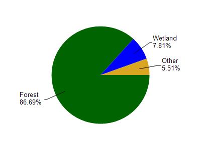
Lake Superior is located in the Bayfield Peninsula Northwest watershed which is 236.05 mi². Land use in the watershed is primarily forest (86.60%), wetland (7.80%) and a mix of grassland (4.60%) and other uses (0.90%). This watershed has 473.06 stream miles, 43,216.55 lake acres and 6,677.27 wetland acres.
Nonpoint Source Characteristics
This watershed is ranked Not Ranked for runoff impacts on streams, Not Available for runoff impacts on lakes and Low for runoff impacts on groundwater and therefore has an overall rank of Low. This value can be used in ranking the watershed or individual waterbodies for grant funding under state and county programs.However, all waters are affected by diffuse pollutant sources regardless of initial water quality. Applications for specific runoff projects under state or county grant programs may be pursued. For more information, go to surface water program grants.