Washington
No
No
No
Fish and Aquatic Life
Overview
The Oconomowoc River begins in southern Washington County and flows southwesterly to the Rock River in Jefferson County. The river flows through a number of larger natural lakes in Waukesha County. The slender madtom, a small catfish on the state's endangered list, has been found in the Oconomowoc River. The statewide population of this fish has been declining over the past 20 years. The slender madtom is highly sensitive to siltation and water quality problems. Its presence indicates that the reach of the Oconomowoc River where it is found may be some of the best warmwater habitat in southern Wisconsin. This high-quality habitat is threatened by the area's rapid suburbanization (Lyons, 1995).
In 1999, the DNR conducted baseline monitoring on the river. The fisheries data collected indicated that the river was in fair condition. Other data showed the river to be in fair to good condition.
Section above Friess Lake
The Oconomowoc River originates in Section 10 of the Richfield Township, receiving flow at its headwaters from several agricultural drainage ditches. The township is experiencing increasing urbanization.The river flows for five miles before entering Friess Lake. The upper half of the river has been straightened, while the lower portion below Pleasant Hill Road retains much of its natural meander. A major drainage channel enters the river from the north in section 8 of Richfield Township. This section of the Oconomowoc River has many adjacent wetlands important for northern pike spawning.
Date 2002
Author Aquatic Biologist
Condition
Wisconsin has over 84,000 miles of streams, 15,000 lakes and milllions of acres of wetlands. Assessing the condition of this vast amount of water is challenging. The state's water monitoring program uses a media-based, cross-program approach to analyze water condition. An updated monitoring strategy (2015-2020) is now available. Compliance with Clean Water Act fishable, swimmable standards are located in the Executive Summary of Water Condition in 2018. See also the 'monitoring and projects' tab.
Reports
Recommendations
Citizen-Based Stream Monitoring
Collect chemical, physical, and/or biological water quality data to assess the current overall stream health. The data can inform management decisions and may be used to identify impaired waters for biennial lists.
Monitor Water Quality or Sediment
More data collect, continuous monitoring, biology not showing impairment AU: 11485; ID: 10029786
Nutrient Budget Development
North Lake Management District is sponsoring project to complete a sediment and nutrient study for the Oconomowoc River Watershed with the following goals: 1) Estimate watershed sediment, phosphorus, and pollutant sources and loads of the River 2) Evaluate sediment accretion/erosion/transport within the Monches Millpond and the River downstream of the Dam 3) Complete in-stream bank and bed survey 4) Examine sediment and riverbed stability within the former Funks Millpond 5) Communicate results and recommendations to the District, WDNR, and other interested parties. Project deliverables: completion of a comprehensive report including the following elements: 1) Historical, present-day, and planned future land use information to help estimate phosphorus, sediment, and select pollutant loads, 2) Mapped changes to sediment deposits created by using digital orthophotography to evaluate changes to sediment bars and general channel form within the Monches Millpond and the River downstream and related to changes during and immediately after dam reconstruction/removal will also be mapped, 3) On-water survey data including: channel form, sediment types and distribution, debris jams and channel obstructions, eroding banks and unstable channel form, riparian vegetation, and potentially other factors. Attention will be given to channel stability in the former Funks impoundment, millrace, and dam area. 4) Discussion of project background issues, conclusions, and recommendations generated will be in a format useful to the WDNR and average Lake user.
Nine Key Element Plan
Oconomowoc River PWS Plan - Nine Key Element Plan - The Oconomowoc River Priority Watershed Project plan assesses the nonpoint sources of pollution in the Oconomowoc River Watershed and guides the implementation of nonpoint source control measures. These control measures are needed to meet specific water resource objectives for the Oconomowoc River and its tributaries. The purpose of this project is to reduce the amount of pollutants originating from nonpoint sources that reach surface water and groundwater within the Oconomowoc River Priority Watershed Project area.
Management Goals
Wisconsin's Water Quality Standards provide qualitative and quantitative goals for waters that are protective of Fishable, Swimmable conditions [Learn more]. Waters that do not meet water quality standards are considered impaired and restoration actions are planned and carried out until the water is once again fishable and swimmable
Management goals can include creation or implementation of a Total Maximum Daily Load analysis, a Nine Key Element Plan, or other restoration work, education and outreach and more. If specific recommendations exist for this water, they will be displayed below online.
Monitoring
Monitoring the condition of a river, stream, or lake includes gathering physical, chemical, biological, and habitat data. Comprehensive studies often gather all these parameters in great detail, while lighter assessment events will involve sampling physical, chemical and biological data such as macroinvertebrates. Aquatic macroinvertebrates and fish communities integrate watershed or catchment condition, providing great insight into overall ecosystem health. Chemical and habitat parameters tell researchers more about human induced problems including contaminated runoff, point source dischargers, or habitat issues that foster or limit the potential of aquatic communities to thrive in a given area. Wisconsin's Water Monitoring Strategy was recenty updated.
Grants and Management Projects
Monitoring Projects
| WBIC | Official Waterbody Name | Station ID | Station Name | Earliest Fieldwork Date | Latest Fieldwork Date | View Station | View Data |
|---|
| 848200 | Oconomowoc River | 10047575 | Oconomowoc River at County Line Rd (HWY Q) North of Monches Millpond 38 | 5/31/2017 | 12/18/2023 | Map | Data |
| 848200 | Oconomowoc River | 10017624 | Oconomowoc River - Loew Lake -- Access | 8/3/2022 | 6/29/2023 | Map | Data |
|
Watershed Characteristics
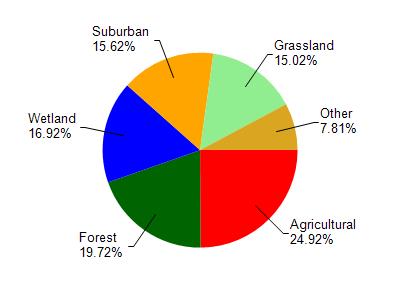
Oconomowoc River is located in the Oconomowoc River watershed which is 130.86 mi². Land use in the watershed is primarily agricultural (24.90%), forest (19.70%) and a mix of wetland (16.90%) and other uses (38.40%). This watershed has 136.99 stream miles, 2,858.66 lake acres and 11,105.19 wetland acres.
Nonpoint Source Characteristics
This watershed is ranked Not Available for runoff impacts on streams, Not Available for runoff impacts on lakes and High for runoff impacts on groundwater and therefore has an overall rank of High. This value can be used in ranking the watershed or individual waterbodies for grant funding under state and county programs.However, all waters are affected by diffuse pollutant sources regardless of initial water quality. Applications for specific runoff projects under state or county grant programs may be pursued. For more information, go to surface water program grants.