Oneida
No
No
Yes
Fish and Aquatic Life
Overview
Kawaguesaga Lake, in the Upper Tomahawk River Watershed, is a 699.76 acre lake that falls in Oneida County. This lake is managed for fishing and swimming and is currently considered impaired.
Date 2016
Author Ashley Beranek
Historical Description
Source: 1966, Surface Water Resources of Oneida County
Kawaguesaga Lake, T39N, R6E, Section 16
Surface Acres = 801, S.D.F. = 2.75, Maximum Depth = 41 feet
A soft water drainage lake having slightly acid clear water of
moderate transparency. Sand (50 percent) and gravel (32 percent)
are the predominant littoral materials with muck (15 percent) and
some rubble present. The shoreline is predominantly upland (90
percent) with bog and marsh wetlands adjoining limited portions of
the lake basin. Muskellunge, northern pike, walleye, largemouth
bass, smallmouth bass, perch, bluegill, crappie, rock bass,
pumpkinseed, bullhead, cisco and sucker inhabit this lake. Public
access without parking as well as access of the navigable water
type from Minocqua Lake are available. Thirteen resorts, 75
dwellings and a boys' camp are located on the lakeshore. Mallard,
black duck and hooded merganser use this lake as a nesting site.
Puddle ducks and diving ducks make use of this lake on their fall
migrations. A water control structure of four head feet is located
on the outlet stream with allowable drawdown of 3 feet 2 inches.
Part of the Minocqua Chain.
Date 1966
Author Surface Water Inventory Of Wisconsin
Management Goals
Wisconsin's Water Quality Standards provide qualitative and quantitative goals for waters that are protective of Fishable, Swimmable conditions [Learn more]. Waters that do not meet water quality standards are considered impaired and restoration actions are planned and carried out until the water is once again fishable and swimmable
Management goals can include creation or implementation of a Total Maximum Daily Load analysis, a Nine Key Element Plan, or other restoration work, education and outreach and more. If specific recommendations exist for this water, they will be displayed below online.
Monitoring
Monitoring the condition of a river, stream, or lake includes gathering physical, chemical, biological, and habitat data. Comprehensive studies often gather all these parameters in great detail, while lighter assessment events will involve sampling physical, chemical and biological data such as macroinvertebrates. Aquatic macroinvertebrates and fish communities integrate watershed or catchment condition, providing great insight into overall ecosystem health. Chemical and habitat parameters tell researchers more about human induced problems including contaminated runoff, point source dischargers, or habitat issues that foster or limit the potential of aquatic communities to thrive in a given area. Wisconsin's Water Monitoring Strategy was recenty updated.
Grants and Management Projects
Monitoring Projects
| WBIC | Official Waterbody Name | Station ID | Station Name | Earliest Fieldwork Date | Latest Fieldwork Date | View Station | View Data |
|---|
| 1542300 | Kawaguesaga Lake | 10055076 | Kawaguesaga Lake - K2 (Q-21 Application Area) | 6/22/2021 | 6/29/2021 | Map | Data |
| 1542300 | Kawaguesaga Lake | 10055091 | Kawaguesaga Lake - K4 (West Bay - QR Bay) | 6/22/2021 | 6/29/2021 | Map | Data |
| 1542300 | Kawaguesaga Lake | 10053841 | Kawaguesaga Lake-Herbicide Monitoring Site K1 | 6/30/2020 | 7/1/2020 | Map | Data |
| 1542300 | Kawaguesaga Lake | 10055077 | Kawaguesaga Lake - K3 (R-21 Application Area) | 6/22/2021 | 6/29/2021 | Map | Data |
| 1542300 | Kawaguesaga Lake | 10055078 | Kawaguesaga Lake - K6 (SW Basin AOPI) | 6/22/2021 | 7/29/2025 | Map | Data |
| 1542300 | Kawaguesaga Lake | 10052703 | Kawaguesaga Lake - Herbicide Site - Dam2 | | | Map | Data |
| 1542300 | Kawaguesaga Lake | 443529 | Kawaguesaga Lake -- Dam Road - Boat Landing | 2/1/2006 | 6/29/2025 | Map | Data |
| 1542300 | Kawaguesaga Lake | 10052704 | Kawaguesaga Lake - Herbicide Site - Dam3 | | | Map | Data |
| 1542300 | Kawaguesaga Lake | 10055079 | Kawaguesaga Lake - K5 (South Bay - P Bay) | 6/22/2021 | 6/29/2021 | Map | Data |
| 1542300 | Kawaguesaga Lake | 10001441 | Kawaguesaga Lake | 8/21/1996 | 9/21/2017 | Map | Data |
| 1542300 | Kawaguesaga Lake | 10053843 | Kawaguesaga Lake-Herbicide Monitoring Site K2 | 6/30/2020 | 7/1/2020 | Map | Data |
| 1542300 | Kawaguesaga Lake | 10053844 | Kawaguesaga Lake-Herbicide Monitoring Site K3 | 6/30/2020 | 7/1/2020 | Map | Data |
| 1542300 | Kawaguesaga Lake | 443129 | Kawaguesaga Lake - Deep Hole | 8/15/1973 | 10/18/2022 | Map | Data |
| 1515800 | Tomahawk River | 443529 | Kawaguesaga Lake -- Dam Road - Boat Landing | 2/1/2006 | 6/29/2025 | Map | Data |
| 1542300 | Kawaguesaga Lake | 10052702 | Kawaguesaga Lake - Herbicide Site - Dam1 | | | Map | Data |
| 1542300 | Kawaguesaga Lake | 10052705 | Kawaguesaga Lake - Herbicide Site - Dam4 | | | Map | Data |
| 1542300 | Kawaguesaga Lake | 10053845 | Kawaguesaga Lake-Herbicide Monitoring Site K4 | 6/30/2020 | 7/1/2020 | Map | Data |
| 1542300 | Kawaguesaga Lake | 10055075 | Kawaguesaga Lake - K1 (P-21 Application Area) | 6/22/2021 | 7/8/2025 | Map | Data |
|
Watershed Characteristics
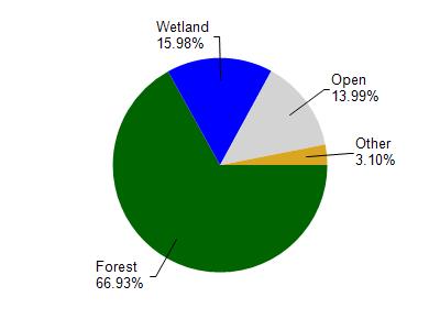
Kawaguesaga Lake is located in the Upper Tomahawk River watershed which is 186.83 mi². Land use in the watershed is primarily forest (67%), wetland (16%) and a mix of open (14%) and other uses (3.10%). This watershed has 139.00 stream miles, 17,609.90 lake acres and 20,470.21 wetland acres.
Nonpoint Source Characteristics
This watershed is ranked High for runoff impacts on streams, High for runoff impacts on lakes and Low for runoff impacts on groundwater and therefore has an overall rank of Low. This value can be used in ranking the watershed or individual waterbodies for grant funding under state and county programs.However, all waters are affected by diffuse pollutant sources regardless of initial water quality. Applications for specific runoff projects under state or county grant programs may be pursued. For more information, go to surface water program grants.