Burnett
No
No
Yes
Fish and Aquatic Life
Overview
Round Lake T37n R18w S27, in the Trade River Watershed, is a 208.34 acre lake that falls in Burnett County. This lake is managed for fishing and swimming and is currently considered impaired.
Date 2011
Author Aquatic Biologist
Historical Description
These four lakes are situated on the Trade River. They have been united under a common
lake association for many years. The Round - Trade Lake Improvement Association (including
Spirit & Long Trade Lakes) has been an active and enthusiastic leader in the pioneering efforts
at lake management in Wisconsin. The four lakes along the Trade River have exhibited signs of
excess fertility for decades. A history of chemical treatment efforts is noted in the files for
Long Trade (Atlas), Round and the Trade Lakes (Big & Little).
The signs of eutrophication are evident on these waters but a definitive nutrient and hydraulic
budget has not been documented. A feasibility study to evaluate the hydraulic and nutrient
loading to the lakes as well as in-lake monitoring to determine recycling and profile
characteristics is a high priority for these lakes. A lakes planning grant or possibly a Clean
Lakes grant study is a possibility.
WRM district staff have been working with this lake group to start the process towards a long
range lake management plan. Self-help volunteers are in place on all four lakes and Round
Lake was one of the original "expanded" monitoring group.
Date 1992
Author Surface Water Inventory Of Wisconsin
Historical Description
Source: 1966, Surface Water Resources of Burnett County Round Lake, T37N, R18W, Sections 27, 34 Surface Acres = 202.8, Maximum Depth = 24 feet, M.P.A. = 69 ppm, Secchi Disk = 2 feet A hard water, drainage lake located on the Trade River. Outlet flow is approximately 14.0 cubic feet per second. The most common fish species are northern pike, walleye, largemouth bass, bluegill, black crappie and carp. Smallmouth bass, perch, rock bass, pumpkinseed, bullhead, white sucker, redhorse and bowfin are also present. Excessive algae growth and carp are management and use problems. The lake has no access and the only public frontage is a 60 foot undeveloped platted access. Private development consists of two resorts and 48 cottages and dwellings. There is a marshy area in the south end of the lake which provides some habitat for muskrats, nesting mallards, blue-winged teal and wood ducks. The lake also receives some use by migrant diving ducks.
Date 1966
Author Surface Water Inventory Of Wisconsin
Impaired Waters
Round Lake (T37n R18w S27, WBIC 2640100) was placed on the impaired waters list in 1998 for Mercury, in 2012 for total phosphorus, and in 2014 for an unknown pollutant in 2014. The 2018 assessments showed continued impairment by phosphorus; total phosphorus and chlorophyll-a sample data exceeded the 2018 WisCALM listing thresholds for the Recreation use and Fish and Aquatic Life use. The Unknown Pollutant is proposed for deletion from the list - its associated impairment of Eutrophication is now associated with the Total Phosphorus pollutant listing.
Date 2017
Author Ashley Beranek
Impaired Waters
Round Lake T37n R18w S27 (2640100) was placed on the impaired waters list in 1998 for Mercury, in 2012 for total phosphorus, and in 2014 for an unknown pollutant in 2014. The 2016 assessments showed continued impairment by phosphorus and unknown pollutant; total phosphorus sample data overwhelmingly exceeded 2016 WisCALM listing thresholds for the Recreation use, but not Fish and Aquatic Life use, and chlorophyll data exceeded both REC and FAL thresholds. Based on the most updated information, no change in existing impaired waters listing is needed.
Date 2015
Author Aaron Larson
Condition
Wisconsin has over 84,000 miles of streams, 15,000 lakes and milllions of acres of wetlands. Assessing the condition of this vast amount of water is challenging. The state's water monitoring program uses a media-based, cross-program approach to analyze water condition. An updated monitoring strategy (2015-2020) is now available. Compliance with Clean Water Act fishable, swimmable standards are located in the Executive Summary of Water Condition in 2018. See also the 'monitoring and projects' tab.
Reports
Recommendations
Watercraft Inspections Clean Boats, Clean Waters
Clean Boats, Clean Waters on Round Lake, Burnett County
Monitor Invasive Species
Monitor Invasive Species on Round Lake, Burnett County
Monitor Fish Tissue
Management Goals
Wisconsin's Water Quality Standards provide qualitative and quantitative goals for waters that are protective of Fishable, Swimmable conditions [Learn more]. Waters that do not meet water quality standards are considered impaired and restoration actions are planned and carried out until the water is once again fishable and swimmable
Management goals can include creation or implementation of a Total Maximum Daily Load analysis, a Nine Key Element Plan, or other restoration work, education and outreach and more. If specific recommendations exist for this water, they will be displayed below online.
Monitoring
Monitoring the condition of a river, stream, or lake includes gathering physical, chemical, biological, and habitat data. Comprehensive studies often gather all these parameters in great detail, while lighter assessment events will involve sampling physical, chemical and biological data such as macroinvertebrates. Aquatic macroinvertebrates and fish communities integrate watershed or catchment condition, providing great insight into overall ecosystem health. Chemical and habitat parameters tell researchers more about human induced problems including contaminated runoff, point source dischargers, or habitat issues that foster or limit the potential of aquatic communities to thrive in a given area. Wisconsin's Water Monitoring Strategy was recenty updated.
Grants and Management Projects
Monitoring Projects
| WBIC | Official Waterbody Name | Station ID | Station Name | Earliest Fieldwork Date | Latest Fieldwork Date | View Station | View Data |
|---|
| 2640100 | Round Lake | 10001043 | Round Lake | 9/5/2000 | 6/29/2025 | Map | Data |
| 2640100 | Round Lake | 10051035 | Round Lake - North Bay | 5/29/2018 | 6/1/2018 | Map | Data |
| 2640100 | Round Lake | 10051037 | Round Lake - South Bay | 5/29/2018 | 6/1/2018 | Map | Data |
| 2640100 | Round Lake | 073039 | Round Lake - Deep Hole | 6/24/1986 | 7/17/2026 | Map | Data |
| 2640100 | Round Lake | 074036 | Round Lake - Round Lake | 8/13/1979 | 8/13/1979 | Map | Data |
| 2640100 | Round Lake | 10051033 | Round Lake - Outlet | 5/29/2018 | 6/1/2018 | Map | Data |
| 2640100 | Round Lake | 135 | Round Lake | 7/8/1976 | 7/8/1976 | Map | Data |
| 2640100 | Round Lake | 10055106 | Round Lake - East Bed | 6/3/2021 | 6/4/2021 | Map | Data |
| 2640100 | Round Lake | 10055105 | Round Lake - West Bed | 6/3/2021 | 6/4/2021 | Map | Data |
| 2640100 | Round Lake | 10018062 | Round Lake -- Access at S End Of Lake At End Of Stillson Rd | 10/21/2003 | 11/17/2025 | Map | Data |
| 2640100 | Round Lake | 10051034 | Round Lake - NE Bay | | | Map | Data |
| 2640100 | Round Lake | 10051036 | Round Lake - SE Bay | 5/29/2018 | 6/1/2018 | Map | Data |
|
Watershed Characteristics
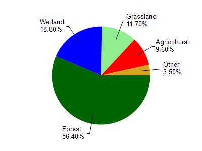
Round Lake is located in the Trade River watershed which is 194.93 mi². Land use in the watershed is primarily forest (56.40%), wetland (18.80%) and a mix of grassland (11.70%) and other uses (13.10%). This watershed has 166.68 stream miles, 2,902.48 lake acres and 21,757.05 wetland acres.
Nonpoint Source Characteristics
This watershed is ranked Medium for runoff impacts on streams, Not Ranked for runoff impacts on lakes and Low for runoff impacts on groundwater and therefore has an overall rank of Low. This value can be used in ranking the watershed or individual waterbodies for grant funding under state and county programs.This water is ranked High Lake for individual Lakes based on runoff problems and the likelihood of success from project implementation.