Jefferson
No
No
Yes
Fish and Aquatic Life
Overview
Rock River Water Quality Management Plan, Lower Rock River Appendix. WT-668-2002. South Central Region, WDNR.
Lake Ripley, a small kettle lake, has good water quality and a very good sport fishery. Much of the lake's shoreline is developed with the village of Cambridge on the west end and summer cottages and year-round homes on the north and south shores. There is a wetland on the east end of the lake that remains undeveloped. Agricultural runoff contributes nutrients and sediments to the lake, and the village of Cambridge and lake cottages and homes also degrade the lake's water quality. Excess nutrients has spurred the growth of Eurasian water milfoil, an aggressive non-native plant, in the lake. a 1989 aquatic plant survey indicates milfoil, which grows in the lake in depths from roughly 2 to 12 feet, has spread to about 50 percent of the lake, concentrating boat traffic in the lake's middle.
Lake Ripley has been the subject of a small-scale priority watershed project since 1994, when its appraisal report was published. The appraisal work indicates that the lake's water quality is on a continued steady decline due to excess phosphorus and sediment inputs. In former years these inputs were almost exclusively from agricultural fields. Residential development of the lake's immediate subwatershed, including 70 percent of its direct shoreline, contributes to high levels of phosphorus and sediment, has lowered aquatic species diversity, and threatens the survival of the Blanding's turtle, an endangered species in Wisconsin.
In 1993 the lake experienced its first reported blue-green algae bloom. High precipitation levels that year and ensuing years have contributed to the influx of pollutants, reflecting the primary source of nutrients--watershed contributions. Lake Ripley is dimictic, meaning it stratifies twice yearly, becoming anoxic in its hypolimnion during winter and summer. This condition likely contributes phosphorus from in-lake sediment during spring and fall mixing; WDNR researchers are involved in estimating in-lake sediment contributions to overall phosphorus loading rates. The lake's priority watershed plan should guide management efforts into the future.
Date 2002
Author Aquatic Biologist
Historical Description
Source: 1968, Surface Water Resources of Jefferson County (Lake) Ripley, T6N, R13E, Section 7, 8
A small, deep, compound kettle lake in the end moraine at Cambridge. The lake drains to Koshkonong Creek, over a low-head rubble sill at the outlet. The water is clear and very hard, over a bottom primarily composed of sand and gravel. A good fishery exists for northern pike, walleye, yellow perch, largemouth bass, bluegills and black crappies. Access is provided by several road ends, generally unimproved. A village park on the south shore provides multiple use access. Boat liveries and a scout provide multiple use access. About 130 acres of marshland provide for mallard and blue-winged teal nesting and northern pike spawning.
Surface Acres = 433.0, S.D.F. = 1.40, Maximum Depth = 50 feet
Date 1968
Author Surface Water Inventory Of Wisconsin
Recommendations
Best Management Practices, Implement
Partnering with property owners, the applicant is sponsoring a grant to implement water quality and habitat best practices from Wisconsin's Healthy Lakes Implementation Plan.
Informational Meetings
Share information at WI Lakes Convention
Issue News/Media Release
Develop/Distribute Newsletter
Diagnostic/Feasibility Assessment
assessment of restoring several native, non-game fish species to lake
Informational Meetings
Monitor Fish Community
Lake Management Plan Development
Protect Riparian or Shorelands
Lake Ripley Management District proposes to undertake a shoreline stabilization and restoration project at the Hoard-Curtis Scout Camp shoreline on Lake Ripley, Jefferson County. They will install riprap off-shore of the existing shoreline (DNR permit already issued), plant aquatic plants inland of that riprap, and do upland seeding (to supplement previously completed plug plantings) after invasive weed and brush removal.
Map Depth of Lake (Bathymetry)
The Lake Ripley Management District will purchase a 65.926-acre parcel of the James & Jane Johnson property in the Town of Oakland, Jefferson County. The property will link the 100-acre Lake Ripley Preserve to 40 acres of DNR-owned wetlands along Lake Ripley's only inlet. This purchase would also ensure the protection, in perpetuity, of a critical stream corridor and wetland/floodplain complex within the headwaters region of Lake Ripley.
Lake Classification
Jefferson County Land and Water Conservation Department will undertake a lake classification process. The resulting lake classification system will enable the County and other lake management entities to implement appropriate lake management strategies in a priority -driven and efficient manner. It will result in the protection and restoration of the water quality and natural ecosystems of the lakes in Jefferson County.
Land Acquisition
Lake Ripley Management District will acquire about 99 acres of croplands and wetlands that help make up the only inlet to Lake Ripley. The acquisition project consists of two parts; 1) about 63 1/2 acres of farmed/wetland and 2) about 35 1/2 acres of drained wetland.
Nine Key Element Plan
Lake Ripley PWS Plan - Nine Key Element Plan - The Lake Ripley Priority Lake Project plan assesses the nonpoint sources of pollution in the Lake Ripley Watershed and guides the implementation of nonpoint source control measures. These control measures are needed to meet specific water resource objectives for Lake Ripley and its tributary. The primary objective of the project is to reduce nonpoint source pollution to the lake.
Management Goals
Wisconsin's Water Quality Standards provide qualitative and quantitative goals for waters that are protective of Fishable, Swimmable conditions [Learn more]. Waters that do not meet water quality standards are considered impaired and restoration actions are planned and carried out until the water is once again fishable and swimmable
Management goals can include creation or implementation of a Total Maximum Daily Load analysis, a Nine Key Element Plan, or other restoration work, education and outreach and more. If specific recommendations exist for this water, they will be displayed below online.
Watershed Characteristics
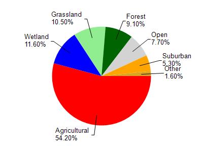
Lake Ripley is located in the Lower Koshkonong Creek watershed which is 265.61 mi². Land use in the watershed is primarily agricultural (54.20%), wetland (11.60%) and a mix of grassland (10.50%) and other uses (23.70%). This watershed has 283.47 stream miles, 1,735.65 lake acres and 18,171.94 wetland acres.
Nonpoint Source Characteristics
This watershed is ranked High for runoff impacts on streams, Medium for runoff impacts on lakes and High for runoff impacts on groundwater and therefore has an overall rank of High. This value can be used in ranking the watershed or individual waterbodies for grant funding under state and county programs.This water is ranked High Lake for individual InlandBeachs based on runoff problems and the likelihood of success from project implementation.