Price
No
No
Yes
Fish and Aquatic Life
Overview
The Flambeau River is a tributary of the Chippewa River in northern Wisconsin. It drains an area of 1,860 square miles (4,800 km2) and descends from an elevation of approximately 1,570 feet (480 m) to 1,060 feet (320 m) above sea level. The Flambeau is an important recreational destination in the region. It is notable among canoeists in the Midwestern USA for outstanding canoe camping, including excellent scenery, fishing and whitewater. The river and its forks have a variety of possible trip lengths from short day outings, to overnight camping, to voyages of a week or more.
The Flambeau River rises in two major forks -- the North Fork and the South Fork. Both originate in north-central Wisconsin and flow generally southwest to their confluence, then continue as the main Flambeau, also southwesterly, to the mouth in the Chippewa River near Bruce, Wisconsin. The North Fork is formed by the confluence of the Manitowish and Bear Rivers just above Turtle-Flambeau Flowage (reservoir). The South Fork's source is Round Lake in northeastern Price County, Wisconsin. Major tributaries include the Turtle River, flowing into the North Fork in the Turtle-Flambeau Flowage, and the Elk River, which flows into the South Fork.
The communities of Park Falls (pop. 2,800) and Oxbo are located along the North Fork. Fifield and Lugerville border the South Fork. Ladysmith, Wisconsin (pop. 3,525) is the only town on the main Flambeau. Generally the river flows through remote areas dominated by second-growth forest, with few road crossings or approaches.
While the South Fork is free-flowing below a small dam at the outlet of Round Lake, the North and Main rivers have several dams that impound small reservoirs, known locally as flowages. Below the dam impounding the Turtle-Flambeau Flowage, the North Fork has three dams between Park Falls and Oxbo. On the main Flambeau below the Forks, there are two, at Big Falls and Ladysmith (Dairyland Reservoir).
The Flambeau river is best known as a classic canoeing stream. Both forks are canoeable from their sources, but most trips start at or downstream of access points near Oxbo on the North Fork or Lugerville on the South Fork, and end upstream of the Big Falls Flowage on the Main. For much of the length of these sections of river, the Flambeau and its forks flow through the Flambeau River State Forest.
The North Fork in this section is rated class I to II on the International Scale of River Difficulty at normal water conditions. Major named rapids are Wannigan and Flambeau Falls. The South Fork is a more difficult whitewater river, with runnable rapids up to class III and a portage at Little Falls. Major named rapids include Stonewall, Big Bull, Slough Gundy, and Scratch. Below the confluence (the Forks), the Main Flambeau is class II down to the Big Falls Flowage. The notable rapids on the Main Flambeau are Cedar and Beaver Dam.
The Flambeau system is considered an important fish habitat and fishing resource, primarily for smallmouth bass and muskellunge (muskie).
Source: http://en.wikipedia.org/wiki/Flambeau_River
Date 2011
Author Aquatic Biologist
Historical Description
Park Falls Area - North Fork Flambeau River (UC13) - Contaminated sediment associated with historic wastewater discharges is a concern in this stretch of the river. Historic paper mill effluent and municipal wastewater discharges are suspected contributors to mercury contamination of sediment in flowages downstream from the outfalls.
About 18 river miles downstream of the Turtle-Flambeau Flowage, four contiguous hydropower projects are in operation. From upstream to downstream the projects are Upper Hydro, Lower Hydro, Pixley Hydro, and Crowley Hydro and cover about 18-20 river miles. All four projects may undergo relicensing in 1996 by the Federal Energy Regulatory Commission. The four flowages formed by the dams are operated as "run-of-river," which means they are maintained within a narrow range and water is discharged at the same rate as it enters the impoundment. Below the Crowley Flowage, the river is a popular canoe route. In the Flambeau River State Forest, the Flambeau River shoreline is protected by a one-quarter mile buffer strip along both sides of the river. Sulfite storage lagoons exist along the shoreline of the Flambeau River just upstream of Park Falls (upstream of Pixley Flowage). Beneath the lagoons contaminated groundwater discharges to the river. This contaminant discharge has resulted in water quality impairments, habitat damage, destruction of shoreline vegetation, odors, and degraded aesthetic values.
Larson, Nancy and Lisa Kosmond (Helmuth). 1996. Upper Chippewa River Basin Water Quality Management Plan. PUBL-WR-345-96-REV. Wisconsin Department of Natural Resources, Madison, WI.
Date 1996
Author Aquatic Biologist
Recommendations
Monitor Water Quality or Sediment
Conduct water quality monitoring on watershed streams including Turtle and Flambeau Rivers and Pardee, Viran, Lone Lake, Weber, Dollar and Beaver Creeks.
Management Goals
Wisconsin's Water Quality Standards provide qualitative and quantitative goals for waters that are protective of Fishable, Swimmable conditions [Learn more]. Waters that do not meet water quality standards are considered impaired and restoration actions are planned and carried out until the water is once again fishable and swimmable
Management goals can include creation or implementation of a Total Maximum Daily Load analysis, a Nine Key Element Plan, or other restoration work, education and outreach and more. If specific recommendations exist for this water, they will be displayed below online.
Monitoring
Monitoring the condition of a river, stream, or lake includes gathering physical, chemical, biological, and habitat data. Comprehensive studies often gather all these parameters in great detail, while lighter assessment events will involve sampling physical, chemical and biological data such as macroinvertebrates. Aquatic macroinvertebrates and fish communities integrate watershed or catchment condition, providing great insight into overall ecosystem health. Chemical and habitat parameters tell researchers more about human induced problems including contaminated runoff, point source dischargers, or habitat issues that foster or limit the potential of aquatic communities to thrive in a given area. Wisconsin's Water Monitoring Strategy was recenty updated.
Grants and Management Projects
Monitoring Projects
| WBIC | Official Waterbody Name | Station ID | Station Name | Earliest Fieldwork Date | Latest Fieldwork Date | View Station | View Data |
|---|
| 2225000 | Flambeau River | 513008 | Flambeau River - Clrg Nr Liquor Ponds | 6/28/1975 | 8/7/1980 | Map | Data |
| 2225000 | Flambeau River | 513006 | Lower Park Falls Flowage - Headwater above lower dam | 2/21/1975 | 8/12/2020 | Map | Data |
| 2225000 | Flambeau River | 513007 | Flambeau River - Lower Dam Tailrace | 2/28/1989 | 11/29/2010 | Map | Data |
| 2225000 | Flambeau River | 513010 | Flambeau River at Cth B | 2/21/1975 | 11/10/2008 | Map | Data |
| 2225000 | Flambeau River | 10020408 | Flambeau River -- Demars Bridge Carry-In | | | Map | Data |
|
Watershed Characteristics
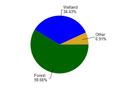
Flambeau River is located in the Upper North Fork Flambeau River watershed which is 158.21 mi². Land use in the watershed is primarily forest (58.60%), wetland (34.40%) and a mix of grassland (2.90%) and other uses (4.00%). This watershed has 163.80 stream miles, 629.65 lake acres and 33,475.50 wetland acres.
Nonpoint Source Characteristics
This watershed is ranked Low for runoff impacts on streams, Low for runoff impacts on lakes and Low for runoff impacts on groundwater and therefore has an overall rank of Low. This value can be used in ranking the watershed or individual waterbodies for grant funding under state and county programs.However, all waters are affected by diffuse pollutant sources regardless of initial water quality. Applications for specific runoff projects under state or county grant programs may be pursued. For more information, go to surface water program grants.