Douglas
No
Yes
No
Fish and Aquatic Life
Overview
Upper St. Croix Lake, in the Upper St. Croix and Eau Claire Rivers Watershed, is a 828.27 acre lake that falls in Douglas County. This lake is an outstanding/exceptional resource water under NR102 under the Fisheries Program. This lake is managed for fishing and swimming and is currently not considered impaired.
Date 2011
Author Aquatic Biologist
Historical Description
This lake is situated at the headwaters of the St. Croix River. In addition to its status as a
major contemporary recreational resource this waterbody occupies a place in history as a part of
the Brule - St. Croix portage. The early European explorers often stopped on this lake in their
journeys from Lake Superior to the Mississippi River.
Upper St. Croix Lake has been nominated as an "Outstanding Resource Water" and has an
excellent fishery as well as providing significant aquatic recreational opportunities. This lake
does exhibit some symptoms of eutrophication that are somewhat unexpected from a waterbody
located at the headwaters of a stream system. The Village of Solon Springs is situated on the
west shore of this lake and did experience some problems with groundwater pollution from
individual sewage disposal systems in the past. This problem has been corrected with the
installation of a municipal collection and treatment system.
A feasibility study to assess the current status of water quality in this lake and the nutrient
budget would be a desireable first step for this lake community. A long range lake management
plan would be the logical goal for this important lake.
This ORW nominated lake should be considered as a high priority for a Priority Lakes project.
Date 1992
Author Surface Water Inventory Of Wisconsin
General Condition
Upper St. Croix Lake (2747300) was assessed during the 2016 listing cycle; total phosphorus sample data were clearly below 2016 WisCALM listing thresholds for Recreation use and Fish and Aquatic Life use. Chlorophyll sample data were clearly below FAL use listing thresholds and did not exceed REC listing thresholds. This water was also assessed for chlorides and sample data were clearly below 2016 WisCALM chronic and acute listing criteria for the Fish and Aquatic Life use. This water is meeting these designated uses and is not considered impaired.
Date 2015
Author Ashley Beranek
Condition
Wisconsin has over 84,000 miles of streams, 15,000 lakes and milllions of acres of wetlands. Assessing the condition of this vast amount of water is challenging. The state's water monitoring program uses a media-based, cross-program approach to analyze water condition. An updated monitoring strategy (2015-2020) is now available. Compliance with Clean Water Act fishable, swimmable standards are located in the Executive Summary of Water Condition in 2018. See also the 'monitoring and projects' tab.
Reports
Recommendations
Control Invasive Species
2747300
Upper Saint Croix Lake
Watercraft Inspections Clean Boats, Clean Waters
2747300
Upper Saint Croix Lake
Nine Key Element Plan
Upper St. Croix - Eau Clair Rivers PWS Plan - Nine Key Element Plan - The Upper St. Croix - Eau Clair Rivers Priority Watershed is at the headwaters of the St. Croix River and the Mississippi River system. The historical significance of this resource is well documented in many accounts referring to the beauty and abundance of this outstanding resource. In 1988, the St. Croix River was designated as an Outstanding Resource Water by the State of Wisconsin. The Upper St. Croix - Eau Clair Rivers watershed project has a protection orientation, as opposed to the more traditional remediation based watershed projects, and takes a proactive approach to prevent nonpoint pollution before it happens.
Management Goals
Wisconsin's Water Quality Standards provide qualitative and quantitative goals for waters that are protective of Fishable, Swimmable conditions [Learn more]. Waters that do not meet water quality standards are considered impaired and restoration actions are planned and carried out until the water is once again fishable and swimmable
Management goals can include creation or implementation of a Total Maximum Daily Load analysis, a Nine Key Element Plan, or other restoration work, education and outreach and more. If specific recommendations exist for this water, they will be displayed below online.
Monitoring
Monitoring the condition of a river, stream, or lake includes gathering physical, chemical, biological, and habitat data. Comprehensive studies often gather all these parameters in great detail, while lighter assessment events will involve sampling physical, chemical and biological data such as macroinvertebrates. Aquatic macroinvertebrates and fish communities integrate watershed or catchment condition, providing great insight into overall ecosystem health. Chemical and habitat parameters tell researchers more about human induced problems including contaminated runoff, point source dischargers, or habitat issues that foster or limit the potential of aquatic communities to thrive in a given area. Wisconsin's Water Monitoring Strategy was recenty updated.
Grants and Management Projects
| Project Name (Click for Details) | Year Started |
|---|
| Clean Boats, Clean Waters - Upper St. Croix Lake | 2007 |
| Upper St. Croix - Eau Clair Rivers PWS Plan - Nine Key Element Plan | 1997 |
| UPPER ST CROIX LAKE ASSOCIATION: Upper St Croix Lake Association 2021 CBCW | 2021 |
| UPPER ST CROIX LAKE ASSOCIATION: Upper St. Croix Lake Protection Grant App/Proposal | 2010 |
| UPPER ST CROIX LAKE ASSOCIATION: AIS Education, Prevention & Monitoring on Upper St. Croix Lk & St. Croix River Headwaters | 2011 |
| UPPER ST CROIX LAKE ASSOCIATION: Community Approach to Lake Planning,etc.-#4 | 2007 |
| UPPER ST CROIX LAKE ASSOCIATION: Community Approach to Lake Planning, etc.-#3 | 2007 |
| UPPER ST CROIX LAKE ASSOCIATION: AIS Education, Prevention & Monitoring on Upper St. Croix Lk & Headwaters of St. Croix River | 2010 |
| UPPER ST CROIX LAKE ASSOCIATION: Upper St Croix Lk 2016 CBCW Project | 2016 |
| UNIVERSITY OF WISCONSIN-SUPERIOR: Upper St. Croix Lk Yellow Iris Early Detection/Response 2013-2015 | 2013 |
| UPPER ST CROIX LAKE ASSOCIATION: Upper St. Croix Lake Association 2020 CBCW | 2020 |
| DOUGLAS COUNTY LWCD: Implementing Douglas Co. Aquatic Invasive Species Program | 2012 |
| FRIENDS OF THE ST CROIX HEADWATERS, INC.: Pilot Aquatic Macrophyte River & Lake Surveys in the Upper St. Croix Watershed | 2009 |
| UPPER ST CROIX LAKE ASSOCIATION: AIS Education, Prevention & Monitoring on Upper St. Croix Lake & Headwaters of St. Croix River | 2010 |
| UPPER ST CROIX LAKE ASSOCIATION: A Community Management Approach: Grant 5 | 2007 |
| UPPER ST CROIX LAKE ASSOCIATION: Upper St Croix Lake Association 2023 CBCW | 2023 |
| UPPER ST CROIX LAKE ASSOCIATION: AIS Education, Prevention & Monitoring Project | 2013 |
| VILLAGE OF SOLON SPRINGS: AIS Control for Evasion of Watermilfoil | 2007 |
| UPPER ST CROIX LAKE ASSOCIATION: AIS Control & CBCW Project | 2015 |
| UPPER ST CROIX LAKE ASSOCIATION: Upper St Croix Lake Association 2019 CBCW | 2019 |
| UPPER ST CROIX LAKE ASSOCIATION: A Community Approach to Data Collection, Lake Modeling & Strategic Planning, Phase 1 | 2006 |
| UPPER ST CROIX LAKE ASSOCIATION: A Community Approach to Data Collection, Lake Modeling, & Strategic Planning, Phase 2 | 2006 |
| UPPER ST CROIX LAKE ASSOCIATION: Eurasian Watermilfoil Monitoring on Upper St. Croix & Headwaters | 2008 |
| UPPER ST CROIX LAKE ASSOCIATION: Upper St Croix Lake Association 2018 CBCW | 2018 |
| UPPER ST CROIX LAKE ASSOCIATION: Upper St Croix Lake Association 2022 CBCW | 2022 |
| Fish Propagation Actions | 2001 |
| UPPER ST CROIX LAKE ASSOCIATION: AIS Education, Prevention & Monitoring on Up. St. Croix Lk & River Headwaters | 2012 |
|
Monitoring Projects
| WBIC | Official Waterbody Name | Station ID | Station Name | Earliest Fieldwork Date | Latest Fieldwork Date | View Station | View Data |
|---|
| 2747300 | Upper Saint Croix Lake | 163376 | Upper Saint Croix Lake - South Site | 6/21/1995 | 8/29/2017 | Map | Data |
| 2747300 | Upper Saint Croix Lake | 10019049 | Upper Saint Croix Lake -- Access at End Of Main St. Solon Springs (Douglas Co) | 6/30/2007 | 8/20/2023 | Map | Data |
| 2747300 | Upper Saint Croix Lake | 10001297 | Upper Saint Croix Lake | 9/5/2000 | 7/22/2023 | Map | Data |
| 2747300 | Upper Saint Croix Lake | 10061093 | Upper St Croix Lake at Lucius Woods County Park | | | Map | Data |
| 2747300 | Upper Saint Croix Lake | 163129 | Upper Saint Croix Lake - Deep Hole | 7/9/1973 | 4/30/1997 | Map | Data |
| 2747300 | Upper Saint Croix Lake | 10018969 | Upper Saint Croix Lake -- Launch | 5/19/2006 | 8/20/2023 | Map | Data |
| 2747300 | Upper Saint Croix Lake | 10039051 | Upper St Croix off State Park | | | Map | Data |
| 2747300 | Upper Saint Croix Lake | 10019119 | Upper Saint Croix Lake -- Access at SE of Beach Ave Solon Springs (Douglas Co) | 8/3/2020 | 8/3/2020 | Map | Data |
| 2747300 | Upper Saint Croix Lake | 10018970 | Upper Saint Croix Lake -- Access Hwy 53 & Prevost Rd Solon Springs (Douglas Co) | 6/3/2005 | 8/3/2020 | Map | Data |
| 2601400 | Saint Croix River | 10040627 | Upper St. Croix Lake at Palmer Landing in Upper St Croix | 6/16/2023 | 8/7/2025 | Map | Data |
| 2747300 | Upper Saint Croix Lake | 10019050 | Upper Saint Croix Lake -- Access Nr Park Creek Solon Springs (Douglas Co) | 6/2/2007 | 8/7/2025 | Map | Data |
| 2747300 | Upper Saint Croix Lake | 163377 | Upper Red Trib To #0103 - Upper Saint Croix Lake North Site | 5/1/1995 | 9/21/1995 | Map | Data |
| 2747300 | Upper Saint Croix Lake | 10019120 | Upper Saint Croix Lake -- Access at End of Beach Ave Solon Springs (Douglas Co) | 11/5/2013 | 11/5/2013 | Map | Data |
| 2747300 | Upper Saint Croix Lake | 10019492 | Upper Saint Croix Lake -- Access Off Cth A And Brancel Rd (Douglas Co) | 8/31/2003 | 5/25/2012 | Map | Data |
| 2747300 | Upper Saint Croix Lake | 10021079 | Upper Saint Croix Lake - Private Landing At Lakeview Lodge - Cth A | 6/2/2007 | 9/2/2023 | Map | Data |
|
Watershed Characteristics
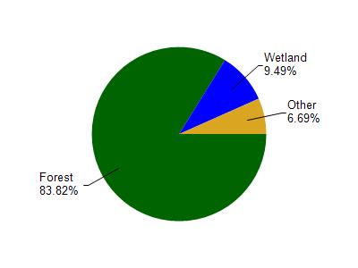
Upper Saint Croix Lake is located in the Upper St. Croix and Eau Claire Rivers watershed which is 277.89 mi². Land use in the watershed is primarily forest (83.90%), wetland (9.50%) and a mix of open (4.30%) and other uses (2.40%). This watershed has 153.93 stream miles, 7,654.41 lake acres and 13,694.48 wetland acres.
Nonpoint Source Characteristics
This watershed is ranked Not Ranked for runoff impacts on streams, Not Ranked for runoff impacts on lakes and Low for runoff impacts on groundwater and therefore has an overall rank of Low. This value can be used in ranking the watershed or individual waterbodies for grant funding under state and county programs.This water is ranked High Lake for individual Lakes based on runoff problems and the likelihood of success from project implementation.