Dane
No
No
No
Fish and Aquatic Life
Overview
Rock River Water Quality Management Plan, Lower Rock River Appendix. WT-668-2002. South Central Region, WDNR.
The Mendota Locks, also known as the Tenney Park Locks, is located at the outlet of Lake Mendota. The Yahara�s drainage area at this point is 233 square miles. The original Mendota Locks and Dam were constructed around 1847 for a flour mill. The City of Madison purchased the dam in 1896 and replaced the wooden dam with a concrete dam and constructed the lock. The existing lock and dam was constructed in 1959. Ownership of the lock and dam was transferred from the City of Madison to Dane County in 1980.
The lock and dam consists of a spillway with two 12-foot wide tainter gates, a 20-foot wide by 110-foot long lock, and has a 16 foot structural height but holds only a 5 foot head (difference of headwater and tailwater). It has a storage capacity of approximately 160,000 acre-feet between the bottom of the lock and the tip of the dam. Although the lake storage volume is approximately 440,000 acre-feet, only 160,000 acre-feet is actually impounded by the dam. Based on USGS data, the dam can pass a 100-year flood without overtopping. The probability of failure of the dam is low and according to a 1980 report, there is no evidence of structural problems. In the event of a dam failure, the flood wave would be greatly attenuated due to the storage capacities of Lakes Monona, Waubesa, and Kegonsa and is not expected to cause a failure of any downstream dams.
The Mendota Lock and Dam functions to aid recreation, maintenance of navigation between Lakes Mendota and Monona and stabilization of Lake Mendota water levels. Personnel operate the lock from May through October and the dam has a normal hydraulic head of 4-5 feet. The dam maintains the water level of Lake Mendota between a maximum of 850.1 feet, MSL datum, and a minimum of 849.6 feet during the summer. The winter minimum is 848.2 feet. Record levels occurred in 2000.
Date 2002
Author Aquatic Biologist
Overview
Lake Mendota At 9,842 acres, Lake Mendota is the largest of the Yahara lakes and almost three times larger than Lake Monona, with only a slightly greater depth. Mendota's shoreline development factor (DL) , which assesses the degree of irregularity in the shoreline and hence the potential for biological diversity (Lathrop, 1992) and development, is 1.57, versus a DL for Lake Kegonsa of 1.21 (1.0 is the value when a lake is a perfect circle). Thus, the lake's potential for diverse habitat in and near its bays and shallows is great. But the lake's wide littoral zone, combined with urban development in the immediate basin and agriculture throughout the watershed, has resulted in channels and embayments filling in and subsequent public requests for dredging for recreational motor craft access. Further, about 50 percent of original wetlands in the lake's watershed (which includes Six Mile and Pheasant Branch Creeks Watershed [LR10]) have been drained or filled (WDNR 1997).
Land use in the entire Lake Mendota watershed is comprised of 57.4 percent agriculture, 8.5 percent grassland/natural or wildlife areas, 1.4 percent woodlands, 20 percent developed, 5.7 percent wetland, and 6.9 percent open water. This mixture of agricultural, urban and other uses has changed from the agriculturally dominated watershed of the past (WDNR 1997). The lake's two watersheds (LR09 and LR10) include the urban areas of Middleton, Maple Bluff, Shorewood Hills, Waunakee, DeForest and large portions of Madison. Lathrop (1989b) observed that agricultural runoff is a much larger source of phosphorous to Lake Mendota than to the other Yahara Lakes because its drainage area is 4 to 5 times larger than the drainage area to the three other lakes. Lathrop (1992) also found, however, that although the total rural area is greater than the urban area in the Mendota watershed, the amount of phosphorus delivered per unit area of land is greater from urban land than from rural land. Soranno found that, in general, phosphorus from non-riparian rural areas is attenuated, while loads from urban areas, regardless of their location in the watershed, are not. Due to the rapid urbanization of land in the lake's watershed, a number of structural and nonstructural nutrient and sediment reduction and retention projects have been started. In Middleton and in Lottes Park, Madison, adjacent to Upper Mud Lake (LR08), nutrient retention ponds have been constructed. These best management practices are anticipated to reduce the lake's current inputs of nutrients and sediment. In 1990 and 1991, more than 310,000 gallons of untreated wastewater from Stokely's cannery operations in the village of Waunakee contributed excessively high nutrient, solids and BOD5 loads to Six Mile Creek, a direct tributary to Lake Mendota. The lake received these pollutants and the enhanced loads from the ensuing fish kills in the creek.
Despite these problems, in-lake recreation on Mendota is high and includes use of its warm water fishery (e.g., walleye, perch, panfish, bass, northern pike, and muskellunge), sailing, boating, jet skiing, sail boarding, and swimming. Use of Mendota and adjacent wetlands for aesthetic, shoreline and research activities is also popular. The waterbody is one of the most extensively-researched lakes in the United States. Water quality has improved in Lake Mendota during the last 25 years with reduced phosphorous loads resulting in improved water clarity. This, in part, has led to an increase in aquatic plant growth, particularly Eurasian water milfoil. Mechanical harvesting projects have been implemented yearly to remove this aquatic nuisance species.
Date 2002
Author Aquatic Biologist
Historical Description
Source: 1985, Surface Water Resources of Dane County,WI: WI-DNR Lake Mendota - T7N, R9E
Lake Mendota is a large, deep lake formed by morainic damming of the preglacial Yahara River. The present lake level is maintainedby the Tenney dam and locks creating a 3-ft head. Land use in the watershed is a combination of municipal and agricultural development. Water quality has improved slightly over the last 20 years due to an increased awareness of pollution sources and bypassing of sewage effluents, but blue-green algae blooms and excessive weed growth in the summer still occur as a result of land use practices in the watershed and its naturally fertile condition. The ratio of the drainage area to size of the lake is 30:1. Over 3 miles of shoreline are publicly owned, including a state park, a county park, six city parks, and land belonging to the University of Wisconsin. Wetlands are found at the Yahara River (Cherokee Marsh) and Six Mile Creek inlets, and in the University Bay area. Lake Mendota is noted as the most extensively researched body of water in the United States and has had a hydrobiology laboratory on its shore since the turn of the century. Excellent sailing, boating, swimming, and fishing are available on Lake Mendota. There are eight public swimming beaches and numerous boat launching sites. Ice fishing for perch and other panfish, and open water fishing for perch, crappies, and walleye are outstanding and attract thousands of anglers annually. Largemouth and smallmouth bass, panfish, northern pike, and recently stocked hybrid muskie are present in this major inland fishery. Cisco are increasing after a low period. Diversity of forage fish populations is great and a total of 63 species of fish have been collected in Lake Mendota through the years. Thirty-four species are commonly found. Fish species: lake sturgeon, longnose gar, bowfin, cisco, northern pike, hybrid muskie, common carp, golden carp, emerald and spotfin shiner, bluntnose and fathead minnow, white sucker, bigmouth buffalo, black, yellow, and brown bullhead, channel catfish, banded killifish, brook silverside, white and rock bass, green sunfish , pumpkinseed, bluegill, smallmouth and largemouth bass, white and black crappie, yellow-perch, logperch, walleye, and freshwater drum.
Surface acres = 9,842, SDF = 1.66, Maximum depth = 82 ft
Date 1985
Author Surface Water Inventory Of Wisconsin
General Condition
Lake Mendota Hoofers Dock Beach was assessed for the 2018 listing cycle; E. coli data sample data were clearly below the 2018 WisCALM listing thresholds for the Recreation use. This beach was meeting this designated use and was not considered impaired.
Date 2017
Author Ashley Beranek
General Condition
Lake Mendota James Madison Park Beach was assessed for the 2018 listing cycle; E. coli data sample data were clearly below the 2018 WisCALM listing thresholds for the Recreation use. This beach was meeting this designated use and was not considered impaired.
Date 2017
Author Ashley Beranek
General Condition
Lake Mendota Warner Park Beach was assessed for the 2018 listing cycle; E. coli data sample data were clearly below the 2018 WisCALM listing thresholds for the Recreation use. This beach was meeting this designated use and was not considered impaired.
Date 2017
Author Ashley Beranek
General Condition
Lake Mendota Marshall Park Beach was assessed for the 2018 listing cycle; E. coli data sample data were clearly below the 2018 WisCALM listing thresholds for the Recreation use. This beach was meeting this designated use and was not considered impaired.
Date 2017
Author Ashley Beranek
General Condition
Lake Mendota Memorial Union Pier Beach was assessed for the 2018 listing cycle; E. coli data sample data were clearly below the 2018 WisCALM listing thresholds for the Recreation use. This beach was meeting this designated use and was not considered impaired.
Date 2017
Author Ashley Beranek
General Condition
Lake Mendota Maple Bluff Beach was assessed for the 2018 listing cycle; E. coli data sample data were clearly below the 2018 WisCALM listing thresholds for the Recreation use. This beach was meeting this designated use and was not considered impaired.
Date 2017
Author Ashley Beranek
General Condition
During the 25-year-period of water quality improvement there were a number of years with lower than average spring runoff. Increased runoff from high water years (1993, 1996) and continued urban growth may have increased annual phosphorous loads, causing water quality to decline. One study has found, however, an inverse relationship between the heterogeneity of the lake's riparian buffers to the incidence of blue-green algae blooms (Soranno). Mendota still experiences occasional blue-green algae blooms and excessive weed growth. Algae blooms are not, however, a recent phenomena in the Madison lakes; algae blooms were reported as early as 1888 on Lakes Mendota and Monona. A major blue-green algae bloom occurred in the spring of 1990, causing dissolved oxygen to drop to 1 mg/l in at least one portion of the lake. The dissolved oxygen standard for a warm water sport fishery lake is 5 mg/l. Late winter melt and stormwater runoff carrying large amounts of nutrients into the lake--climatic conditions that enhance internal cycling of sediment entrained phosphorus--and trophic conditions conducive to algal growth factored into the 1990 bloom.
Five major streams and two storm sewers contribute phosphorus, sediment and other constituents to the lake. In-lake chloride and sodium concentrations have risen over the last 30 years, though in Mendota are at levels below the other Yahara Lakes. Most of the lake's water quality problems can be linked to past and present rural and urban runoff carrying sediments, nutrients and, possibly, toxicants into the lake.
Lake Mendota is a priority watershed project with ongoing implementation work. Substantial financial resources have contributed to a greater understanding of pollutant sources, sinks and remediation and prevention strategies. A major focus of the Lake Mendota Priority Watershed Project is on sediment and phosphorus reductions from agricultural and urban sources, stormwater management, groundwater and wetland protection, and public education. The 1997 Priority Watershed Plan (in publication) has an excellent summary of wetlands in the basin. Interested readers are encouraged to obtain both this draft plan as well as the 1997 Lake Mendota Priority Watershed Appraisal Report. This watershed has also be chosen as a U.S. Natural Resources Conservation Service's EQIP project. This will provide additional financial resources for the installation of agricultural best management practices.
Date 2010
Author Aquatic Biologist
Impaired Waters
Gov Nelson State Park Beach, Lake Mendota, was evaluated for bacteria in the 2022 cycle; E. coli levels were above listing thresholds as outlined in 2022 WisCALM. This beach was added to the 2022 Impaired Waters List.
Date 2022
Author Ashley Beranek
Impaired Waters
Lake Mendota Tenny Park Beach was placed on the impaired waters list for Recreational Restrictions due to E. coli in 2014. The 2018 assessments showed continued Recreational Restrictions due to E. coli; new E. coli sample data clearly exceeded the 2018 WisCALM listing thresholds for the Recreation use. Based on the most updated information, no change in the existing impaired waters listing was needed.
Date 2017
Author Ashley Beranek
Impaired Waters
Lake Mendota Spring Harbor Beach was placed on the impaired waters list for Recreational Restrictions due to E. coli in 2014. The 2018 assessments showed continued Recreational Restrictions due to E. coli; new E. coli sample data clearly exceeded the 2018 WisCALM listing thresholds for the Recreation use. Based on the most updated information, no change in the existing impaired waters listing was needed.
Date 2017
Author Ashley Beranek
Impaired Waters
Lake Mendota (WBIC 805400) was placed on the impaired waters list for total phosphorus in 2012. The 2018 assessments showed continued impairment by phosphorus; total phosphorus sample data overwhelmingly exceeded the 2018 WisCALM listing thresholds for the Recreation use and Fish and Aquatic Life use. Based on the most updated information, no change in the existing impaired waters listing was needed.
Date 2017
Author Ashley Beranek
Impaired Waters
The 2016 assessments showed continued impairment by phosphorus; total phosphorus sample data overwhelmingly exceed 2016 WisCALM listing thresholds for the Recreation use and Fish and Aquatic Life use. Based on the most updated information, no change in existing impaired waters listing is needed.
Date 2015
Author Aaron Larson
Impaired Waters
Lake Mendota is listed as impaired due to fish consumption advisories based on PCB concentrations in fish tissue. This water was assessed during the 2012 listing cycle, and total phosphorus and chlorophyll sample data exceed 2012 WisCALM listing thresholds for the recreation use; however, the ongoing Clean Yahara Project to address nutrient loadings to this lake, so further data collection and evaluation was deemed warranted prior to listing the recrational use impairment.
Date 2013
Author Aquatic Biologist
Condition
Wisconsin has over 84,000 miles of streams, 15,000 lakes and milllions of acres of wetlands. Assessing the condition of this vast amount of water is challenging. The state's water monitoring program uses a media-based, cross-program approach to analyze water condition. An updated monitoring strategy (2015-2020) is now available. Compliance with Clean Water Act fishable, swimmable standards are located in the Executive Summary of Water Condition in 2018. See also the 'monitoring and projects' tab.
Reports
Recommendations
Aquatic Invasives Research
UNIVERSITY OF WISCONSIN-MADISON: Research on Spiny Waterflea in Madison Lakes. Research to gain better understanding of Spiny Waterfleas and aspects pertaining to invasion detection and prevention
Citizen-Based Stream Monitoring
Collect chemical, physical, and/or biological water quality data to assess the current overall stream health. The data can inform management decisions and may be used to identify impaired waters for biennial lists.
Data analysis, report production
Wisconsin's natural community validations project
Information and Education
It includes facilitating technical and citizen advisory committees as well as developing delisting strategies, standardized evaluation tools, and educational programs.
Lake Classification
Dane County Lake Classification-Phase 2: The Phase 1 classification grant classified all county lakes and streams. This grant will take the next step by developing a management program based on the classification.
Lake Classification
Dane County Department of Planning and Development will hire a project staff in order to develop a Lake Classification project, which is seen as the first step toward developing a consistent set of county-wide standards and procedures to protect Dane County Waters.
Land Acquisition
The goal of this project is to acquire the stream corridor, spring discharge areas, and riparian lands which have been flooded since the stream was dammed in 1850. This purchase (approximately 49 acres) will give resource managers the opportunity to greatly improve the water quality of Token Creek (the largest single contributor of baseflow to Lake Mendota) and to re-establish Token Creek as one of Southern Wisconsin's premier cold water resources.
Partnership Project
The City of Middleton will contract with the U.S. Geological Survey to monitor and model the surface and groundwater flow within a portion of the Pheasant Branch watershed to locate effective combination of storm water treatment and control sites within the North Fork to mitigate the impacts of urbanization on the quality and quantity of water reaching Lake Mendota.
Land Acquisition
Hoover Property. The City of Madison Parks Division proposes to acquire the property at 628 East Gorham Street, adjacent to James Madison Park to expand the park for passive recreation and for lake protection. The building will be demolished and the hillside will be restored to natural vegetation.
Nine Key Element Plan
Lake Mendota PWS Plan - The purpose of this watershed plan is to assess the nonpoint pollutants in the Lake Mendota watershed and to guide the implementation of control measures. Implementation of best management practices to control polluted runoff and education are needed to meet very specific water resource objectives designed to protect and enhance Lake Mendota and other lakes, streams, groundwater, and wetlands in the watershed.
Action Migrated from WATERS
The cities of Madison, Monona and Fitchburg, and Dane County, should improve enforcement of their construction site erosion control ordinances.
Fish Management, Access
Dane County should work with WDNR to establish water levels that accommodate northern pike spawning habitat and improved water quality on tributaries to the Madison Lakes.
Management Goals
Wisconsin's Water Quality Standards provide qualitative and quantitative goals for waters that are protective of Fishable, Swimmable conditions [Learn more]. Waters that do not meet water quality standards are considered impaired and restoration actions are planned and carried out until the water is once again fishable and swimmable
Management goals can include creation or implementation of a Total Maximum Daily Load analysis, a Nine Key Element Plan, or other restoration work, education and outreach and more. If specific recommendations exist for this water, they will be displayed below online.
Watershed Characteristics
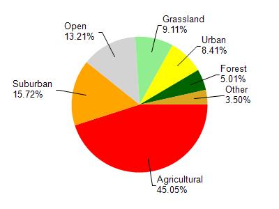
Lake Mendota is located in the Six Mile and Pheasant Branch Creeks watershed which is 119.45 mi². Land use in the watershed is primarily agricultural (45%), suburban (15.70%) and a mix of open (13.20%) and other uses (26.00%). This watershed has 145.61 stream miles, 9,959.08 lake acres and 2,759.80 wetland acres.
Nonpoint Source Characteristics
This watershed is ranked Not Available for runoff impacts on streams, Not Available for runoff impacts on lakes and High for runoff impacts on groundwater and therefore has an overall rank of High. This value can be used in ranking the watershed or individual waterbodies for grant funding under state and county programs.However, all waters are affected by diffuse pollutant sources regardless of initial water quality. Applications for specific runoff projects under state or county grant programs may be pursued. For more information, go to surface water program grants.