Douglas
No
No
Yes
Fish and Aquatic Life
Overview
The St. Louis River is the largest tributary stream entering Lake Superior from the United States. Most of its 3,442-square mile watershed drains Minnesota. After descending the Duluth escarpment at Fond du Lac, MN, the river becomes a meandering estuary with little current due to the geologic drowning of its river valley beneath the waters of Lake Superior, creating a natural harbor at its mouth. The lower 23-mile reach of the river bounds Wisconsin and Minnesota. Numerous islands and embayments characterize this part of the river. Among the larger bays in Wisconsin are St. Louis Bay, Superior Bay and Allouez Bay.
The harbor area of the St. Louis River Estuary has experienced extensive impacts due to human activity. Many of these are discussed under the St. Louis River RAP, or under individual stream discussions. Hog Island Inlet is discussed under the Newton Creek heading.
The river is the most seriously polluted waterbody in Douglas County and among the most polluted in the state. Historically, fish kills were common due to depleted oxygen from inadequately treated municipal and industrial wastes. The condition was aggravated by hydropower impoundments and fluctuating water levels due to peaking operations. Many of these issues have been addressed through the RAP. Severe erosion of red clay soils in the watershed continues to lead to extreme harbor sedimentation.
The RAP identified failing septic systems in the communities of Oliver, WI and Fond du Lac, MN that allow inadequately treated wastewater to enter the river. WDNR has accepted the village of Oliver's facility plan concept to resolve the problem with a centralized collection system and regional treatment by the Western Lake Superior Sanitary District facility in Duluth.
In 1993, WDNR's hazardous waste section conducted an inspection of Fraser Shipyards in Howards Bay, just east of Interstate Island. The inspection revealed several alleged environmental violations including illegal treatment and storage of hazardous waste. Samples of sand-blasting grit in the floor of Dry Dock Number 1 exceeded regulatory levels for lead and the contaminated grit was therefore considered a characteristic hazardous waste. Samples of sediment in Howards Bay were collected by WDNR, Minnesota Pollution Control Agency, U.S. EPA and a consultant hired by Fraser. The sampling indicates lead concentration at levels toxic to environmental organisms in surface sediments, generally decreasing in levels with distance from Dry Dock Number 1. Sediment issues are being handled by the state Department of Justice (Liebenstein).
The estuary is a tremendous resource for wildlife, with its backwaters and islands providing nesting habitat for numerous waterfowl and other birds, as well as nursery and spawning areas for aquatic life.
Near the village of Oliver along the river, an area of wetland and shallow water habitat lies just down river from the mouth of the Red River and the St. Louis River Streambank Protection Area. The Lake Superior Binational Program identified this area as important to the integrity of the Lake Superior ecosystem for coastal wetlands and contribution to ecosystem integrity - landscape scale.
Interstate Island, a 200-acre island in St. Louis Bay shared between the two states, was identified by the Lake Superior Binational Program as habitat important to the integrity of the Lake Superior ecosystem. The island is a colonial bird nesting site for common terns, one of only four locations in Wisconsin where this state endangered species nests. The island is identified as important for its threatened or endangered species habitat, fish and wildlife spawning and nursery grounds and vital functions for planning objectives.
http://www.stlouisriver.org/
Date 2009
Author Aquatic Biologist
Historical Description
The estuary is a tremendous resource for wildlife, with its backwaters and islands providing nesting habitat for numerous waterfowl and other birds, as well as nursery and spawning areas for aquatic life.
Near the village of Oliver along the river, an area of wetland and shallow water habitat lies just down river from the mouth of the Red River and the St. Louis River Streambank Protection Area. The Lake Superior Binational Program identified this area as important to the integrity of the Lake Superior ecosystem for coastal wetlands and contribution to ecosystem integrity - landscape scale.
Interstate Island, a 200-acre island in St. Louis Bay shared between the two states, was identified by the Lake Superior Binational Program as habitat important to the integrity of the Lake Superior ecosystem. The island is a colonial bird nesting site for common terns, one of only four locations in Wisconsin where this state endangered species nests. The island is identified as important for its threatened or endangered species habitat, fish and wildlife spawning and nursery grounds and vital functions for planning objectives.
The portion of the river in Wisconsin has historically supported a warm water sport fishery. As far back as 1860, walleye were harvested commercially in the river. Other fish historically found in the river include northern pike, yellow perch, white sucker, longnose sucker and a variety of minnows, muskellunge, smallmouth bass, black crappie, rock bass, pumpkinseed, yellow, black and brown bullhead, silver and shorthead redhorse, burbot channel catfish and lake sturgeon.
During survey work conducted as part of the coastal wetlands evaluation, the richness of macroinvertebrate taxa was determined to be moderate, though it contained eight taxa that were unique to the river among the 161 streams sampled in the study (Epstein 1997). Large wetland complexes along the river are also identified in the evaluation as Priority Wetlands and are discussed in detail, above. Surveyers identified significant contributions to water quality condition due to sludge, impoundment, exotics and point sources, with lesser contributions from silt, septic systems and streambank erosion. Significant turbidity and plant growth occurred with filamentous algae present (Epstein 1997).
Wetlands along the St. Louis River were identified as Priority Wetlands in the coastal wetlands evaluation and are described in detail under Resources of Concern, above.
Development threatens wetlands in the estuary and harbor area. More than half of the wetland and open water habitat has been lost (Epstein 1996). A portion of the emergent wetland loss is likely due to natural causes created by the gradual sinking of the western portion of Lake Superior relative to the eastern portion, and the slow drowning of the St. Louis estuary (Pratt 1996). A number of plans in place or in development aim to protect what remains.
Date 1999
Author Aquatic Biologist
Recommendations
Monitor Aquatic Biology
Biota in the lower St. Louis River (estuary) will be sampled and tested for total and methyl mercury content. Burrowing mayflies will be the primary target organism. Composite samples will be collected from 88 sites.
Monitor Targeted Area
Assess levels of contaminants of emerging concern in the St. Louis River.
Master Planning
Develop and implement the St. Louis River Comprehensive Delisting Framework. The Delisting Framework is a project that will allow the state to outline its priority actions to make progress in delisting the AOC.
Management Plans
Wisconsin Point and Allouez Bay were identified as Priority Wetlands by the coastal wetlands evaluation.
The city of Superior's 4,500-acre municipal forest borders the St. Louis River estuary and includes Kimballs Bay, Dwights Point and Pokegama Bay. The Dwights Point-Kimballs Bay area includes a two-mile long peninsula into the St. Louis River estuary. The peninsula, Dwights Point, contains old-growth red and white pine among second growth mixed woodland, representing some of the best boreal forest remaining in Wisconsin's Lake Superior region. Kimballs and Pokegama Bays are long, serpentine bays. Pokegama Bay spans some 200 acres. Wetlands and emergent aquatic vegetation line the bays, which are used extensively by waterfowl. These public lands were identified by the Lake Superior Binational Program as habitat important to the integrity of the Lake Superior ecosystem for old growth forest, coastal wetlands and contribution to ecosystem integrity - landscape scale.
The Superior Municipal Forest was also identified as a Priority Wetland site during the coastal wetland evaluation and is described in detail under Resources of Concern, above.
Date 1999
Author Aquatic Biologist
Monitoring
Monitoring the condition of a river, stream, or lake includes gathering physical, chemical, biological, and habitat data. Comprehensive studies often gather all these parameters in great detail, while lighter assessment events will involve sampling physical, chemical and biological data such as macroinvertebrates. Aquatic macroinvertebrates and fish communities integrate watershed or catchment condition, providing great insight into overall ecosystem health. Chemical and habitat parameters tell researchers more about human induced problems including contaminated runoff, point source dischargers, or habitat issues that foster or limit the potential of aquatic communities to thrive in a given area. Wisconsin's Water Monitoring Strategy was recenty updated.
Grants and Management Projects
Monitoring Projects
| WBIC | Official Waterbody Name | Station ID | Station Name | Earliest Fieldwork Date | Latest Fieldwork Date | View Station | View Data |
|---|
| 2751220 | Lake Superior | 10042000 | Lake Superior Cummings Slip (02) | 10/30/2007 | 10/30/2007 | Map | Data |
| 2751220 | Lake Superior | 10058946 | N Howard's Bay St. Louis River | | | Map | Data |
| 2751220 | Lake Superior | 10012209 | Lake Superior - Fraser Shipyard Superior North Of Office Bldg. East Of Slip By Office | 5/7/1993 | 5/7/1993 | Map | Data |
| 2751220 | Lake Superior | 10012210 | Lake Superior - Fraser Shipyard Superior North West Of Sample #Jm3 | 5/7/1993 | 5/7/1993 | Map | Data |
| 2751220 | Lake Superior | 10012208 | Lake Superior - Fraser Shipyard Superior Channel Betw. E & W Drydocks | 5/7/1993 | 5/7/1993 | Map | Data |
| 2751220 | Lake Superior | 10043827 | Lake Superior at Howards Bay - Fraser Slip | 6/25/2015 | 6/22/2017 | Map | Data |
| 2751220 | Lake Superior | 10058949 | S Howard's Bay St. Louis River | | | Map | Data |
| 2751220 | Lake Superior | 10043826 | Lake Superior at Howards Bay - Cummings Ave Slip | 6/23/2015 | 6/22/2017 | Map | Data |
| 2751220 | Lake Superior | 163103 | Superior Distribution System | | | Map | Data |
| 2751220 | Lake Superior | 10034506 | HOWARDS BAY (SITE 38) BLW BLATNIK BRG AT SUPERIOR (USGS station 464429092054601) | 10/8/2010 | 10/8/2010 | Map | Data |
| 2751220 | Lake Superior | 163418 | Superior Harbor - Interstate | | | Map | Data |
| 2751220 | Lake Superior | 10041999 | Lake Superior Cummings Slip (01) | 10/30/2007 | 10/30/2007 | Map | Data |
| 2751220 | Lake Superior | 10012211 | Lake Superior - Fraser Shipyard Superior Outside East Drydock Gate | 5/7/1993 | 5/7/1993 | Map | Data |
| 2751220 | Lake Superior | 10046384 | Phragmites Occurrence - Lake Superior | | | Map | Data |
| 2751220 | Lake Superior | 163072 | Duluth Harbor - Anchorage Area | 5/11/1976 | 5/26/1977 | Map | Data |
| 2751220 | Lake Superior | 10043825 | Lake Superior at Howards Bay - Hughitt Ave Slip | 6/23/2015 | 6/25/2015 | Map | Data |
| 2751220 | Lake Superior | 163071 | Superior Harbor - Off Conners Pt | 5/11/1976 | 7/21/1977 | Map | Data |
| 2751220 | Lake Superior | 10042001 | Lake Superior Cummings Slip (03) | 10/30/2007 | 10/30/2007 | Map | Data |
| 2751220 | Lake Superior | 10043806 | Lake Superior at Howards Bay - Dock St grain silos to Lamborn Ave | 8/18/2014 | 7/21/2021 | Map | Data |
| 2751220 | Lake Superior | 10052175 | St. Louis River AOC - WDNR18-TB-2 | 8/15/2018 | 8/15/2018 | Map | Data |
| 2751220 | Lake Superior | 163040 | Superior Water Light And Pwr 001 | | | Map | Data |
| 2751220 | Lake Superior | 10012212 | Lake Superior - Fraser Shipyard Superior Outside West Drydock Gate | 5/7/1993 | 5/7/1993 | Map | Data |
| 2751220 | Lake Superior | 10052176 | St. Louis River AOC - WDNR18-TB-3 | 8/15/2018 | 8/15/2018 | Map | Data |
| 2751220 | Lake Superior | 10052177 | St. Louis River AOC - WDNR18-TB-4 | 8/15/2018 | 8/15/2018 | Map | Data |
| 2751220 | Lake Superior | 10052174 | St. Louis River AOC - WDNR18-TB-1 | 8/15/2018 | 8/15/2018 | Map | Data |
|
Watershed Characteristics
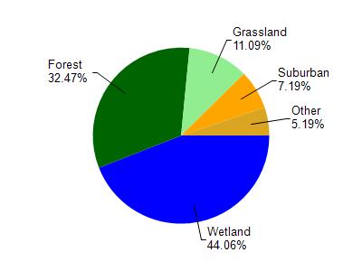
Saint Louis River is located in the St. Louis and Lower Nemadji River watershed which is 159.67 mi². Land use in the watershed is primarily wetland (44.10%), forest (32.50%) and a mix of grassland (11.10%) and other uses (12.40%). This watershed has 432.66 stream miles, 8,490.75 lake acres and 26,945.85 wetland acres.
Nonpoint Source Characteristics
This watershed is ranked Not Ranked for runoff impacts on streams, Not Available for runoff impacts on lakes and Low for runoff impacts on groundwater and therefore has an overall rank of Low. This value can be used in ranking the watershed or individual waterbodies for grant funding under state and county programs.However, all waters are affected by diffuse pollutant sources regardless of initial water quality. Applications for specific runoff projects under state or county grant programs may be pursued. For more information, go to surface water program grants.