Forest, Oneida
No
No
No
Fish and Aquatic Life
Overview
Eagle River, in the Eagle River and Sugar Camp Creek Watersheds, is a 40.81 mile river that falls in Forest, Oneida and Vilas Counties. This river is managed for fishing and swimming and is currently not considered impaired.
Date 2011
Author Aquatic Biologist
Recommendations
Lakes Protection Grant
Phases V & VI, Three Lakes Waterfront Association, Inc. is sponsoring a lake protection grant to study Little Fork, Medicine, Round, Island, and Townline Lakes, in Oneida County. The project will focus on developing a Lake Management Plan (LMP) for each lake and the Three Lakes Chain.
Lake Management Plan Implementation
The Town of Washington is sponsoring a project on Anvil Lake, Vilas County. The project will focus on studying water quality and developing an Anvil Lake Management Plan (LMP). Project activities include: 1) Develop water and P budget; 2) Water quality evaluation and groundwater assessment; 3) WiLMS simulation modeling; 4) Stakeholder participation; 5) Collect sediment cores for historical and future lake water quality assessment; 6) Implementation of County sewage ordinance and association shoreline restoration project; 7) Develop annual reports, a scientific investigations report and LMP.
Educate and engage residents
The Northwoods Land Trust will conduct a direct-mail education campaign to all property owners on priority river and stream segments in Vilas County that were identified by the DNR Northern Rivers Initiative. An information packet will be provided highlighting voluntary conservation options property owners can utilize to protect the priority river and stream corridors. These options include Land Protection Agreement (Conservation Easement), Land Donation, Land Registry and Conservation Buyer programs. Specific activities will be: * Identify all property owners with natural shoreland frontage along all of the priority river and stream segments in Vilas County. * Assemble and mail information packets on conservation options to all identified property owners. * Follow-up contacts with interested landowners to provide legal and technical assistance for conservation options. Specific products or deliverables will include: * Maps showing parcels with existing natural shoreline. * Generalized list of landowner follow-up contacts. It is anticipated this project will result in one or more landowner commitment to donate a conservation easement to permanently protect their river or stream shoreline but this result can not be guaranteed.
Monitor Water Quality or Sediment
"The data from 2011 and 2015 appear to meet the minimum data requirements and show an impairment for a two-story lake.
Deer Lake is part of the Three Lakes Chain which contains multiple two-story lakes. However, the bathymetry of Deer Lake itself would not support a two-story fishery. Cisco are a transient fish in the lake according to the DNR two-story fishery list. "
Agree that this is a transient two-story fishery. TP is still high enough to be listed, but recommend further monitoring in the future.
Monitor Water Quality or Sediment
"The data from 2011 and 2015 appear to meet the minimum data requirements and show an impairment for a two-story lake.
Dog Lake is part of the Three Lakes Chain which contains multiple two-story lakes. However, the bathymetry of Dog Lake itself would not support a two-story fishery. Cisco are a transient fish in the lake according to the DNR two-story fishery list."
Agree that this is a transient two-story fishery. TP is still high enough to be listed, but recommend further monitoring in the future.
Management Goals
Wisconsin's Water Quality Standards provide qualitative and quantitative goals for waters that are protective of Fishable, Swimmable conditions [Learn more]. Waters that do not meet water quality standards are considered impaired and restoration actions are planned and carried out until the water is once again fishable and swimmable
Management goals can include creation or implementation of a Total Maximum Daily Load analysis, a Nine Key Element Plan, or other restoration work, education and outreach and more. If specific recommendations exist for this water, they will be displayed below online.

Watershed Characteristics
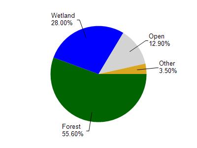
Eagle River is located in the Eagle River watershed which is 181.70 mi². Land use in the watershed is primarily forest (55.60%), wetland (28%) and a mix of open (12.90%) and other uses (3.50%). This watershed has 146.13 stream miles, 15,720.03 lake acres and 32,094.84 wetland acres.
Nonpoint Source Characteristics
This watershed is ranked Not Ranked for runoff impacts on streams, High for runoff impacts on lakes and Low for runoff impacts on groundwater and therefore has an overall rank of Low. This value can be used in ranking the watershed or individual waterbodies for grant funding under state and county programs.However, all waters are affected by diffuse pollutant sources regardless of initial water quality. Applications for specific runoff projects under state or county grant programs may be pursued. For more information, go to surface water program grants.