Florence, Marinette
No
No
No
Fish and Aquatic Life
Overview
The Menominee River originates just north of this watershed near Florence, WI at the confluence of the Brule River (GB18) and Michigan's Michigamme River. The Menominee flows southerly for 118 miles before joining the waters of Green Bay. Hydroelectric development has been extensive along the Menominee River.
Dams have converted 37 percent of the river mileage to impoundments, primarily in areas of higher gradient. More than 70 percent of river with a gradient greater than four feet per mile has been flooded by dam development. These high gradient reaches are the most productive in terms of aquatic insects and are important for fish spawning habitat. Losses of high gradient rapids in this watershed include: the Pemene Rapids, which drops 20 feet in two miles: the Chalk Hill Rapids, which drops eight feet in a half mile; and White Rapids, which drops 41 feet in four miles. A total of 6.75 miles of high gradient river, important as sport fish spawning areas, has been lost. Horse Race and Sturgeon Falls rapids have also suffered losses. Additionally, the river in this watershed suffers habitat degradation due to peaking in hydroelectric operations.
Lake sturgeon, walleye, largemouth bass, smallmouth bass, northern pike, muskellunge, yellow perch, panflsh, suckers, bullhead, carp and forage species are found in the Menominee River. Low levels of dioxin have been detected in large carp in the Norway-Quinnesec area. Although levels are less than the current "state action level," the presence of these compounds is a concern. Fish taste and odor problems have also been reported from this area of the river and are seriously impacting sport fishing. Initial testing indicates that the Champion Mill at Quinnesec, Michigan may be responsible, but further testing is underway to ascertain the exact cause and nature of the problem. The Menominee River is managed as a boundary water by Wisconsin and Michigan. A specific set of fishing regulations apply to the river. Fish managers and law enforcement personnel from both states develop these regulations to protect and conserve the aquatic resources of the river.
The 20 miles of river between Chalk Hills Flowage and Sturgeon Falls Dam is a beautiful and valuable resource. This section of river is mostly undeveloped with two natural water falls, Quiver Falls and Pemene Falls. Numerous rock outcrops, rapids, and deep pools make this one of the most scenic sections of the Menominee River. Most of the riparian property is owned by power companies.
In the last century, sawmills deposited sawdust and slabwood directly in the river and in adjacent marshes. Many of these wastes are still present today. Dissolved oxygen levels below the 5 parts per million state water quality standard have been found below the White Rapids and Little Quimesec hydroelectric dams.
Date 1993
Author Aquatic Biologist
Historical Description
Wisconsin and Michigan, with support and cooperation from local communities, the U.S. Environmental Protection Agency (EPA) and the International Joint Commission (IJC) of Canada and the United States are developing a remedial action plan (RAP) for the lower three miles of the Menominee River and adjacent Green Bay shoreline. The area has been designated by IJC as one of 43 Great Lakes Area of Concern, so identified because of use impairments due to water quality. The purpose of the plan is to address and eventually clean up contamination problems which persist in the river despite the considerable efforts and money already spent to remedy water pollution problems. Once the RAP is completed and formally approved, it will become an amendment to this WQM plan. Additional information on Great Lakes RAPS is available in the brochure Remedial Action Plans for Areas of Concern published by the International Joint Commission and available from DNR and in the 1992 Wisconsin Water Quality Assessment Report to Congress.
Impaired uses identified in the Lower Menominee River RAP include:
* restricted dredging,
* restricted fish consumption,
* degraded fish and wildlife habitat,
* degraded fish populations,
* degraded communities of bottom-dwelling organisms, and
* total and partial body contact restrictions.
Toxic pollutants in the sediments are a major concern in the lower Menominee River. The in-place pollutants in some of the sediment deposition zones in the river include arsenic, oil and grease, phosphorus, ammonia-nitrogen, cyanide, lead, manganese, cadmium, mercury, copper and zinc. Arsenic is found at elevated concentrations in the turning basin area of the river, adjacent to Ansul Fire Protection's property. A facility investigation and corrective measures study of the site are under development through the federal Resource Conservation and Recovery Act (RCRA) program. This program includes assessing the extent and impact of the contamination and, if necessary, implementation of a corrective action plan.
Date 1993
Author Surface Water Inventory Of Wisconsin
Historical Description
Monitoring recommendations in this WQM plan will assist in developing assessment and remediation strategies. A recent invader in the Great Lakes, zebra mussels, have spread into the waters of Green Bay and have moved into inland waters. Zebra mussels pose a threat to water intake systems, which become clogged with the mussels, and have been known to impact recreational activities such as boating and fishing. The mussel has qulckly spread since the first adult mussels were discovered in Lake Michigan in 1990. A mature mussel can produce 30,000 to 40,000 eggs per season and the mussels can survive out of water as long as 30 days, leading to the potential for further introduction into inland waters as boats are moved from waterbody to waterbody. There are three hydroelectric dams operating on this portion of the Menominee River. The upper and lower Scott dams are owned and operated by Scott Paper Company. The Grand Rapids dam is owned and operated by Wisconsin Public Service. The latter dam inundates a two-mile stretch of rapids, which historically was a major spawning area for many fish species including lake sturgeon. Data from the USGS gauging station downstream of Grand Rapids indicate flows in the river fluctuate as a result of dam operations. The facility is not operating in a peaking mode: however, the flows are not run-of-river flows. An application for relicensing of the Grand Rapids dam was submitted to the Federal Energy Regulatory Commission (FERC) in 199 1. Additional information on the impoundments created by these dams is included in the Lakes Report. For more information see the original document.
Date 1993
Author Surface Water Inventory Of Wisconsin
Recommendations
Restore Riparian Habitat
The goal is to revitalize the venerable lake sturgeon of Lake Michigan by reconnecting existing populations with historic spawning and rearing habitat in the Menominee River.
Sewer Service Area Planning
The City of Marinette planning area consists of approximately 25,421 acres (39 square miles) and is located in the southeastern portion of Marinette County. It is bordered to the north by the Menominee River and to the east by the bay of Green Bay.
Sediment Remediation Phase 5 - Implementation
Focused Non-Aqueous Phase Liquid (NAPL) and Sediment Removal Action. Remediation of Menominee River by MGP.
Monitor Fish Tissue
609000 name Menominee River TMDL ID 672 Start Mile 43.21 End Mile 87.8
Standards Details
This water, from the mouth to the Scott Dam (proposed CW addition).
Date 2010
Author Aquatic Biologist
Management Goals
Wisconsin's Water Quality Standards provide qualitative and quantitative goals for waters that are protective of Fishable, Swimmable conditions [Learn more]. Waters that do not meet water quality standards are considered impaired and restoration actions are planned and carried out until the water is once again fishable and swimmable
Management goals can include creation or implementation of a Total Maximum Daily Load analysis, a Nine Key Element Plan, or other restoration work, education and outreach and more. If specific recommendations exist for this water, they will be displayed below online.
Monitoring
Monitoring the condition of a river, stream, or lake includes gathering physical, chemical, biological, and habitat data. Comprehensive studies often gather all these parameters in great detail, while lighter assessment events will involve sampling physical, chemical and biological data such as macroinvertebrates. Aquatic macroinvertebrates and fish communities integrate watershed or catchment condition, providing great insight into overall ecosystem health. Chemical and habitat parameters tell researchers more about human induced problems including contaminated runoff, point source dischargers, or habitat issues that foster or limit the potential of aquatic communities to thrive in a given area. Wisconsin's Water Monitoring Strategy was recenty updated.
Grants and Management Projects
Monitoring Projects
| WBIC | Official Waterbody Name | Station ID | Station Name | Earliest Fieldwork Date | Latest Fieldwork Date | View Station | View Data |
|---|
| 609000 | Menominee River | 10019855 | Brule River/Menominee River -- Access | 7/5/2008 | 8/2/2008 | Map | Data |
| 609000 | Menominee River | 10029630 | Menominee R at Niagra Landing off CTH N | 6/29/2004 | 8/9/2004 | Map | Data |
| 609000 | Menominee River | 10003655 | Menominee River - 50 Above Hy 8 | | | Map | Data |
| 609000 | Menominee River | 10003654 | Menominee River - 10 Marinette | | | Map | Data |
| 609000 | Menominee River | 10042712 | Menominee River East of River Drive | 8/12/2014 | 1/1/2015 | Map | Data |
| 609000 | Menominee River | 10003661 | Menominee River - 51 Bel Quinissec Ml | | | Map | Data |
| 609000 | Menominee River | 10047223 | Twin Falls Flowage at Twin Falls Road | 9/10/2016 | 9/10/2016 | Map | Data |
| 609000 | Menominee River | 10029500 | Menominee River - Pine River confluence | 8/15/2007 | 9/9/2009 | Map | Data |
| 609000 | Menominee River | 10003664 | Menominee River - 60 Ltl Quinnesec Flow | | | Map | Data |
| 609000 | Menominee River | 10003656 | Menominee River - 09 Ansul Chem | | | Map | Data |
| 701900 | Twin Falls Flowage | 10047223 | Twin Falls Flowage at Twin Falls Road | 9/10/2016 | 9/10/2016 | Map | Data |
| 609000 | Menominee River | 10030553 | Menominee River -- Sportsman Lane Boat Ramp | 8/12/2009 | 5/31/2026 | Map | Data |
| 609000 | Menominee River | 10048376 | Menominee River Access off of Romitti Drive | 5/26/2017 | 5/24/2026 | Map | Data |
| 703900 | Brule River | 10019855 | Brule River/Menominee River -- Access | 7/5/2008 | 8/2/2008 | Map | Data |
| 609000 | Menominee River | 10044043 | Menominee River at N | | | Map | Data |
| 609000 | Menominee River | 10003660 | Menominee River - 09 Ansul Chem | | | Map | Data |
| 609000 | Menominee River | 10052190 | Menominee River at HWY 2 | 6/1/2018 | 6/1/2018 | Map | Data |
| 609000 | Menominee River | 10052189 | Menominee River DS Twin Falls Flowage Dam | 6/1/2018 | 6/1/2018 | Map | Data |
| 609000 | Menominee River | 193036 | Aurora Sanitary District #1 Stp | | | Map | Data |
| 609000 | Menominee River | 10003657 | Menominee River - 20 Hattie St | | | Map | Data |
| 609000 | Menominee River | 193001 | Menominee River at Hwy 2-141 Lower | | | Map | Data |
| 609000 | Menominee River | 10003650 | Menominee 09 Below Ansul Chem | | | Map | Data |
| 609000 | Menominee River | 10029502 | Menominee River - Cowboy Lake (MI) outlet | 8/15/2007 | 9/9/2009 | Map | Data |
|
Watershed Characteristics
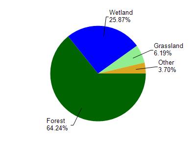
Menominee River is located in the Pemebonwon and Middle Menominee Rivers watershed which is 290.80 mi². Land use in the watershed is primarily forest (64.30%), wetland (25.90%) and a mix of grassland (6.20%) and other uses (3.70%). This watershed has 341.53 stream miles, 1,078.33 lake acres and 37,891.92 wetland acres.
Nonpoint Source Characteristics
This watershed is ranked Unknown for runoff impacts on streams, Unknown for runoff impacts on lakes and Unknown for runoff impacts on groundwater and therefore has an overall rank of Unknown. This value can be used in ranking the watershed or individual waterbodies for grant funding under state and county programs.However, all waters are affected by diffuse pollutant sources regardless of initial water quality. Applications for specific runoff projects under state or county grant programs may be pursued. For more information, go to surface water program grants.