Project description
Rock River Recovery Project Portal
Welcome to the Rock River Recovery project portal page. Here you can access detailed information to answer most questions about the Rock River TMDL including:
Rock River Recovery Main PageProject goals

The Rock River Recovery is the official restoration program for impaired waters in the Rock River Basin. In accordance with the Clean Water Act, the WDNR has the following three responsibilities, and associated authority to conduct them;
- Develop water quality criteria to protect the designated uses of waters in the state,
- Inventory waters and identify those that are impaired and fail to provide their designated uses, and
- Develop Total Maximum Daily Loads for pollutants causing impairments.
Rock River Recovery Goal:
- To Restore the Designated Uses of Impaired Waters in the Rock River Basin.
Contacts
The most current information is posted monthly, via the Rock River Recovery Newsletter (click link to subscribe, view previous issues under the News Tab). Additional information on the history of the TMDL, technical details, an implementation are available from the other tabs on this page. For more specific questions, please feel free to contact the team members, below;
Recent events

Rock River Recovery TMDL Implementation Update - 2019
For 2019, we are currently working on summarizing efforts in Wisconsin, and especially in the top 10 focus basins, including the Rock River Basin. One effort is to better represent activities using mapping to illustrate where and how efforts are being undertaken. The above image is a draft example and ranks all of the 120 HUC-12 watersheds in the Rock River Basin based on how many of the following initiatives and activities exist within each HUC-12:
- Past Priority Watershed Restoration Project
- Current Nine-Key Element Watershed Restoration Plan
- Active Farmer-led Watershed Group
- Point Source Discharge Facility with TMDL Limits
- Watershed-based Permit Compliance Projects
The Rock River Recovery Team publishes monthly newsletters to provide updates and share information pertinent to implementation of the TMDL -
subscribe by clicking on the link at right:
Beaver Dam Lake Total Maximum Daily Load for Total Phosphorus
A proposed update to the Rock River TMDL, to draft a TMDL specific to Beaver Dam Lake, was published for public comment and review on April 9, 2018 (with public comment through May 8, 2018). Following receipt of public comments and subsequent revisions, the final
"Beaver Dam Lake Total Maximum Daily Load for Total Phosphorus, June 20, 2018", was submitted to EPA for review, as an amendment to the
"Total Maximum Daily Loads for Total Phosphorus and Total Suspended Solids in the Rock River Basin, July 2011". As of August 17, 2018, EPA has formally approved this amendment. See below for related documents and supporting materials;
Monthly Newsletters (Gov Delivery)
- 2019: target="_blank">May, April, March, February, January
- 2017: December, November, October, September, August, July, June, May, April, March, February, January
- 2016: December, November, October, Stakeholder Survey, August, July, June, May, April, March, February, January
- 2015: December, November, October, September, August, July, June, May, April, January
- 2014: December, October, September, August - Annual Meeting Announcement
Final TMDL report
The Rock River TMDL was officially approved by the USEPA on September 2011. The TMDL is a Total Maximum Daily Load allocation for Total Phosphorus (TP) and Total Suspended Solids (TSS) in the Rock River Basin, including Columbia, Dane, Dodge, Fond du Lac, Green Lake, Jefferson, Rock, Walworth, Washington, and Waukesha Counties, Wisconsin. While the Rock River TMDL was developed to address impairments to designated uses of streams, rivers and lakes in the Rock River Basin, the TMDL analysis that was conducted included ALL waters within the Rock River Basin. By utilizing this approach, the TMDL also serves to protect unimpaired waters, as well as downstream receiving waters.
The Rock River TMDL study broke rivers and streams into unique segments based on a number of factors. Some of these include location of confluence points, significant changes in hydrographic setting, and locations of other potential "change" points. Consequently, the individual rivers and streams are comprised of numerous segments. As of the most recent biennial assessment period (2016), there were 229 discrete segments in the basin that are on the 303(d) list of impaired waters.

The TMDL analysis identified the pollutants of concern (TP and TSS), as well as the sources of these pollutants, both point sources and nonpoint sources. These pollutants are known to contribute to low dissolved oxygen, degraded habitat and excessive turbidity in waterways, resulting in harm to fish and aquatic life, water quality, recreation and even navigation. The TMDL provides a quantitative analysis of the amounts AND timing of sediment and/or phosphorus that the waterbodies can receive from both point and nonpoint sources and still meet water quality standards (assimilative capacity).
The graphs at right (from the TMDL) summarize the results of the 10 year TMDL analysis period (1989-1998). The annual TP results (upper left) indicate agriculture is, on average, responsible for 64% of TP load (mostly particulate). However, what is hidden by this figure is the vast majority of this TP came from just a couple of very large events in a specifically bad runoff year. For many of the years and most rain events (<0.25"), little or no runoff was generated from agricultural lands. Conversely, impervious urban areas generate runoff from almost every rain event. Looking at monthly data (lower left), the patterns change, and point sources are by far the largest contributor of TP (largely dissolved) and this is during late summer when flows and assimilative capacity are low.
Assimilative Capacity: The ability of a body of water to receive pollutants; its capacity to receive waste waters or materials without deleterious effects to designated uses.
The MOST IMPORTANT LESSON from the TMDL is:
- EVERYONE contributes to our water quality challenges in the Rock River Basin and we must all work together to restore our waters.
USEPA decision document
The TMDL states that the Rock River Basin is located in southern Wisconsin and includes drainage from seven subbasins and watersheds: the Upper Rock, Middle Rock, Afton, Yahara, Crawfish and Bark Rivers, and Turtle Creek. There are 83 reaches and numerous lakes included in the areal extent of this TMDL, with 61 of these reaches and one lake that are determined to be impaired by the Wisconsin Department of Natural Resources (WDNR), for a total of62 impaired waterbodies. The impaired waters are included in the TMDL submittal which is incorporated by reference. The Table includes the name of the impaired water, the river mile location, county, identification number, pollutants, impairments, and designated use. Two ofthe waterbodies, Lake Koshkonong and Lake Sinnissippi, are impoundments on the Rock River and do not have sufficient detention time to be considered reservoirs or lakes. Therefore, these waterbodies are classified as rivers when applying standards. For purposes of description, Lake Koshkonong and Lake Sinnissippi are referred to as "lakes" in the TMDL submittal; however, only Fox Lake is a true lake and as such has an applicable water quality standard for lakes. This submittal includes 101 TMDLs for Total Phosphorus (TP) and Total Suspended Solids (TSS). There are 39 segments/lakes listed as impaired for both contaminants (78 TMDLs), 20 for only TSS, and 3 for only TP. These TMDLs address degraded habitat, low Dissolved Oxygen (DO), eutrophication, and turbidity impairments.
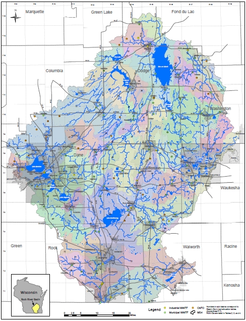
The entire watershed covers 3750 sq. mi. in Dodge, Jefferson, Rock, Dane, Columbia, Fond du Lac, Washington, Walworth, Waukesha, Green and Green Lake Counties. Section 2.1 of the TMDL states that there are approximately 3,900 river miles draining the study area. The 62 impaired waters are shown in TMDL map. The seven subbasins are shown in Figure 1 on page four of this document (Figure 2 of the TMDL). The largest surface water features are Horicon Marsh, Beaver Dam Lake, Lake Sinissippi, Lake Koshkonong, the Yahara Chain ofLakes, Oconomowoc Lake, and Lake Delavan, and 443 total lakes and impoundments in the basin.
USEPA Decision Document for the Rock River TMDL was issued in 2013
Technical presentations
The following presentations and factsheets explain the TMDL.
Restoring Rock River Basin [PDF]
Rock River Basin TMDL Overview [PDF]
Rock River Recovery Implementation [PDF]
Archives
- 2011: Rock River TMDL Educational Forums
Technical memos
Resource conditions
 The Rock River Basin is located in southern Wisconsin. Several lakes, rivers, and streams in the Rock River Basin are impaired by excessive phosphorus and sediment concentrations, which lead to nuisance algae growth, oxygen depletion, reduced submerged aquatic vegetation, water clarity problems, and degraded habitat. These impairments adversely affect fish and other aquatic life, water quality, recreation, and navigation. To help plan for addressing these impairments, this document establishes TMDLs for total phosphorus (TP) and total suspended solids (TSS). Upper Rock || Lower Rock
Although phosphorus is an essential nutrient for plant growth, excess phosphorus is a concern for most aquatic ecosystems. Where human activities do not dominate the landscape, phosphorus is generally in short supply. The absence of phosphorus limits the growth of algae and aquatic plants. When a large amount of phosphorus enters a water body, it essentially fertilizes the aquatic system, allowing more plants and algae to grow, leading to excessive aquatic plant growth, often referred to as an algae bloom. This condition of nutrient enrichment and high plant productivity is referred to as eutrophication. Eutrophication can be detrimental to aquatic life, reduce recreational opportunities, and affect the economic well-being of the surrounding community. Overabundant aquatic plant growth in a water body can lead to a number of undesirable consequences. Excessive growth of vegetation in a water body blocks sunlight from penetrating the water, choking out beneficial submerged aquatic vegetation. Large areas of excessive vegetation growth can inhibit or prevent access to a waterway, which restricts use of the water for fishing, boating, and swimming. A bloom of aquatic plants may include toxic blue-green algae or cyanobacteria, which are harmful to fish and pose health risks to humans. Algal blooms, particularly those that form surface scums, are unsightly and can have unpleasant odors. This makes recreational use of the water body unpleasant, and can affect the everyday quality of life of people who live close to the affected water body. When the large masses of aquatic plants from the bloom die, the decomposition of the organic matter depletes the supply of dissolved oxygen in the water, suffocating fish and other aquatic life; depending on the severity of the low dissolved oxygen event, large fish kills can occur. Nearly all of these environmental impacts have economic impacts to the local community and the state.
Priority waters for restoration
The Rock River TMDL was approved by US EPA on September 28, 2011. The Rock River TMDL allocation tables and an updated map are also available. There are approximately 40 waters iin two major watersheds, the rock - http://dnr.wi.gov/water/basin/lowerrock and the upper rock, http://dnr.wi.gov/basin/uprock/ located in the Rock River Basin that are impaired by excess phosphorus (TP) and total suspended solids (TSS). These pollutants cause low dissolved oxygen, degraded habitat and excessive turbidity in waterways, resulting in harm to fish and aquatic life, water quality, recreational opportunities and navigation. Implementation planning is ongoing and sector teams are forming to address guidance and policy issues. For more information contact the Project Manager, Mark Riedel .
Rock River impaired waters can be downloaded.
Pollutants in project area
Ammonia (Unionized) - ToxinBODChlorideE. coliElevated Water TemperatureFish Barriers (Fish Passage)MercuryPCB-1242PCBsPFOSSediment/Total Suspended SolidsTotal PhosphorusUnknown PollutantUnspecified MetalsInteractive viewers
- Restoration Viewer This interactive webmapping application displays mapping products specifically for TMDL implementation.
- Surface Water Data Viewer The Surface Water Data Viewer is a generalized interactive mapping application that displays a wide variety of water related datasets.
- Water Condition Viewer The Water Condition Viewer provides monitoring, assessments, and management datasets for water quality.
Shapefiles
- We have recently migrated all of our geospatial data to ARCGIS Open Data platform.
WDNR ARCGIS Open Data Portal (search for Rock River)
Use the following to access individual shapefiles, metadata, and active viewer.
Weblinks
- Since 1906, the Wisconsin Water Science Center has been collecting high-quality hydrologic data and conducting unbiased, scientifically sound research on Wisconsin's water resources.
https://www.usgs.gov/centers/wisconsin-water-science-center - The Wisconsin Geological and Natural History Survey (WGNHS) has been working to serve Wisconsin for over 100 years. We provide objective scientific information about the geology, mineral resources, and water resources of Wisconsin.
http://wgnhs.uwex.edu/
GIS maps
Static map of the Rock River Basin from the original TMDL.
Rock River Map
Implementation
Once a Total Maximum Daily Load (TMDL) is developed and approved, federal and state regulations then require implementation of TMDLs to meet water quality standards where there are implementation mechanisms in place and supported by law. For point source dischargs, wasteload allocations delineated in the TMDL need to be expressed in Wisconsin Pollutant Discharge Elimination System (WPDES) permits. Nonpoint source implementation is an adaptive process, requring the collaboration of diverse stakeholders and the prioritization and targeting of available programmatic, regulatory, financial and technical resources. For more general information on TMDL Implementation, visit the WDNR TMDL Implementation Website.

Rock River Recovery TMDL Implementation
The Rock River Recovery (implementation of the Rock River Basin TMDL) is a basin-wide effort of numerous partners and stakeholders to reduce pollutant loading to the waters of the Rock River Basin and facilitate the restoration of designated uses of these waters. These efforts include outreach activities, monitoring, collaboration with agricultural and municpal parterns to address stormwater runoff, and permitted discharges from larger cities (MS4 - Municipal Seperate Stormsewer Systems) and point source discharges (e.g. industry, food processing, wastewater, etc.). More information on these activities is included in the following tabs.
Reasonable Assurance
When establishing a TMDL, States allocate reductions of a particular pollutant among the pollutant sources in the waterbody. These sources may include both point sources and nonpoint sources. In allocating reductions to nonpoint sources, States must provide
Reasonable Assurance that those nonpoint sources will meet their allocated amount of reductions. There are a variety of ways in which a State can provide reasonable assurance such as, through the implementation of pollution control measures, developing and implementing nonpoint source control plans and if available, other State regulations and policies governing such facilities. While
Reasonable Assurance for the Rock River TMDL was provided in the original
Rock River TMDL Report, the following provides an updated version of the Wisconsin DNR
Reasonable Assurance
For more information, please contact the
Rock River Recovery Project Manager: Mark Riedel
Rock River Recovery TMDL Implementation Team
To implement the TMDL, an implementation team and sector teams were formed. The implementation team was charged with creating the overall TMDL implementation strategy to meet the pollutant load reduction requirements of the TMDL. Comprised of section team leaders, DNR staff and management, and key volunteers, the team brings together all of the sector teams to ensure that implementation is coherent and addresses the complexity of the whole basin. The following documents established this strategy and the nature of the working agreements for the Implementation Team and Sector Teams;
Rock River Recovery TMDL Sector Teams
The sector teams focus on specific areas. These groups are described under the tab "working teams".
Education & outreach

Team Leader: Mark Riedel
This team brings together county conservation staff, NGO program staff, and members of the agricultural community to develop a methodology for reducing phosphorus and total suspended solid pollution from agricultural runoff. Areas of focus include identifying phosphorus and sediment loading hotspots, implementing cost effective best management practices, identifying funding sources, and developing a brokering strategy to assist in adaptive management implementation.
Goals
The Education and Outreach Team serves as a forum for basin partners to coordinate the communication and implementation of educational efforts leading to improved water quality in the Rock River Basin. The ultimate goal of the Rock River Recovery effort is for basin lakes and rivers to meet their designated uses. The accomplishment of this plan can be an economic driver and improve the quality of life for citizens living in the basin. The education and outreach effort can help assist in successful implementation of the Rock River Recovery Plan.
TMDL Implementation Outreach and Education Plan
RRC 2015 Educational Forum
RRC 2015 Education Forum - Agenda
RRC 2015 Education Forum - Minutes
RRC 2015 Education Forum - TMDL Update
Outreach materials
Rock River Information
Restoring the Rock River basin [PDF]
Agriculture in the Rock River basin [PDF]
Municipal and industrial dischargers [PDF]
TMDL development [PDF]
TMDL implementation [PDF]
Phosphorus implementation factsheets
Phosphorus Rule [PDF]
Adaptive Management [PDF]
Water Quality Trading [PDF]
MDV Fact sheet [PDF]
Water quality factsheeets
Stop Polluted Runoff [PDF]
Blue-Green Algae Factsheet [PDF]
Citizen's Guide to Watershed Planning
Webinars
DNR Water Webinars [Go to Webinar Page]
Trading and Adaptive Management
UW Extension Webinars on Adaptive Mangement [exit DNR]
Water Quality Trading & Adaptive Management
The Basics || PDF Format
Finding, Quantifying Credits || PDF Format
Developing a Plan || PDF Format
Implementing and Verifying Offsets || PDF Format
Understanding Phosphorus Rules & Management Options
Adaptive Management Basics [3/3/12]
Phosphorus Discharge Limits [3/3/12]
Complying with Phosphorus Discharge Limits [3/28/12]
Water Quality Trading Framework Update [2/10/11]
Clean Water Act: Water Quality Report to Congress
Impaired Waters List Updates, 2014
Water Quality Report to Congress Webinar 2012
Water Quality Report to Congress: Impaired Waters & Water Quality Planning [12/05/11]
Water Quality Management Planning July 2010-11 [07/13/10]
Water Quailty Report to Congress & Website Overview [12/09]
Monitoring & assessments

Leader: Mike Sorge
The Rock River Basin is a large area, and implementation activities need to be focused in areas where they will have the biggest impact.
Goals
One objective is to use information in the TMDL to help decide where watershed work should begin and to make recommendations on who is or should be are doing the work (i.e. County conservation staff and NRCS staff). The team's second objective is to decide on a monitoring strategy (i.e. what parameters to measure, where to monitor, what protocol will be used, and who will do the monitoring) so that the water condition can be evaluated for compliance with water quality standards to determine if restoration has taken place.
TMDL Implementation Monitoring Plan
RRC 2015 Monitoring Forum
Agriculture group

The Nonpoint/Ag Sector addresses Phosphorus and TSS Load Allocation (LA) components of the TMDL. In contrast to Point Sources and MS4 Stormwater Waste Load Allocation (WLA) Permits, the LA includes more dispersed sources of pollution such as runoff from agricultural fields, stormwater from smaller (non MS4) communities, and erosion in streams. Natural sources of Phosphorus and TSS, such as forests and wetlands, are included as part of the background load in the TMDL.
This team brings together county conservation staff, NGO program staff, and members of the agricultural community to develop a methodology for reducing phosphorus and total suspended solid pollution from agricultural runoff. Areas of focus include identifying phosphorus and sediment loading hotspots, implementing cost effective best management practices, identifying funding sources, and developing a brokering strategy to assist in adaptive management implementation.
For more information, contact the Nonpoint/Ag Team Lead: Dale Gasser
Goals
Agricultural and nonpoint source goals and performance measures include:
- Identifying opportunities for water quality trading and adaptive management
- Cost share opportunities for high priority sites
- Opportunities for grant funding and cooperative projects
Nonpoint Implementation
Nonpoint Source TMDL Implementation includes a combination of
public (e.g. regulatory, grants, agricultural performance standards, etc.) and
private efforts (e.g. Farmer-Led soil health initiatives, conservation group efforts, industry led initiatives, etc.).
Public Components of Nonpoint Source TMDL Implementation
Current County Land and Water Resources Management Plans
Voluntary and regulatory programs, while consisting of numerous partners, are typically administered through county Land and Water departments, following 5 year Land and Water Resources Management Plans.
Private Components of Nonpoint Source TMDL Implementation
Farmer-Led Initiatives
Meetings
Stormwater group

Leader: Eric Rortvedt
This team addresses issues related to urban stormwater management. The only stormwater sources assigned individual Waste Load Allocations (WLAs) are Municipal Separate Storm Sewer Systems (MS4s) that have permit coverage under subch. I of ch. NR 216, Wis. Adm. Code. Within the Rock River Basin, there are currently 59 permitted MS4s. Stormwater Page The 12-member Technical Advisory Committee (TAC) developed guidance for implementing TMDL MS4 requirements in MS4 permits. The TAC included 9 external members. The TAC provided input that was used in the development of the ?TMDL Guidance for MS4 Permits: Planning, Implementation, and Modeling Guidance memo, 2014.
Goals
Pollutants of concern addressed in the Rock River TMDL are sediment or Total Suspended Solids (TSS) and Total Phosphorus (TP). Construction sites, eroding storm water conveyance systems and any other areas of bare soil or disturbed ground have a potential for soil loss which also have associated phosphorus. Municipal storm water has the highest concentration of phosphorus discharge in the fall due to the release phosphorus from leaves; the next highest phosphorus discharge period is in the spring due to the release of tree pollen. Municipal Separate Storm Sewer Systems (MS4s) are efficient systems designed to carry storm water runoff away from roadways and parking lots; however, MS4s also carry many pollutants including sediment and phosphorus into our lakes, streams and wetlands. TMDL goals have been established as percent reductions in baseline P and TSS for MS4 communities in the table Rock River TMDL MS4 Annual Average Percent Reductions [PDF]
TMDL Implementation Stormwater Plan
Archives
RRC 2015 Stormwater Forum
Wastewater group
 Once the TMDL is approved, federal and state regulations require implementation of point source requirements, or wasteload allocations (WLAs), from the TMDL to be expressed in Wisconsin Pollutant Discharge Elimination System (WPDES) permits. For general information on TMDL Implementation for Wastewater, visit the Point Source TMDL Implementation website.
Leader: Sean Spencer
This team addresses point source pollution from municipal and industrial treatment facilities. The TMDL implementation for this team will primarily be through phosphorous and total suspended solids effluent limits set in general and specific permits. The current primary focus is implementation of watershed based permitting.
Goals
Wastewater goals and performance measures for the Rock River TMDL relate specifically to using new and innovative techniques to meet water quality standards. Examples include adaptive management, water quality based permitting and watershed based permits. These new tools may provide greater compliance through improved innovation and flexibility than in routine permitting situations.

Progress
The first round of TMDL WPDES permits for point source facilities were issued in phases with facilities grouped by geographic proximity, similar TMDL reaches, and other factors to facilitate watershed permitting. This process was completed in 2017. The few remaining facilities are having permits reissued as they expire. The figure at right illustrates the current status of WPDES permits in the Rock River Basin, with the year denoting which year of the permit each facility is in. For example, 4th year permits indicates the facilities that are in the fourth year of their permit with TMDL conditions.
TMDL Implementation Wastewater Plan
Archives
April 5 WW Implementation Meeting, Dodge County