Big Blake Lake (Blake), Upper Apple River Watershed (SC06)
Big Blake Lake (Blake) (2627000)
208.10 Acres
Natural Community
Natural communities (stream and lake natural communities) represent model results that use predicted flow and temperature based on landscape features and related assumptions. Ranges of flow and temperature associated with specific aquatic life communities (fish, macroinvertebrates) help biologists identify appropriate resource management goals. Wisconsin Natural Communities.
Shallow Lowland
Year Last Monitored
This is the most recent date of monitoring data stored in SWIMS. Additional surveys for fish and habitat may be available subsequent to this date.
2023
Poor
 
This lake is impaired
Excess Algal Growth, Eutrophication
Total Phosphorus
 
Polk
Trout Water 
Trout Waters are represented by Class I, Class II or Class III waters. These classes have specific ecological characteristics and management actions associated with them. For more information regarding Trout Classifications, see the Fisheries Trout Class Webpages.
No
Outstanding or Exceptional 
Wisconsin has designated many of the state's highest quality waters as Outstanding Resource Waters (ORWs) or Exceptional Resource Waters (ERWs). Waters designated as ORW or ERW are surface waters which provide outstanding recreational opportunities, support valuable fisheries and wildlife habitat, have good water quality, and are not significantly impacted by human activities. ORW and ERW status identifies waters that the State of Wisconsin has determined warrant additional protection from the effects of pollution. These designations are intended to meet federal Clean Water Act obligations requiring Wisconsin to adopt an 'antidegradation' policy that is designed to prevent any lowering of water quality - especially in those waters having significant ecological or cultural value.
No
Impaired Water 
A water is polluted or 'impaired' if it does not support full use by humans, wildlife, fish and other aquatic life and it is shown that one or more of the pollutant criteria are not met.
Yes

Fish and Aquatic Life

Current Use
The use the water currently supports. This is not a designation or classification; it is based on the current condition of the water. Information in this column is not designed for, and should not be used for, regulatory purposes.
Restricted Aquatic Life
Fish and Aquatic Life communities are not fully supported in this ecosystem.
Attainable Use
The use that the investigator believes the water could achieve through managing "controllable" sources. Beaver dams, hydroelectric dams, low gradient streams, and naturally occurring low flows are generally not considered controllable. The attainable use may be the same as the current use or it may be higher.
WWSF
Streams capable of supporting a warm waterdependent sport fishery. Representative aquatic life communities associated with these waters generally require cool or warm temperatures and concentrations of dissolved oxygen that do not drop below 5 mg/L.
Designated Use
This is the water classification legally recognized by NR102 and NR104, Wis. Adm. Code. The classification determines water quality criteria and effluent limits. Waters obtain designated uses through classification procedures.
Default FAL
Fish and Aquatic Life - Default Waters do not have a specific use designation subcategory but are considered fishable, swimmable waters.

Overview

This flow-through lake is located on the Straight River. A 1981 feasibility study documented a eutrophic body of water subjected to algae blooms and excessive vegetation growths. Recent contacts with this lake district have indicated a resurgent interest in lake management. This lake should be accorded a high priority for planning grants to help them in developing the long range management schemes to effectively utilize their lake within the limitations of the natural barriers present. A high priority should also be given to any funding for implementation practices which could reasonably achieve the alternatives suggested in the 1981 study.

Date  1992

Author   Aquatic Biologist

Historical Description

Blake Lake is situated on the Straight River, a navigable stream (1.8 cfs). Lost Creek, a nonnavigable stream also flows into this lake. Fish present include walleyes, northern pike, largemouth bass, bluegills, black crappies, perch, pumpkinseed and bullheads. Sixty-five per cent of the shore line is privately developed with three resorts and forty-eight cottages. Public frontage on the take consists of one improved access road (50 feet) with limited parking.

Source: 1961, Surface Water Resources of Polk County Blake Lake T35N, R16W, Sec. 22, 26, 27 Surface Acres = 91. 5, S. D. F. = 2.85, Maximum Depth = 12 ft., M. P.A. = 108

Date  1961

Author   Aquatic Biologist

Big Blake Lake (Blake), Upper Apple River Watershed (SC06) Fish and Aquatic LifeBig Blake Lake (Blake), Upper Apple River Watershed (SC06) RecreationBig Blake Lake (Blake), Upper Apple River Watershed (SC06) Fish Consumption

Impaired Waters

Big Blake Lake (WBIC 2627000) was placed on the impaired waters list for total phosphorus/excess algal growth in 2016. The 2018 assessments showed continued excess algal growth; new chlorophyll-a sample data exceeded the 2018 WisCALM listing thresholds for the Recreation use and Fish and Aquatic Life use. Total phosphorus sample data nearly exceeded both of the use thresholds. Based on the most updated information the impairment of Eutrophication was added to this listing.

Date  2017

Author  Ashley Beranek

Impaired Waters

Big Blake Lake (WBIC 2627000) was assessed during the 2016 listing cycle: total phosphorus sample data exceed 2016 WisCALM listing thresholds for the Recreation use, but not Fish and Aquatic Life use, and chlorophyll data exceeds both REC and FAL thresholds.

Date  2015

Author  Aaron Larson

Condition

Wisconsin has over 84,000 miles of streams, 15,000 lakes and milllions of acres of wetlands. Assessing the condition of this vast amount of water is challenging. The state's water monitoring program uses a media-based, cross-program approach to analyze water condition. An updated monitoring strategy (2015-2020) is now available. Compliance with Clean Water Act fishable, swimmable standards are located in the Executive Summary of Water Condition in 2018. See also the 'monitoring and projects' tab.

Reports

Recommendations

Best Management Practices, Implement
Partnering with property owners, the applicant is sponsoring a grant to implement water quality and habitat best practices from Wisconsin's Healthy Lakes Implementation Plan. Best practices, including fish sticks, 350 sq. ft. native plantings, diversions, rock infiltration, and/or rain gardens, will be designed and installed according to the Healthy Lakes fact sheets, technical guidance and grant application.
Lake Management Plan Development
Information and Education
Lakes Planning Grant
Informational Meetings
Watershed Mapping or Assessment
Runoff Evaluation
Monitor Water Quality or Sediment
Aquatic Plant Management Plan
The Blake Lake Protection and Rehabilitation District will assess and characterize the current seasonal changes in the aquatic plant community structure, littoral aquatic macroinvertebrate community structure, and shoreline land use for Blake Lake in Polk County.

Management Goals

Wisconsin's Water Quality Standards provide qualitative and quantitative goals for waters that are protective of Fishable, Swimmable conditions [Learn more]. Waters that do not meet water quality standards are considered impaired and restoration actions are planned and carried out until the water is once again fishable and swimmable

Management goals can include creation or implementation of a Total Maximum Daily Load analysis, a Nine Key Element Plan, or other restoration work, education and outreach and more. If specific recommendations exist for this water, they will be displayed below online.

Monitoring

Monitoring the condition of a river, stream, or lake includes gathering physical, chemical, biological, and habitat data. Comprehensive studies often gather all these parameters in great detail, while lighter assessment events will involve sampling physical, chemical and biological data such as macroinvertebrates. Aquatic macroinvertebrates and fish communities integrate watershed or catchment condition, providing great insight into overall ecosystem health. Chemical and habitat parameters tell researchers more about human induced problems including contaminated runoff, point source dischargers, or habitat issues that foster or limit the potential of aquatic communities to thrive in a given area. Wisconsin's Water Monitoring Strategy was recenty updated.

Grants and Management Projects

Monitoring Projects

Watershed Characteristics

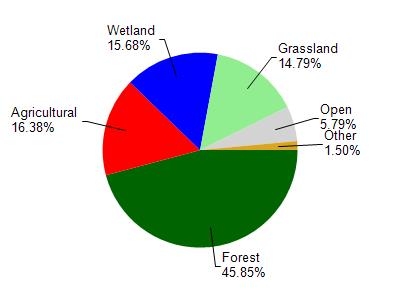
Big Blake Lake is located in the Upper Apple River watershed which is 195.43 miĀ². Land use in the watershed is primarily forest (45.90%), agricultural (16.40%) and a mix of wetland (15.70%) and other uses (22.10%). This watershed has 138.62 stream miles, 7,663.43 lake acres and 16,247.07 wetland acres.

Nonpoint Source Characteristics

This watershed is ranked Medium for runoff impacts on streams, High for runoff impacts on lakes and Low for runoff impacts on groundwater and therefore has an overall rank of Low. This value can be used in ranking the watershed or individual waterbodies for grant funding under state and county programs.This water is ranked High Lake for individual Lakes based on runoff problems and the likelihood of success from project implementation.

Natural Community

Big Blake Lake (Blake) is considered a Shallow Lowland under the state's Natural Community Determinations.

Natural communities (stream and lake natural communities) represent model results and DNR staff valiation processes that confirm or update predicted conditions based on flow and temperature modeling from historic and current landscape features and related variables. Predicated flow and temperatures for waters are associated predicated fish assemblages (communities). Biologists evaluate the model results against current survey data to determine if the modeled results are corect and whether biological indicators show water quaity degradation. This analysis is a core component of the state's resource management framework. Wisconsin's Riverine Natural Communities.

Shallow lowland lake describes the depth and location of the lake in a watershed. These variables affect the lakes response to watershed variables.